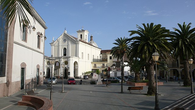
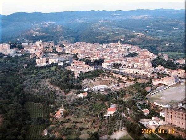
Mondragone (Mondragone)
.svg)
- Italian comune
 Hiking in Mondragone
Mondragone, located in the Campania region of Italy, is a picturesque town situated along the Tyrrhenian Sea. While it may not be widely known for extensive hiking trails, it offers several opportunities for outdoor enthusiasts to explore the natural beauty of the surrounding area.
Hiking Opportunities in Mondragone:
-
Cerro di Mondragone:
- The Cerro, a hill overlooking Mondragone, offers a variety of trails with beautiful views of the town and the coastline. The hike can be moderate, with some steep sections, making it a great option for those looking for a challenge. The area is rich in flora and fauna, so keep an eye out for local wildlife.
-
Gulf of Gaeta:
- Just a short distance from Mondragone, the Gulf of Gaeta provides stunning coastal scenery and several hiking paths. The Traiano Path is popular, allowing hikers to experience breathtaking views of the sea while exploring the coastline.
-
Rocca di Mondragone:
- This historical site features a castle and offers hiking opportunities around and up to the fortification. The trail can take you through scenic areas with historical significance, making for a rewarding hike.
-
Regional Parks:
- The nearby Regional Park of Roccamonfina offers numerous trails amid lush vegetation and volcanic landscapes. The park is a bit further away but is worth exploring for more extensive hiking experiences.
Tips for Hiking in Mondragone:
- Weather Considerations: Be mindful of the weather as it can change quickly. The summer months can be hot, so early morning or late afternoon hikes are recommended.
- Footwear: Wear sturdy hiking boots for better traction, especially if the trail is rocky or steep.
- Hydration and Snacks: Carry enough water and snacks for your hike, as amenities might not be readily available on the trails.
- Respect the Environment: Follow local guidelines for preserving nature, including staying on marked trails and taking your trash with you.
Conclusion:
While Mondragone may not be a sprawling hiking destination, its surrounding areas and trails provide beautiful landscapes and a chance to immerse yourself in the natural beauty of Italy. Whether you're looking for a scenic stroll or a challenging hike, you'll find opportunities to enjoy the great outdoors.
- Country:

- Postal Code: 81034
- Local Dialing Code: 0823
- Licence Plate Code: CE
- Coordinates: 41° 6' 0" N, 13° 53' 0" E


- GPS tracks (wikiloc): [Link]
- AboveSeaLevel: 10 м m
- Area: 55.72 sq km
- Population: 28797
- Web site: http://www.mondragone.net/
- Wikipedia en: wiki(en)
- Wikipedia: wiki(it)
- Wikidata storage: Wikidata: Q58719
- Wikipedia Commons Category: [Link]
- Freebase ID: [/m/0gmzxt]
- GeoNames ID: Alt: [6539457]
- VIAF ID: Alt: [131805852]
- OSM relation ID: [41090]
- GND ID: Alt: [4115188-4]
- PACTOLS thesaurus ID: [pcrtXLydqQgygs]
- Quora topic ID: [Mondragone]
- UN/LOCODE: [ITODG]
- Digital Atlas of the Roman Empire ID: [23680]
- ISTAT ID: 061052
- Italian cadastre code: F352
Shares border with regions:
Cancello e Arnone
- Italian comune
Hiking in Cancello e Arnone
Cancello e Arnone is a small town located in the Campania region of Italy, in the province of Caserta. While it may not be as famous as some of the larger hiking destinations in Italy, it is surrounded by a beautiful landscape that can offer some opportunities for outdoor enthusiasts, particularly if you enjoy a more local and tranquil hiking experience....
- Country:
- Postal Code: 81030
- Local Dialing Code: 0823
- Licence Plate Code: CE
- Coordinates: 41° 4' 24" N, 14° 1' 32" E
- GPS tracks (wikiloc): [Link]
- AboveSeaLevel: 8 м m
- Area: 49.3 sq km
- Population: 5715
- Web site: [Link]
Castel Volturno
- Italian comune
Hiking in Castel Volturno
Castel Volturno is located in the Campania region of Italy, along the Tyrrhenian coast. While it is not primarily known as a hiking destination, there are options for outdoor activity in and around the area. Here are some insights into hiking around Castel Volturno:...
- Country:
- Postal Code: 81030
- Local Dialing Code: 081; 0823
- Licence Plate Code: CE
- Coordinates: 41° 3' 0" N, 13° 55' 0" E
- GPS tracks (wikiloc): [Link]
- AboveSeaLevel: 3 м m
- Area: 73.95 sq km
- Population: 25847
- Web site: [Link]
Falciano del Massico
- Italian comune
Hiking in Falciano del Massico
Falciano del Massico is a charming village located in the Campania region of Italy, near the coast of the Tyrrhenian Sea. The surrounding area features a variety of landscapes, including hills, rural countryside, and Mediterranean vegetation, making it appealing for hiking enthusiasts....
- Country:
- Postal Code: 81030
- Local Dialing Code: 0823
- Licence Plate Code: CE
- Coordinates: 41° 10' 0" N, 13° 57' 0" E
- GPS tracks (wikiloc): [Link]
- AboveSeaLevel: 70 м m
- Area: 42 sq km
- Population: 3621
- Web site: [Link]
Sessa Aurunca
- Italian comune
Hiking in Sessa Aurunca
Sessa Aurunca, located in the province of Caserta in Campania, Italy, is a beautiful destination for hiking enthusiasts. The region is characterized by its stunning landscapes, rich history, and diverse flora and fauna. Here’s a guide for hiking in Sessa Aurunca:...
- Country:
- Postal Code: 81037
- Local Dialing Code: 0823
- Licence Plate Code: CE
- Coordinates: 41° 14' 0" N, 13° 56' 0" E
- GPS tracks (wikiloc): [Link]
- AboveSeaLevel: 203 м m
- Area: 162.18 sq km
- Population: 21252
- Web site: [Link]