Sessa Aurunca (Sessa Aurunca)
.svg)
- Italian comune
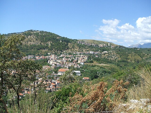
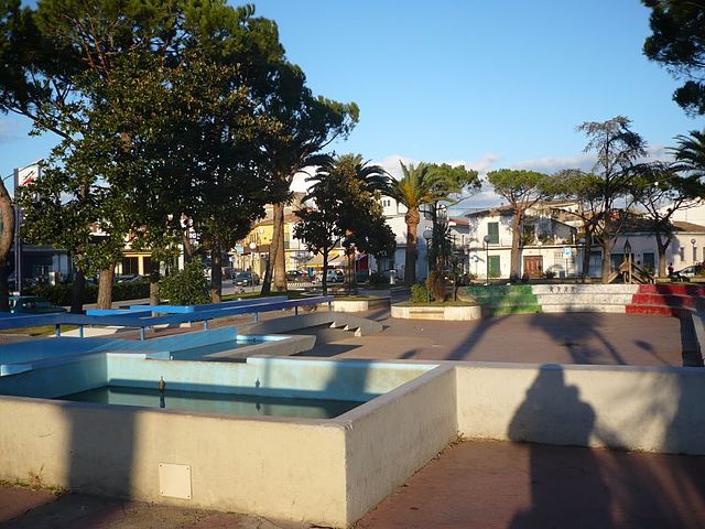
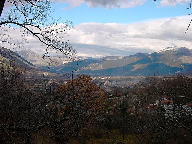
 Hiking in Sessa Aurunca
Sessa Aurunca, located in the province of Caserta in Campania, Italy, is a beautiful destination for hiking enthusiasts. The region is characterized by its stunning landscapes, rich history, and diverse flora and fauna. Here’s a guide for hiking in Sessa Aurunca:
Trails and Areas to Explore:
-
Monte Aurunci Regional Park: This park offers a variety of trails with breathtaking views of the Aurunci Mountains and the surrounding countryside. The trails range in difficulty, making it accessible for both beginners and experienced hikers. The park is well-marked, allowing for exploration of various routes.
-
The Path of the Monks: This historic route leads through ancient sites and offers an opportunity to see historic monasteries while enjoying panoramic views. The trail is moderately difficult, so it's ideal for those looking for both a physical challenge and cultural enrichment.
-
Ancient Roman Ruins: As a hike through Sessa Aurunca, you can incorporate visits to the ancient ruins, including the Roman theatre and the remains of the ancient city. This adds a unique historical layer to your hiking experience.
-
Scenic Views: Many trails offer viewpoints overlooking the Gulf of Gaeta or the rolling hills of the surrounding areas. Catching a sunset from a vantage point can be particularly stunning.
Best Times to Hike:
- Spring (April - June): Ideal for hiking, with mild temperatures and blooming wildflowers.
- Fall (September - November): Another excellent time regarding weather and scenery, as the autumn foliage adds colorful contrasts to the landscape.
Recommendations:
- Preparation: Always check the weather forecast and prepare accordingly. Carry enough water, snacks, and a map or GPS.
- Footwear: Invest in good hiking boots for comfort and support on varied terrain.
- Guided Tours: If you’re unfamiliar with the area, consider joining a guided hiking tour to get expert insights into the local ecology and history.
Safety:
- Always inform someone about your hiking route and expected return time.
- Stay on marked trails to protect natural habitats and for your safety.
- Be aware of wildlife and know how to react if you encounter any.
Local Culture and Cuisine:
Don’t forget to enjoy local cuisine after your hikes. Sessa Aurunca is known for its delicious dishes and local wines. Try local specialties, especially if you're hiking in the fall during grape harvesting season.
Whether you’re seeking natural beauty, historical insights, or a physical challenge, hiking in Sessa Aurunca offers a memorable experience amidst stunning Italian landscapes.
- Country:

- Postal Code: 81037
- Local Dialing Code: 0823
- Licence Plate Code: CE
- Coordinates: 41° 14' 0" N, 13° 56' 0" E


- GPS tracks (wikiloc): [Link]
- AboveSeaLevel: 203 м m
- Area: 162.18 sq km
- Population: 21252
- Web site: http://www.sessaaurunca.net
- Wikipedia en: wiki(en)
- Wikipedia: wiki(it)
- Wikidata storage: Wikidata: Q58898
- Wikipedia Commons Category: [Link]
- Freebase ID: [/m/078v_l]
- GeoNames ID: Alt: [6538731]
- BnF ID: [14625344t]
- VIAF ID: Alt: [130259019]
- OSM relation ID: [41131]
- GND ID: Alt: [4282777-2]
- Library of Congress authority ID: Alt: [n85298483]
- PACTOLS thesaurus ID: [pcrtrBcEUgec83]
- WOEID: [724129]
- UN/LOCODE: [ITSAU]
- Encyclopædia Britannica Online ID: [place/Sessa-Aurunca]
- EMLO location ID: [ee4293d9-dfa1-46d4-abea-9981bb0c2ef1]
- Digital Atlas of the Roman Empire ID: [16715]
- Nomisma ID: [suessa_aurunca]
- ISTAT ID: 061088
- Italian cadastre code: I676
Shares border with regions:


Castelforte
- Italian comune
Hiking in Castelforte
Castelforte, located in the region of Lazio, Italy, is a quaint town that offers various outdoor activities, including hiking. The surrounding areas are characterized by beautiful landscapes, rolling hills, and natural beauty, making it an appealing destination for outdoor enthusiasts....
- Country:
- Postal Code: 04021
- Local Dialing Code: 0771
- Licence Plate Code: LT
- Coordinates: 41° 18' 0" N, 13° 50' 0" E
- GPS tracks (wikiloc): [Link]
- AboveSeaLevel: 130 м m
- Area: 29.71 sq km
- Population: 4221
- Web site: [Link]


Minturno
- Italian comune
Hiking in Minturno
Minturno, located in the province of Latina, Italy, offers a unique combination of historical sites and beautiful natural scenery, making it a great destination for hiking enthusiasts. The region is characterized by the striking landscapes of the Aurunci Mountains, lush Mediterranean vegetation, and views of the Tyrrhenian Sea....
- Country:
- Postal Code: 04026 - 04028 (Scauri e Marina)
- Local Dialing Code: 0771
- Licence Plate Code: LT
- Coordinates: 41° 16' 0" N, 13° 45' 0" E
- GPS tracks (wikiloc): [Link]
- AboveSeaLevel: 141 м m
- Area: 42.14 sq km
- Population: 19804
- Web site: [Link]

Santi Cosma e Damiano, Lazio
- Italian comune
Hiking in Santi Cosma e Damiano, Lazio
Santi Cosma e Damiano is a charming village located in the province of Latina in the Lazio region of Italy. It's surrounded by beautiful landscapes, rich history, and a variety of trails that can cater to different skill levels – making it a nice destination for hikers....
- Country:
- Postal Code: 04020
- Local Dialing Code: 0771
- Licence Plate Code: LT
- Coordinates: 41° 18' 0" N, 13° 49' 0" E
- GPS tracks (wikiloc): [Link]
- AboveSeaLevel: 181 м m
- Area: 31.61 sq km
- Population: 6972
- Web site: [Link]
Carinola
- Italian comune
Hiking in Carinola
Carinola, located in the Campania region of Italy, offers a unique blend of natural beauty, historical sites, and scenic landscapes that make it a great destination for hiking enthusiasts....
- Country:
- Postal Code: 81030
- Local Dialing Code: 0823
- Licence Plate Code: CE
- Coordinates: 41° 11' 0" N, 13° 59' 0" E
- GPS tracks (wikiloc): [Link]
- AboveSeaLevel: 71 м m
- Area: 59.23 sq km
- Population: 7248
- Web site: [Link]
Cellole
- Italian comune
Hiking in Cellole
Cellole, located in the province of Caserta in Italy, offers a range of hiking opportunities, particularly for those who enjoy exploring the natural beauty of the region. Although it's a small town, it serves as a gateway to various trails and natural settings in the surrounding area. Here are some key points to consider if you're planning to hike in Cellole:...
- Country:
- Postal Code: 81030
- Local Dialing Code: 0823
- Licence Plate Code: CE
- Coordinates: 41° 12' 0" N, 13° 51' 0" E
- GPS tracks (wikiloc): [Link]
- AboveSeaLevel: 17 м m
- Area: 36.79 sq km
- Population: 7937
- Web site: [Link]
Falciano del Massico
- Italian comune
Hiking in Falciano del Massico
Falciano del Massico is a charming village located in the Campania region of Italy, near the coast of the Tyrrhenian Sea. The surrounding area features a variety of landscapes, including hills, rural countryside, and Mediterranean vegetation, making it appealing for hiking enthusiasts....
- Country:
- Postal Code: 81030
- Local Dialing Code: 0823
- Licence Plate Code: CE
- Coordinates: 41° 10' 0" N, 13° 57' 0" E
- GPS tracks (wikiloc): [Link]
- AboveSeaLevel: 70 м m
- Area: 42 sq km
- Population: 3621
- Web site: [Link]
Galluccio
- Italian comune
Hiking in Galluccio
Galluccio, located in the province of Caserta in the Campania region of Italy, offers a beautiful setting for hiking enthusiasts. Nestled within the picturesque landscape of the Aurunci Mountains, the area is known for its diverse terrain, rich vegetation, and stunning views. Here are some highlights to consider when hiking in Galluccio:...
- Country:
- Postal Code: 81044
- Local Dialing Code: 0823
- Licence Plate Code: CE
- Coordinates: 41° 21' 0" N, 13° 57' 0" E
- GPS tracks (wikiloc): [Link]
- AboveSeaLevel: 368 м m
- Area: 32.11 sq km
- Population: 2152
- Web site: [Link]
Mondragone
- Italian comune
Hiking in Mondragone
Mondragone, located in the Campania region of Italy, is a picturesque town situated along the Tyrrhenian Sea. While it may not be widely known for extensive hiking trails, it offers several opportunities for outdoor enthusiasts to explore the natural beauty of the surrounding area....
- Country:
- Postal Code: 81034
- Local Dialing Code: 0823
- Licence Plate Code: CE
- Coordinates: 41° 6' 0" N, 13° 53' 0" E
- GPS tracks (wikiloc): [Link]
- AboveSeaLevel: 10 м m
- Area: 55.72 sq km
- Population: 28797
- Web site: [Link]
Rocca d'Evandro
- Italian comune
Hiking in Rocca d'Evandro
Rocca d'Evandro is a picturesque town located in the province of Caserta in southern Italy. Nestled in the foothills of the Matese Mountains, it offers a range of hiking opportunities for both novice and experienced hikers. Here are some key points to consider if you're planning to hike in this area:...
- Country:
- Postal Code: 81040
- Local Dialing Code: 0823
- Licence Plate Code: CE
- Coordinates: 41° 23' 0" N, 13° 53' 0" E
- GPS tracks (wikiloc): [Link]
- AboveSeaLevel: 83 м m
- Area: 49.54 sq km
- Population: 3178
- Web site: [Link]

Roccamonfina
- Italian comune
Hiking in Roccamonfina
Roccamonfina is a stunning mountain area located in the Campania region of Italy, known for its natural beauty, biodiversity, and rich history. The region is characterized by a variety of landscapes, including volcanic hills, lush forests, and panoramic views, making it an excellent destination for hiking enthusiasts....
- Country:
- Postal Code: 81035
- Local Dialing Code: 0823
- Licence Plate Code: CE
- Coordinates: 41° 18' 0" N, 13° 59' 0" E
- GPS tracks (wikiloc): [Link]
- AboveSeaLevel: 612 м m
- Area: 31.04 sq km
- Population: 3399
- Web site: [Link]

Teano
- Italian comune
Hiking in Teano
Teano, located in the Campania region of Italy, is surrounded by beautiful landscapes that make it a great destination for hiking enthusiasts. The area is characterized by its rolling hills, lush greenery, and scenic views, offering a variety of trails suitable for different skill levels....
- Country:
- Postal Code: 81057
- Local Dialing Code: 0823
- Licence Plate Code: CE
- Coordinates: 41° 15' 0" N, 14° 4' 0" E
- GPS tracks (wikiloc): [Link]
- AboveSeaLevel: 196 м m
- Area: 89.43 sq km
- Population: 12303
- Web site: [Link]