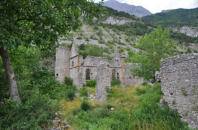
Monestier-d'Ambel (Monestier-d'Ambel)

- commune in Isère, France
 Hiking in Monestier-d'Ambel
Monestier-d'Ambel is a picturesque commune located in the Isère department in the Auvergne-Rhône-Alpes region of southeastern France. Nestled in the French Alps, it offers a variety of hiking opportunities for outdoor enthusiasts. Here are some details about hiking in this area:
Trails and Scenery
-
Diverse Terrain: The region boasts diverse ecosystems, from lush forests to alpine meadows, which are rich in flora and fauna. As you hike, you might encounter various wildlife, including deer, foxes, and a variety of bird species.
-
Panoramic Views: Many trails in and around Monestier-d'Ambel offer stunning vistas of the surrounding mountains, particularly the Taillefer massif. Clear days can provide breathtaking views of the Alps.
-
Trail Options: There are trails suitable for all levels, from easy walks perfect for families to challenging hikes that require more experience. Some popular routes include:
- Circuit des Moulins: A relatively easy trail that can be great for families or beginners.
- Hikes toward Col de la Croix: For those looking for a bit more adventure, trails leading to high mountain passes are available.
Seasonal Considerations
- Summer: The summer months provide the best hiking conditions, with milder weather and accessible trails. Wildflowers bloom, and the scenery is lush and green.
- Autumn: The fall can be an excellent time for hiking as the foliage changes colors, providing a beautiful backdrop for your hikes.
- Winter: If you're interested in snowshoeing or winter hiking, check conditions as snow can cover many trails, offering a different perspective on the landscape.
Preparation
- Gear: Always wear suitable hiking boots and bring layers, as temperatures can vary, especially in the mountains. A map or GPS device is also advisable.
- Water and Snacks: Carry sufficient water and energy snacks to keep you fueled during your hikes.
- Local Guidance: If you're unfamiliar with the area, consider hiring a local guide or joining a hiking group. They can enhance your experience with their knowledge of the region.
Conservation
As always, practice Leave No Trace principles to preserve the natural beauty of Monestier-d'Ambel. Stay on marked trails and respect the local wildlife and vegetation.
Overall, Monestier-d'Ambel is an excellent destination for hiking, offering both novice and seasoned hikers an opportunity to explore the natural beauty of the French Alps.
- Country:

- Postal Code: 38970
- Coordinates: 44° 46' 40" N, 5° 55' 37" E


- GPS tracks (wikiloc): [Link]
- Area: 11.02 sq km
- Population: 22
- Web site: http://www.monestierdambel.fr
- Wikipedia en: wiki(en)
- Wikipedia: wiki(fr)
- Wikidata storage: Wikidata: Q1070017
- Wikipedia Commons Category: [Link]
- Freebase ID: [/m/03nvgl8]
- GeoNames ID: Alt: [6433247]
- SIREN number: [213802416]
- BnF ID: [15258053r]
- INSEE municipality code: 38241
Shares border with regions:
Le Glaizil
- commune in Hautes-Alpes, France
Hiking in Le Glaizil
Le Glaizil is a picturesque commune located in the Hautes-Alpes department in southeastern France. The surrounding area is known for its stunning landscapes, including mountains, valleys, and diverse flora and fauna, which make it a great destination for hiking enthusiasts....
- Country:
- Postal Code: 05800
- Coordinates: 44° 45' 13" N, 5° 58' 59" E
- GPS tracks (wikiloc): [Link]
- Area: 21.93 sq km
- Population: 174


Ambel
- commune in Isère, France
Hiking in Ambel
Hiking in Ambel, located in the Isère department of the Auvergne-Rhône-Alpes region in France, offers a serene experience surrounded by beautiful landscapes, mountainous terrain, and rich biodiversity. Here are some key points to know about hiking in this area:...
- Country:
- Postal Code: 38970
- Coordinates: 44° 48' 18" N, 5° 55' 50" E
- GPS tracks (wikiloc): [Link]
- Area: 4.83 sq km
- Population: 22

Saint-Disdier
- former commune in Hautes-Alpes, France
Hiking in Saint-Disdier
Saint-Disdier, located in the Hautes-Alpes region of France, offers a wonderful environment for hiking enthusiasts. Surrounded by the stunning landscapes of the Southern French Alps, the area is known for its picturesque trails, diverse ecosystems, and breathtaking views....
- Country:
- Postal Code: 05250
- Coordinates: 44° 44' 0" N, 5° 54' 0" E
- GPS tracks (wikiloc): [Link]
- AboveSeaLevel: 1040 м m
- Population: 139

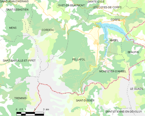
Pellafol
- commune in Isère, France
Hiking in Pellafol
Pellafol, a picturesque village located in the Isère department of the Auvergne-Rhône-Alpes region in France, is a hidden gem for hiking enthusiasts. Nestled in the foothills of the French Alps, it offers stunning landscapes, diverse flora and fauna, and a variety of trails suitable for all skill levels....
- Country:
- Postal Code: 38970
- Coordinates: 44° 47' 51" N, 5° 54' 27" E
- GPS tracks (wikiloc): [Link]
- Area: 34.73 sq km
- Population: 137


Beaufin
- commune in Isère, France
Hiking in Beaufin
Beaufin is not a widely recognized hiking destination, and there may be some confusion about the name. However, if you meant Beaufort, a region in various countries, or perhaps a specific national park or area with a similar name, please clarify!...
- Country:
- Postal Code: 38970
- Coordinates: 44° 47' 16" N, 5° 57' 36" E
- GPS tracks (wikiloc): [Link]
- Area: 6.36 sq km
- Population: 21
Dévoluy
- commune in Hautes-Alpes, France
Hiking in Dévoluy
Le Dévoluy is a stunning mountain range located in the French Alps, known for its diverse landscapes, breathtaking scenery, and extensive hiking opportunities. Whether you're an experienced hiker or a beginner, there's something for everyone in this area....
- Country:
- Postal Code: 05250
- Coordinates: 44° 41' 33" N, 5° 56' 28" E
- GPS tracks (wikiloc): [Link]
- Area: 186.37 sq km
- Population: 1011
- Web site: [Link]