Mont-de-Lans (Mont-de-Lans)

- former commune in Isère, France
 Hiking in Mont-de-Lans
Mont-de-Lans, located in the French Alps, is a scenic area that offers a variety of hiking opportunities for all levels of hikers. Situated near the famous ski resort of Les Deux Alpes, it transforms into a hiker’s paradise during the warmer months, showcasing stunning alpine landscapes, breathtaking views, and diverse flora and fauna.
Hiking Trails
-
Lac du Chambon: This trail takes you around a beautiful alpine lake, ideal for family hiking. The relatively easy path offers breathtaking views, perfect for picnicking.
-
Refuge de l'Alpe de Villar d'Arène: A moderate hike leading you to a charming mountain refuge. The trail winds through beautiful meadows and offers a great chance to spot local wildlife.
-
Col de la Muzelle: This trail provides a more challenging trek with stunning views of the surrounding peaks and valleys. It’s suited for experienced hikers, and reaching the col rewards you with panoramic vistas.
-
Les Deux Alpes Glacier: For those looking for unique hiking experiences, you can hike around the glacier in the summer months. This offers a chance to see the high-altitude environment and glacial features up close.
Best Time to Hike
The ideal time for hiking in Mont-de-Lans is during late spring to early fall (May to September). Summer offers the best weather, and the trails are usually well-marked and accessible. However, conditions can change quickly in the mountains, so it's essential to check the local weather forecasts and trail conditions before heading out.
Preparation
- Physical Fitness: Ensure you’re in good shape for the desired trail. Some routes require a good level of fitness and hiking experience.
- Gear: Wear proper hiking boots, and bring layers of clothing, as temperatures can vary significantly. Don't forget essentials like a map, hydration, and snacks.
- Safety: Always let someone know your plans, and consider going with a group if you’re unfamiliar with the terrain.
Additional Tips
- Local Guides: If you're uncertain about navigating trails or want a more in-depth experience, consider hiring a local guide.
- Respect Nature: Follow the Leave No Trace principles to help preserve the natural beauty of the area.
- Wildlife Caution: Be aware of local wildlife and maintain a safe distance if you encounter any animals.
Overall, hiking in Mont-de-Lans offers an unforgettable experience filled with natural beauty, adventure, and a chance to connect with the stunning alpine environment.
- Country:

- Postal Code: 38860
- Coordinates: 45° 2' 9" N, 6° 7' 44" E


- GPS tracks (wikiloc): [Link]
- Area: 31.66 sq km
- Population: 1129
- Web site: http://www.mairiedemontdelansles2alpes.fr
- Wikipedia en: wiki(en)
- Wikipedia: wiki(fr)
- Wikidata storage: Wikidata: Q1154596
- Wikipedia Commons Category: [Link]
- Freebase ID: [/m/03g_1jg]
- GeoNames ID: Alt: [2992777]
- BnF ID: [15258065r]
- INSEE municipality code: 38253
Shares border with regions:

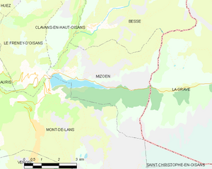
Mizoën
- commune in Isère, France
Hiking in Mizoën
Mizoën is a charming village located in the Écrins National Park in the French Alps. This picturesque region is known for its stunning landscapes, pristine wilderness, and variety of hiking trails suitable for all levels of experience. Here’s some information to help you plan your hiking adventure in Mizoën:...
- Country:
- Postal Code: 38142
- Coordinates: 45° 3' 0" N, 6° 8' 33" E
- GPS tracks (wikiloc): [Link]
- Area: 14.6 sq km
- Population: 195
- Web site: [Link]


Vénosc
- former commune in Isère, France
Hiking in Vénosc
Vénosc is a charming mountain village located in the French Alps, near the popular ski resort of Les Deux Alpes in the Isère department. The area offers a variety of hiking opportunities that cater to different skill levels, from leisurely walks to challenging mountain trails. Here are some highlights of hiking in Vénosc:...
- Country:
- Postal Code: 38520
- Coordinates: 44° 59' 24" N, 6° 6' 56" E
- GPS tracks (wikiloc): [Link]
- Area: 25.06 sq km
- Population: 765
- Web site: [Link]


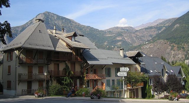
Le Freney-d'Oisans
- commune in Isère, France
Hiking in Le Freney-d'Oisans
Le Freney-d'Oisans is a charming village located in the Auvergne-Rhône-Alpes region of France, nestled in the French Alps. It's a fantastic location for hiking enthusiasts due to its stunning natural scenery, diverse trails, and proximity to other outdoor activities....
- Country:
- Postal Code: 38142
- Coordinates: 45° 2' 41" N, 6° 7' 32" E
- GPS tracks (wikiloc): [Link]
- Area: 14.54 sq km
- Population: 252
- Web site: [Link]
Le Bourg-d'Oisans
- commune in Isère, France
Hiking in Le Bourg-d'Oisans
Le Bourg-d'Oisans is a charming commune located in the French Alps, nestled between the Oisans mountain range and the breathtaking Ecrins National Park. It's an excellent base for those who enjoy hiking, as it offers a variety of trails suitable for all experience levels, from beginner to advanced....
- Country:
- Postal Code: 38520
- Coordinates: 45° 3' 19" N, 6° 1' 46" E
- GPS tracks (wikiloc): [Link]
- Area: 35.75 sq km
- Population: 3239
- Web site: [Link]


Auris
- commune in Isère, France
Hiking in Auris
Auris, located in the Isère department of the Auvergne-Rhône-Alpes region in France, offers stunning hiking opportunities, especially for those looking to explore the beautiful landscapes of the French Alps. Here’s a guide to hiking in Auris:...
- Country:
- Postal Code: 38142
- Coordinates: 45° 2' 47" N, 6° 5' 12" E
- GPS tracks (wikiloc): [Link]
- Area: 11.21 sq km
- Population: 201
- Web site: [Link]

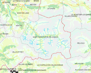
Saint-Christophe-en-Oisans
- commune in Isère, France
Hiking in Saint-Christophe-en-Oisans
Saint-Christophe-en-Oisans is a charming village located in the French Alps, nestled within the Oisans valley. It serves as a gateway to some stunning hiking opportunities in the surrounding terrain, known for its breathtaking scenery, diverse ecosystems, and the proximity to the Écrins National Park....
- Country:
- Postal Code: 38520
- Coordinates: 44° 57' 26" N, 6° 10' 37" E
- GPS tracks (wikiloc): [Link]
- Area: 123.5 sq km
- Population: 105
- Web site: [Link]