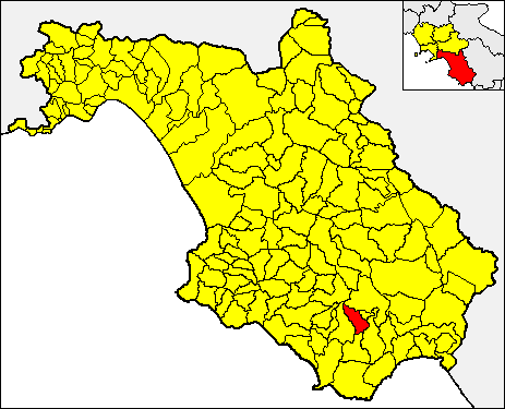
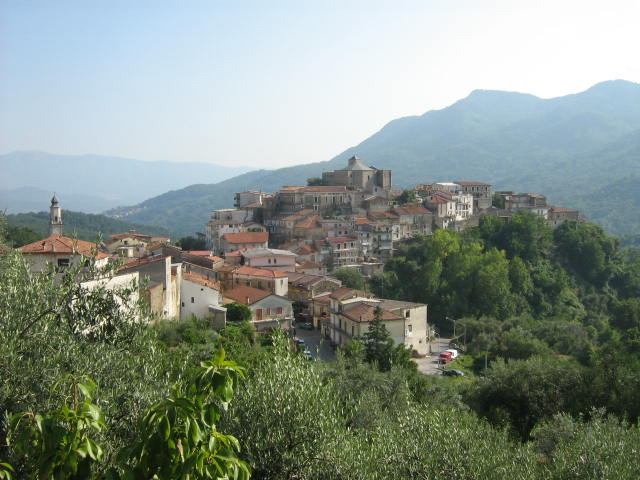
Montano Antilia (Montano Antilia)

- Italian comune
 Hiking in Montano Antilia
Montano Antilia is a charming town located in the Campania region of Italy, surrounded by the majestic landscapes of the Cilento National Park. This area is known for its rugged terrain, lush greenery, and stunning coastal views, making it an excellent destination for hiking enthusiasts.
Hiking Opportunities
-
Cilento National Park: This park offers a variety of trails ranging from easy walks to challenging hikes. The park is rich in biodiversity, with flora and fauna unique to this region. Some popular trails include those leading to coastal viewpoints, ancient ruins, and through dense forests.
-
Sentiero degli Dei (Path of the Gods): Although not directly in Montano Antilia, this iconic hike is located nearby. The trail offers breathtaking views of the Amalfi Coast and is a must-do for those in the area. It typically takes around 5-7 hours to complete.
-
Monte Stella: A hike to Monte Stella, which rises just outside Montano Antilia, offers panoramic views of both the sea and surrounding mountains. The trails vary in difficulty and are well-marked, making them accessible for most hikers.
-
Local Trails: Many local trails start from Montano Antilia itself, leading you through charming rural landscapes, olive groves, and picturesque village features. These trails can lead you to secluded spots, offering a more intimate hiking experience.
Practical Tips
-
Season and Weather: The best times to hike in this area are during spring (April to June) and fall (September to October) when temperatures are milder and the scenery is particularly beautiful. Summers can be hot, so plan hikes early in the day.
-
Trail Conditions: Always check trail conditions before heading out, especially after heavy rains, as trails can sometimes be affected by landslips or muddy conditions.
-
Resources: Consider hiring a local guide or joining a hiking group for a more enriching experience. Local guides can offer insights into the area’s history, culture, and ecology.
-
Safety: Always carry plenty of water, wear appropriate footwear, and let someone know your hiking plans.
-
Leave No Trace: As with any hiking destination, respect nature by following Leave No Trace principles. Stick to established trails, and pack out what you bring in.
Hiking in and around Montano Antilia promises stunning natural beauty and a chance to experience the serene charm of the Italian countryside. Enjoy your adventure!
- Country:

- Postal Code: 84060
- Local Dialing Code: 0974
- Licence Plate Code: SA
- Coordinates: 40° 9' 43" N, 15° 22' 0" E


- GPS tracks (wikiloc): [Link]
- AboveSeaLevel: 700 м m
- Area: 33.44 sq km
- Population: 2019
- Web site: http://www.comune.montano-antilia.sa.it/
- Wikipedia en: wiki(en)
- Wikipedia: wiki(it)
- Wikidata storage: Wikidata: Q81057
- Wikipedia Commons Category: [Link]
- Freebase ID: [/m/0frfyj]
- GeoNames ID: Alt: [6538820]
- OSM relation ID: [40298]
- ISTAT ID: 065070
- Italian cadastre code: F426
Shares border with regions:

Laurito
- Italian comune
Hiking in Laurito
Laurito is a charming village located in the Campania region of Italy, nestled in the mountains of the Cilento and Vallo di Diano National Park. This area is known for its stunning landscapes, rich biodiversity, and historical significance....
- Country:
- Postal Code: 84050
- Local Dialing Code: 0974
- Licence Plate Code: SA
- Coordinates: 40° 10' 0" N, 15° 24' 0" E
- GPS tracks (wikiloc): [Link]
- AboveSeaLevel: 475 м m
- Area: 20.22 sq km
- Population: 782
- Web site: [Link]


Celle di Bulgheria
- Italian comune
Hiking in Celle di Bulgheria
Celle di Bulgheria, a charming village located in the Cilento and Vallo di Diano National Park in southern Italy, offers a variety of hiking opportunities that cater to both novice and experienced hikers. Here are some key points to consider when hiking in this beautiful area:...
- Country:
- Postal Code: 84040
- Local Dialing Code: 0974
- Licence Plate Code: SA
- Coordinates: 40° 6' 0" N, 15° 24' 0" E
- GPS tracks (wikiloc): [Link]
- AboveSeaLevel: 234 м m
- Area: 31.62 sq km
- Population: 1861
- Web site: [Link]


Centola
- Italian comune
Hiking in Centola
Centola is a charming town located in the Cilento region of Italy, near the beautiful coastline of the Tyrrhenian Sea. The area is known for its stunning vistas, diverse landscapes, and well-preserved natural parks, making it a fantastic destination for hiking enthusiasts....
- Country:
- Postal Code: 84051
- Local Dialing Code: 0974
- Licence Plate Code: SA
- Coordinates: 40° 4' 11" N, 15° 18' 43" E
- GPS tracks (wikiloc): [Link]
- AboveSeaLevel: 336 м m
- Area: 47.75 sq km
- Population: 5153
- Web site: [Link]
Futani
- Italian comune
Hiking in Futani
Futani, often known for its beautiful landscapes and serene environments, offers a variety of hiking opportunities for both novice and experienced hikers. Here’s an overview of what you can expect when hiking in this region:...
- Country:
- Postal Code: 84050
- Local Dialing Code: 0974-953012
- Licence Plate Code: SA
- Coordinates: 40° 9' 6" N, 15° 19' 20" E
- GPS tracks (wikiloc): [Link]
- AboveSeaLevel: 431 м m
- Area: 14.85 sq km
- Population: 1170
- Web site: [Link]


Novi Velia
- Italian comune
Hiking in Novi Velia
Novi Velia is a charming town located in the Cilento region of southern Italy, known for its beautiful landscapes and opportunities for hiking. Nestled in the Parco Nazionale del Cilento, Vallo di Diano e Alburni, it offers stunning views, diverse terrains, and a rich natural environment....
- Country:
- Postal Code: 84060
- Local Dialing Code: 0974
- Licence Plate Code: SA
- Coordinates: 40° 13' 0" N, 15° 17' 0" E
- GPS tracks (wikiloc): [Link]
- AboveSeaLevel: 648 м m
- Area: 34.71 sq km
- Population: 2292
- Web site: [Link]

Rofrano
- Italian comune
Hiking in Rofrano
Rofrano, a picturesque village in the Campania region of southern Italy, is surrounded by the stunning landscapes of the Cilento and Vallo di Diano National Park. This area is rich in natural beauty, offering a variety of hiking opportunities suitable for different skill levels....
- Country:
- Postal Code: 84070
- Local Dialing Code: 0974
- Licence Plate Code: SA
- Coordinates: 40° 13' 0" N, 15° 26' 0" E
- GPS tracks (wikiloc): [Link]
- AboveSeaLevel: 450 м m
- Area: 63.59 sq km
- Population: 1509
- Web site: [Link]


San Mauro La Bruca
- Italian comune
Hiking in San Mauro La Bruca
San Mauro la Bruca is a charming village located in the Cilento region of southern Italy, known for its stunning landscapes, rich history, and proximity to the Cilento and Vallo di Diano National Park. Hiking in this area offers a unique blend of natural beauty, cultural heritage, and diverse trails suitable for various skill levels....
- Country:
- Postal Code: 84070
- Local Dialing Code: 0974
- Licence Plate Code: SA
- Coordinates: 40° 7' 0" N, 15° 17' 0" E
- GPS tracks (wikiloc): [Link]
- AboveSeaLevel: 450 м m
- Area: 19.05 sq km
- Population: 571
- Web site: [Link]