Montbrun (Montbrun)

- former commune in Lozère, France
- Country:

- Postal Code: 48210
- Coordinates: 44° 20' 14" N, 3° 30' 13" E


- GPS tracks (wikiloc): [Link]
- Area: 29.97 sq km
- Population: 112
- Wikipedia en: wiki(en)
- Wikipedia: wiki(fr)
- Wikidata storage: Wikidata: Q636604
- Wikipedia Commons Category: [Link]
- Freebase ID: [/m/02z0zxn]
- Freebase ID: [/m/02z0zxn]
- GeoNames ID: Alt: [6454191]
- GeoNames ID: Alt: [6454191]
- BnF ID: [15261507g]
- BnF ID: [15261507g]
- INSEE municipality code: 48101
- INSEE municipality code: 48101
Shares border with regions:

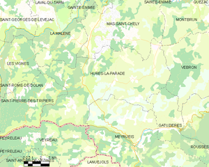
Hures-la-Parade
- commune in Lozère, France
- Country:
- Postal Code: 48150
- Coordinates: 44° 14' 41" N, 3° 21' 9" E
- GPS tracks (wikiloc): [Link]
- AboveSeaLevel: 1000 м m
- Area: 88.59 sq km
- Population: 274


Sainte-Enimie
- former commune in Lozère, France
- Country:
- Postal Code: 48210
- Coordinates: 44° 21' 59" N, 3° 24' 41" E
- GPS tracks (wikiloc): [Link]
- Area: 87.34 sq km
- Population: 533
- Web site: [Link]


Florac
- former commune in Lozère, France
- Country:
- Postal Code: 48400
- Coordinates: 44° 19' 34" N, 3° 35' 35" E
- GPS tracks (wikiloc): [Link]
- Area: 29.89 sq km
- Population: 1909
- Web site: [Link]


Quézac
- former commune in Lozère, France
- Country:
- Postal Code: 48320
- Coordinates: 44° 22' 12" N, 3° 31' 30" E
- GPS tracks (wikiloc): [Link]
- Area: 26.91 sq km
- Population: 336

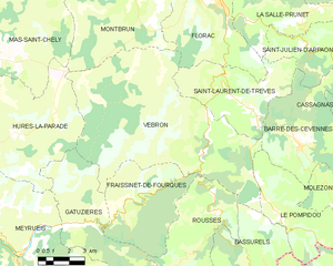
Vebron
- commune in Lozère, France
- Country:
- Postal Code: 48400
- Coordinates: 44° 14' 21" N, 3° 34' 40" E
- GPS tracks (wikiloc): [Link]
- Area: 69.66 sq km
- Population: 197
- Web site: [Link]

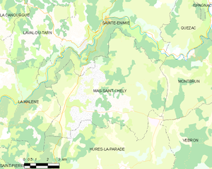
Mas-Saint-Chély
- commune in Lozère, France
- Country:
- Postal Code: 48210
- Coordinates: 44° 18' 32" N, 3° 23' 46" E
- GPS tracks (wikiloc): [Link]
- Area: 56.81 sq km
- Population: 119