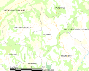
Montchenu (Montchenu)

- commune in Drôme, France
 Hiking in Montchenu
Montchenu is a charming village located in the Drôme region of southeastern France. It offers access to beautiful natural landscapes, making it an ideal destination for hiking enthusiasts.
Hiking Trails:
-
Local Paths: Montchenu has several well-marked hiking trails that vary in difficulty, allowing both beginners and experienced hikers to enjoy the surroundings. You can find paths that wind through vineyards, forests, and along the banks of the Rhône River.
-
The Vercors Regional Natural Park: Nearby, you'll find the Vercors massif, which is renowned for its stunning scenery and diverse ecosystems. The park features trails with breathtaking views, rugged landscapes, and unique geological formations.
-
La Voie Véloroute: This cycling and hiking path runs along the Rhône River and can be accessed from Montchenu. It’s a great option for those looking to extend their hike or combine biking with hiking.
Notable Points of Interest:
- Scenic Vistas: Many trails offer panoramic views of the surrounding hills and valleys. Be sure to carry your camera!
- Flora and Fauna: The area is rich in biodiversity; you may encounter various species of plants, birds, and other wildlife.
- Cultural Sites: You might see historical buildings or ancient ruins along the trails, adding a cultural dimension to your hiking experience.
Tips for Hiking in Montchenu:
- Plan Ahead: Familiarize yourself with the trail maps and local conditions. The terrain can vary, so make sure you choose a trail suitable for your fitness level.
- Proper Gear: Wear sturdy hiking boots, and dress in layers to adapt to changing weather conditions. Carry enough water and snacks.
- Respect Nature: Follow Leave No Trace principles to preserve the natural environment. Stay on marked paths and take all trash with you.
Best Times to Hike:
- Spring (April to June): Ideal for wildflower blooms and milder temperatures.
- Fall (September to October): Enjoy stunning autumn colors and cooler hiking conditions.
Conclusion:
Montchenu is a delightful destination for those looking to explore the natural beauty of southeastern France. Whether you're traversing local trails or venturing into the nearby Vercors, you'll find plenty of opportunities to connect with nature and enjoy outdoor adventure.
- Country:

- Postal Code: 26350
- Coordinates: 45° 11' 44" N, 5° 1' 55" E


- GPS tracks (wikiloc): [Link]
- Area: 16.15 sq km
- Population: 582
- Wikipedia en: wiki(en)
- Wikipedia: wiki(fr)
- Wikidata storage: Wikidata: Q470911
- Wikipedia Commons Category: [Link]
- Freebase ID: [/m/03mgj_7]
- GeoNames ID: Alt: [6430136]
- SIREN number: [212601942]
- BnF ID: [152530557]
- INSEE municipality code: 26194
Shares border with regions:


Saint-Christophe-et-le-Laris
- commune in Drôme, France
Hiking in Saint-Christophe-et-le-Laris
Saint-Christophe-et-le-Laris is a picturesque commune located in the Drôme department in southeastern France. While it may not be as widely known as some larger hiking areas, it offers beautiful landscapes and opportunities for outdoor activities in a serene environment....
- Country:
- Postal Code: 26350
- Coordinates: 45° 12' 36" N, 5° 4' 19" E
- GPS tracks (wikiloc): [Link]
- Area: 11.35 sq km
- Population: 413

Tersanne
- commune in Drôme, France
Hiking in Tersanne
Tersanne is a picturesque region in the French Alps, known for its stunning landscapes, diverse wildlife, and a variety of hiking trails catering to different skill levels. Hiking in this area offers a unique opportunity to experience the natural beauty of the Alps, from lush valleys and meandering rivers to towering mountain peaks....
- Country:
- Postal Code: 26390
- Coordinates: 45° 13' 34" N, 5° 1' 2" E
- GPS tracks (wikiloc): [Link]
- Area: 9.49 sq km
- Population: 359


Bathernay
- commune in Drôme, France
Hiking in Bathernay
Bathernay is a charming commune in the Rhône department of France, nestled in the Auvergne-Rhône-Alpes region. While it may not be as widely known as some other hiking destinations, the surrounding areas offer beautiful landscapes and opportunities for outdoor exploration....
- Country:
- Postal Code: 26260
- Coordinates: 45° 10' 46" N, 4° 59' 39" E
- GPS tracks (wikiloc): [Link]
- Area: 5.71 sq km
- Population: 247


Crépol
- commune in Drôme, France
Hiking in Crépol
Crépol is a charming commune located in the Drôme department in the Auvergne-Rhône-Alpes region of France. While it may not be as famous as some of the larger hiking destinations, it offers beautiful landscapes and a peaceful environment perfect for hiking enthusiasts....
- Country:
- Postal Code: 26350
- Coordinates: 45° 10' 28" N, 5° 4' 14" E
- GPS tracks (wikiloc): [Link]
- Area: 11.42 sq km
- Population: 551

Charmes-sur-l'Herbasse
- commune in Drôme, France
Hiking in Charmes-sur-l'Herbasse
Charmes-sur-l'Herbasse is a quaint village located in the Drôme department of southeastern France. It’s a wonderful location for hiking enthusiasts, offering a mix of beautiful landscapes, natural tranquility, and cultural sights. Here are some highlights for hiking in and around Charmes-sur-l'Herbasse:...
- Country:
- Postal Code: 26260
- Coordinates: 45° 8' 54" N, 5° 0' 58" E
- GPS tracks (wikiloc): [Link]
- Area: 12.84 sq km
- Population: 936