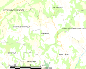
Saint-Christophe-et-le-Laris (Saint-Christophe-et-le-Laris)

- commune in Drôme, France
 Hiking in Saint-Christophe-et-le-Laris
Saint-Christophe-et-le-Laris is a picturesque commune located in the Drôme department in southeastern France. While it may not be as widely known as some larger hiking areas, it offers beautiful landscapes and opportunities for outdoor activities in a serene environment.
Hiking Opportunities
-
Scenic Trails: The area is characterized by charming countryside, rolling hills, and woodlands. You can find various trails that will lead you through the stunning natural scenery, allowing for a peaceful hiking experience.
-
Local Nature: The region boasts a diverse range of flora and fauna. Depending on the season, you might encounter wildflowers, butterflies, and various bird species. It’s a fantastic spot for nature lovers.
-
Historical Sites: Hiking in and around Saint-Christophe-et-le-Laris could also lead you to historical sites, as the region has a rich history dating back centuries. Explore local landmarks and enjoy the cultural aspects along your hike.
-
Nearby Attractions: If you venture a bit further, the Drôme region offers extensive hiking trails, including those in the Vercors Regional Park and the Parc Naturel Régional des Baronnies Provençales, which are within driving distance and provide an array of hiking routes for all skill levels.
Tips for Hiking in Saint-Christophe-et-le-Laris
-
Trail Maps: Check local resources or visitor centers for trail maps and information on the current trail conditions. Some paths may be better marked than others.
-
Pack Essentials: Bring enough water, snacks, appropriate clothing, and a first aid kit. Weather in the region can vary, so be prepared for changes.
-
Respect Nature: Follow Leave No Trace principles. Stay on designated paths and carry out any waste you bring with you.
-
Safety: Always inform someone of your hiking plan. It's advisable to hike with a friend or group, especially on less-frequented trails.
Overall, hiking in and around Saint-Christophe-et-le-Laris can be a rewarding experience for those who appreciate nature and tranquility in a less-traveled part of France. Enjoy your adventure!
- Country:

- Postal Code: 26350
- Coordinates: 45° 12' 36" N, 5° 4' 19" E


- GPS tracks (wikiloc): [Link]
- Area: 11.35 sq km
- Population: 413
- Wikipedia en: wiki(en)
- Wikipedia: wiki(fr)
- Wikidata storage: Wikidata: Q1075710
- Wikipedia Commons Category: [Link]
- Freebase ID: [/m/03mhk56]
- GeoNames ID: Alt: [6430208]
- SIREN number: [212602981]
- BnF ID: [15253158j]
- INSEE municipality code: 26298
Shares border with regions:


Montrigaud
- commune in Drôme, France
Hiking in Montrigaud
Montrigaud is a charming commune located in the Isère department in the Auvergne-Rhône-Alpes region of southeastern France. This area offers various hiking opportunities, particularly for those looking to enjoy scenic views and natural landscapes....
- Country:
- Postal Code: 26350
- Coordinates: 45° 13' 8" N, 5° 7' 52" E
- GPS tracks (wikiloc): [Link]
- Area: 28.73 sq km
- Population: 482

Tersanne
- commune in Drôme, France
Hiking in Tersanne
Tersanne is a picturesque region in the French Alps, known for its stunning landscapes, diverse wildlife, and a variety of hiking trails catering to different skill levels. Hiking in this area offers a unique opportunity to experience the natural beauty of the Alps, from lush valleys and meandering rivers to towering mountain peaks....
- Country:
- Postal Code: 26390
- Coordinates: 45° 13' 34" N, 5° 1' 2" E
- GPS tracks (wikiloc): [Link]
- Area: 9.49 sq km
- Population: 359

Miribel
- commune in Drôme, France
Hiking in Miribel
Miribel is a picturesque commune in the Drôme department of southeastern France, surrounded by stunning landscapes that are perfect for hiking enthusiasts. The region is characterized by its rolling hills, scenic vineyards, and lush forests, making it an ideal destination for outdoor activities....
- Country:
- Postal Code: 26350
- Coordinates: 45° 11' 57" N, 5° 6' 39" E
- GPS tracks (wikiloc): [Link]
- AboveSeaLevel: 393 м m
- Area: 6.55 sq km
- Population: 298


Montchenu
- commune in Drôme, France
Hiking in Montchenu
Montchenu is a charming village located in the Drôme region of southeastern France. It offers access to beautiful natural landscapes, making it an ideal destination for hiking enthusiasts....
- Country:
- Postal Code: 26350
- Coordinates: 45° 11' 44" N, 5° 1' 55" E
- GPS tracks (wikiloc): [Link]
- Area: 16.15 sq km
- Population: 582


Hauterives
- commune in Drôme, France
Hiking in Hauterives
Hauterives is a charming village located in the Drôme department of southeastern France, known for its scenic landscapes and rich cultural heritage. While it might not be as well-known as some major hiking destinations, it offers several opportunities for those looking to explore nature and enjoy the outdoors....
- Country:
- Postal Code: 26390
- Coordinates: 45° 15' 20" N, 5° 1' 35" E
- GPS tracks (wikiloc): [Link]
- Area: 30.51 sq km
- Population: 1904


Crépol
- commune in Drôme, France
Hiking in Crépol
Crépol is a charming commune located in the Drôme department in the Auvergne-Rhône-Alpes region of France. While it may not be as famous as some of the larger hiking destinations, it offers beautiful landscapes and a peaceful environment perfect for hiking enthusiasts....
- Country:
- Postal Code: 26350
- Coordinates: 45° 10' 28" N, 5° 4' 14" E
- GPS tracks (wikiloc): [Link]
- Area: 11.42 sq km
- Population: 551


Le Grand-Serre
- commune in Drôme, France
Hiking in Le Grand-Serre
Le Grand-Serre is a beautiful hiking destination located in the French Alps, specifically in the department of Isère. This area offers stunning mountain scenery, diverse wildlife, and a variety of trails suitable for different skill levels. Here are some key points to consider when planning a hike in Le Grand-Serre:...
- Country:
- Postal Code: 26530
- Coordinates: 45° 16' 12" N, 5° 6' 12" E
- GPS tracks (wikiloc): [Link]
- Area: 24.74 sq km
- Population: 902