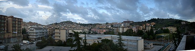
Montedoro (Montedoro)
.svg)
- Italian comune
 Hiking in Montedoro
Montedoro, located in Sicily, Italy, offers a range of hiking opportunities that cater to various skill levels and preferences. The landscape is characterized by rolling hills, olive groves, and scenic views of the surrounding countryside, providing a beautiful backdrop for outdoor activities.
Hiking Areas and Trails
-
Natural Reserves: The area may have access to natural reserves where you can find marked trails. These can vary from easy walks to more challenging hikes that lead to stunning viewpoints or historical sites.
-
Local Flora and Fauna: While hiking, you might encounter various species of wildlife and native plants, such as Mediterranean scrub, which adds to the experience of immersing yourself in nature.
-
Cultural Landmarks: Some trails may lead to local cultural heritage sites, such as ancient ruins or traditional Sicilian farms, allowing for a rich combination of outdoor activity and cultural exploration.
Tips for Hiking in Montedoro
-
Preparation: Make sure to wear appropriate footwear and clothing for the weather conditions. Even moderate hikes can involve uneven terrain.
-
Hydration: Carry plenty of water, especially during warmer months, as the Sicilian sun can be intense.
-
Navigation: Familiarize yourself with the trail maps and consider bringing a compass or GPS device, as some trails might not be well-marked.
-
Local Regulations: Always follow local regulations regarding trails and natural reserves to protect the environment.
-
Guided Tours: If you're unfamiliar with the area, consider joining a guided hiking tour to learn more about the region's flora, fauna, and history.
Hiking in Montedoro can offer a memorable experience, combining Italy's stunning natural beauty with its rich cultural heritage. Always be mindful of the local environment and hiking etiquette to enjoy your adventure safely.
- Country:

- Postal Code: 93010
- Local Dialing Code: 0934
- Licence Plate Code: CL
- Coordinates: 37° 27' 16" N, 13° 49' 1" E


- GPS tracks (wikiloc): [Link]
- AboveSeaLevel: 450 м m
- Area: 14.53 sq km
- Population: 1557
- Web site: http://www.comune.montedoro.cl.it/
- Wikipedia en: wiki(en)
- Wikipedia: wiki(it)
- Wikidata storage: Wikidata: Q477591
- Wikipedia Commons Category: [Link]
- Freebase ID: [/m/0gqgrp]
- GeoNames ID: Alt: [6537789]
- VIAF ID: Alt: [234765340]
- OSM relation ID: [39242]
- GND ID: Alt: [4461229-1]
- UN/LOCODE: [ITMD2]
- ISTAT ID: 085011
- Italian cadastre code: F489
Shares border with regions:


Canicattì
- Italian comune
Hiking in Canicattì
Canicattì, located in the southern part of Sicily, Italy, offers a unique landscape for hikers, with its rolling hills, rocky terrain, and rich cultural history. While it may not be as famous for hiking as some of the larger Sicilian destinations like Mount Etna or the Madonie Mountains, it does provide opportunities for outdoor enthusiasts looking for a more off-the-beaten-path experience....
- Country:
- Postal Code: 92024
- Local Dialing Code: 0922
- Licence Plate Code: AG
- Coordinates: 37° 21' 36" N, 13° 51' 4" E
- GPS tracks (wikiloc): [Link]
- AboveSeaLevel: 465 м m
- Area: 91.86 sq km
- Population: 35722
- Web site: [Link]


Racalmuto
- Italian comune
Hiking in Racalmuto
Racalmuto, located in Sicily, Italy, is surrounded by beautiful landscapes that are ideal for hiking enthusiasts. The terrain in and around Racalmuto features a mix of rolling hills, vineyards, and orchards, providing a variety of trails that cater to different skill levels....
- Country:
- Postal Code: 92020
- Local Dialing Code: 0922
- Licence Plate Code: AG
- Coordinates: 37° 24' 30" N, 13° 44' 5" E
- GPS tracks (wikiloc): [Link]
- AboveSeaLevel: 455 м m
- Area: 68.1 sq km
- Population: 8155
- Web site: [Link]
Bompensiere
- Italian comune
Hiking in Bompensiere
Bompensiere is a small town located in Sicily, Italy, surrounded by beautiful natural landscapes that are perfect for hiking enthusiasts. The area features various trails that range in difficulty, catering to both novice and experienced hikers....
- Country:
- Postal Code: 93010
- Local Dialing Code: 0934
- Licence Plate Code: CL
- Coordinates: 37° 28' 0" N, 13° 47' 0" E
- GPS tracks (wikiloc): [Link]
- AboveSeaLevel: 283 м m
- Area: 19.95 sq km
- Population: 553
- Web site: [Link]


Mussomeli
- Italian comune
Hiking in Mussomeli
Mussomeli, located in the province of Caltanissetta in Sicily, Italy, offers a unique hiking experience characterized by its beautiful landscapes, rich history, and diverse ecosystems. Here are some highlights and tips for hiking in and around Mussomeli:...
- Country:
- Postal Code: 93014
- Local Dialing Code: 0934
- Licence Plate Code: CL
- Coordinates: 37° 35' 0" N, 13° 45' 0" E
- GPS tracks (wikiloc): [Link]
- AboveSeaLevel: 650 м m
- Area: 164.43 sq km
- Population: 10556
- Web site: [Link]

Serradifalco
- Italian comune
Hiking in Serradifalco
Serradifalco is a small town located in Sicily, Italy, known for its beautiful landscapes and rich history. Hiking in and around Serradifalco offers a wonderful opportunity to explore the natural beauty of the Sicilian countryside, along with its cultural heritage....
- Country:
- Postal Code: 93010
- Local Dialing Code: 0934
- Licence Plate Code: CL
- Coordinates: 37° 27' 14" N, 13° 52' 50" E
- GPS tracks (wikiloc): [Link]
- AboveSeaLevel: 504 м m
- Area: 41.94 sq km
- Population: 5959
- Web site: [Link]