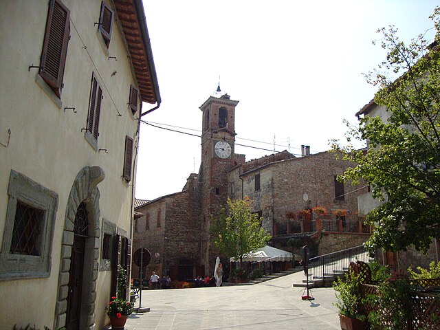
Monterchi (Monterchi)
.svg)
- Italian comune
 Hiking in Monterchi
Monterchi, a quaint village in Tuscany, Italy, offers some stunning hiking opportunities amidst rolling hills, vineyards, and picturesque landscapes. If you're planning to hike in or around Monterchi, here are some key points to consider:
Trails and Routes:
-
Sentiero della Bonifica (The Land Reclamation Trail): This trail runs through the surrounding countryside and is well-marked. It takes you through scenic farmland and offers beautiful views of the valley.
-
Monte Muro Trail: This is a moderate hike that leads you to the summit of Monte Muro, where you can enjoy panoramic views of the surrounding area, including the beautiful landscapes of Tuscany.
-
Follow Olive Groves and Vineyards: Many trails wind through olive groves and vineyards, allowing you to experience Tuscany’s rich agricultural traditions along your hike.
Highlights:
- Local Flora and Fauna: Keep an eye out for the diverse plant life and bird species that inhabit the region.
- Cultural Sites: As you hike, you may come across historical sites, including ancient churches and rural chapels, offering a glimpse into the area's rich heritage.
- Local Produce: Consider stopping by local farms or wineries for tastings of Tuscan wine and olive oil, enhancing your hiking experience.
Practical Tips:
- Best Time to Hike: Spring (April to June) and autumn (September to October) are ideal for hiking, as temperatures are mild and the scenery is particularly beautiful.
- Footwear: Wear sturdy hiking shoes, as some trails can be rocky and uneven.
- Water & Snacks: Bring plenty of water and snacks, especially if you’re planning a longer hike.
- Maps and Guides: Having a trail map or a guide can enhance your experience and help navigate the less marked paths.
Safety:
- Weather: Check the local weather conditions before heading out. Tuscany can experience sudden changes in weather.
- Navigational Tools: Consider using a GPS or hiking app to help you stay on track.
Whether you're a seasoned hiker or a beginner looking to enjoy the beauty of Tuscany, Monterchi can provide a memorable hiking experience!
- Country:

- Postal Code: 52035
- Local Dialing Code: 0575
- Licence Plate Code: AR
- Coordinates: 43° 29' 21" N, 12° 6' 44" E


- GPS tracks (wikiloc): [Link]
- AboveSeaLevel: 356 м m
- Area: 29.42 sq km
- Population: 1716
- Web site: http://www.comunemonterchi.it
- Wikipedia en: wiki(en)
- Wikipedia: wiki(it)
- Wikidata storage: Wikidata: Q52088
- Wikipedia Commons Category: [Link]
- Freebase ID: [/m/0gm08y]
- GeoNames ID: Alt: [6538590]
- VIAF ID: Alt: [129647597]
- OSM relation ID: [42453]
- WOEID: [718939]
- UN/LOCODE: [ITZOH]
- ISTAT ID: 051024
- Italian cadastre code: F594
Shares border with regions:


Arezzo
- Italian comune
Hiking in Arezzo
Arezzo, located in Tuscany, Italy, offers a diverse range of hiking opportunities amidst its stunning landscapes, charming villages, and historical landmarks. Here are some highlights and tips for hiking in the Arezzo area:...
- Country:
- Postal Code: 52100
- Local Dialing Code: 0575
- Licence Plate Code: AR
- Coordinates: 43° 27' 47" N, 11° 52' 41" E
- GPS tracks (wikiloc): [Link]
- AboveSeaLevel: 296 м m
- Area: 384.7 sq km
- Population: 99541
- Web site: [Link]
Citerna
- Italian comune
Hiking in Citerna
Citerna is a charming hilltop village located in the Umbria region of Italy, near the border with Tuscany. Known for its stunning landscapes, historical architecture, and tranquil atmosphere, it makes for a great hiking destination. Here are some key points regarding hiking in and around Citerna:...
- Country:
- Postal Code: 06010
- Local Dialing Code: 075
- Licence Plate Code: PG
- Coordinates: 43° 30' 0" N, 12° 7' 0" E
- GPS tracks (wikiloc): [Link]
- AboveSeaLevel: 480 м m
- Area: 23.53 sq km
- Population: 3463
- Web site: [Link]


Città di Castello
- Italian comune
Hiking in Città di Castello
Città di Castello, located in the Umbria region of Italy, is surrounded by stunning landscapes, making it a great destination for hiking enthusiasts. Here are some key points about hiking in and around Città di Castello:...
- Country:
- Postal Code: 06018; 06010; 06012
- Local Dialing Code: 075
- Licence Plate Code: PG
- Coordinates: 43° 27' 27" N, 12° 14' 25" E
- GPS tracks (wikiloc): [Link]
- AboveSeaLevel: 288 м m
- Area: 387.32 sq km
- Population: 39632
- Web site: [Link]


Monte Santa Maria Tiberina
- Italian comune
Hiking in Monte Santa Maria Tiberina
Monte Santa Maria Tiberina is a beautiful hilltop town located in the Umbria region of Italy, known for its stunning landscapes, rich history, and charming architecture. Hiking in this area can be a delightful experience, offering a mix of scenic views, ancient paths, and a glimpse into local culture....
- Country:
- Postal Code: 06010
- Local Dialing Code: 075
- Licence Plate Code: PG
- Coordinates: 43° 26' 14" N, 12° 9' 45" E
- GPS tracks (wikiloc): [Link]
- AboveSeaLevel: 688 м m
- Area: 72.53 sq km
- Population: 1156
- Web site: [Link]


Anghiari
- Italian comune
Hiking in Anghiari
Anghiari is a charming medieval town located in the Tuscany region of Italy, known for its stunning landscapes, rich history, and well-preserved architecture. Hiking in and around Anghiari offers a variety of trails that showcase the beautiful countryside, rolling hills, and picturesque views unique to this part of Tuscany....
- Country:
- Postal Code: 52031
- Local Dialing Code: 0575
- Licence Plate Code: AR
- Coordinates: 43° 32' 30" N, 12° 3' 18" E
- GPS tracks (wikiloc): [Link]
- AboveSeaLevel: 429 м m
- Area: 130.92 sq km
- Population: 5536
- Web site: [Link]