Montesson (Montesson)

- commune in Yvelines, France
- Country:

- Postal Code: 78360
- Coordinates: 48° 54' 31" N, 2° 8' 58" E


- GPS tracks (wikiloc): [Link]
- AboveSeaLevel: 56 м m
- Area: 7.36 sq km
- Population: 15145
- Web site: http://www.montesson.fr
- Wikipedia en: wiki(en)
- Wikipedia: wiki(fr)
- Wikidata storage: Wikidata: Q830293
- Wikipedia Commons Category: [Link]
- Freebase ID: [/m/02rzdb_]
- Freebase ID: [/m/02rzdb_]
- GeoNames ID: Alt: [2992650]
- GeoNames ID: Alt: [2992650]
- SIREN number: [217804186]
- SIREN number: [217804186]
- BnF ID: [15276041p]
- BnF ID: [15276041p]
- VIAF ID: Alt: [237847424]
- VIAF ID: Alt: [237847424]
- Quora topic ID: [Montesson]
- Quora topic ID: [Montesson]
- INSEE municipality code: 78418
- INSEE municipality code: 78418
Shares border with regions:

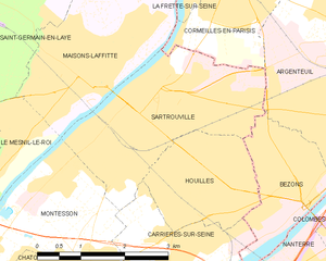
Sartrouville
- commune in Yvelines, France
- Country:
- Postal Code: 78500
- Coordinates: 48° 56' 43" N, 2° 10' 12" E
- GPS tracks (wikiloc): [Link]
- Area: 8.46 sq km
- Population: 52538
- Web site: [Link]

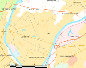
Chatou
- commune in Yvelines, France
- Country:
- Postal Code: 78400
- Coordinates: 48° 53' 26" N, 2° 9' 25" E
- GPS tracks (wikiloc): [Link]
- Area: 5.08 sq km
- Population: 31058
- Web site: [Link]


Le Pecq
- commune in Yvelines, France
- Country:
- Postal Code: 78230
- Coordinates: 48° 53' 48" N, 2° 6' 22" E
- GPS tracks (wikiloc): [Link]
- Area: 2.84 sq km
- Population: 16131
- Web site: [Link]

Carrières-sur-Seine
- commune in Yvelines, France
- Country:
- Postal Code: 78420
- Coordinates: 48° 54' 29" N, 2° 10' 41" E
- GPS tracks (wikiloc): [Link]
- Area: 5.02 sq km
- Population: 15197
- Web site: [Link]


Le Vésinet
- commune in Yvelines, France
- Country:
- Postal Code: 78110
- Coordinates: 48° 53' 38" N, 2° 7' 56" E
- GPS tracks (wikiloc): [Link]
- Area: 5 sq km
- Population: 15884
- Web site: [Link]


Le Mesnil-le-Roi
- commune in Yvelines, France
- Country:
- Postal Code: 78600
- Coordinates: 48° 55' 41" N, 2° 7' 21" E
- GPS tracks (wikiloc): [Link]
- AboveSeaLevel: 42 м m
- Area: 3.25 sq km
- Population: 6303
- Web site: [Link]