Monteu da Po (Monteu da Po)

- Italian comune
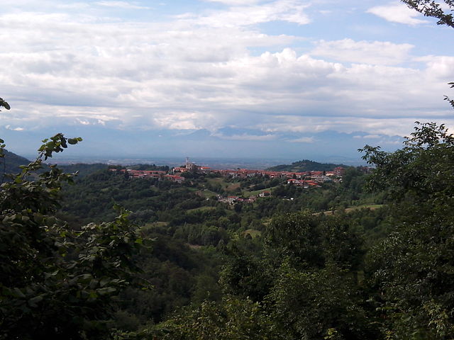
 Hiking in Monteu da Po
Monteu da Po, located in the Piedmont region of Italy, is a charming destination for hikers and outdoor enthusiasts. This small municipality is nestled in the foothills of the Alps and offers various hiking trails that showcase its stunning natural beauty and diverse landscapes.
Hiking Opportunities:
-
Scenic Trails: Monteu da Po features a range of trails, varying in difficulty, that wind through lush forests, rolling hills, and picturesque valleys. You can find well-marked paths that are suitable for both novice and experienced hikers.
-
Nature Walks: The area is rich in biodiversity, so you might encounter various flora and fauna as you hike. Be on the lookout for native plant species and wildlife, including birds and small mammals.
-
Historical Routes: Some trails may also have historical significance, leading to old churches, castles, or ruins that are part of the region's cultural heritage.
-
Panoramic Views: Many of the trails in Monteu da Po provide breathtaking panoramic views of the surrounding landscape, including the Alps on clear days.
Tips for Hiking in Monteu da Po:
- Preparation: Make sure to wear appropriate footwear and clothing, as trail conditions can vary. Bring water, snacks, and a map or GPS device, as some trails might not have cell service.
- Weather Check: Always check the weather forecast before starting your hike, as conditions can change rapidly in mountainous areas.
- Respect Nature: Follow the Leave No Trace principles. Stay on marked trails, pack out what you bring in, and be mindful of wildlife.
- Local Guidance: If you're unfamiliar with the area, consider hiring a local guide who can provide insights into the trails and help ensure a safe hiking experience.
Nearby Attractions:
- Castles and Monuments: Consider exploring nearby historical sites, enhancing your hiking experience with a touch of culture.
- Local Cuisine: After your hike, indulge in the local cuisine at restaurants or trattorias to recharge after a long day on the trails.
Whether you're looking for a leisurely walk in nature or a challenging hike, Monteu da Po offers an excellent opportunity to enjoy the outdoors while soaking in the stunning Italian landscape.
- Country:

- Postal Code: 10020
- Local Dialing Code: 011
- Licence Plate Code: TO
- Coordinates: 45° 11' 0" N, 7° 58' 0" E


- GPS tracks (wikiloc): [Link]
- AboveSeaLevel: 177 м m
- Area: 7.39 sq km
- Population: 905
- Web site: http://www.comune.monteudapo.to.it/
- Wikipedia en: wiki(en)
- Wikipedia: wiki(it)
- Wikidata storage: Wikidata: Q9493
- Wikipedia Commons Category: [Link]
- Freebase ID: [/m/0cbdd7]
- GeoNames ID: Alt: [6538067]
- VIAF ID: Alt: [304911279]
- OSM relation ID: [44398]
- TGN ID: [7052777]
- ISTAT ID: 001162
- Italian cadastre code: F651
Shares border with regions:


Verolengo
- Italian comune
Hiking in Verolengo
Verolengo is a delightful destination for hiking enthusiasts, located in the Piedmont region of northern Italy. Nestled along the banks of the River Po, this charming town offers scenic landscapes, historical sites, and a taste of rural Italian culture....
- Country:
- Postal Code: 10038
- Local Dialing Code: 011
- Licence Plate Code: TO
- Coordinates: 45° 11' 0" N, 7° 58' 0" E
- GPS tracks (wikiloc): [Link]
- AboveSeaLevel: 169 м m
- Area: 29.49 sq km
- Population: 4854
- Web site: [Link]


Brusasco
- Italian comune
Hiking in Brusasco
Brusasco is a charming town located in the Piedmont region of Italy, known for its rich history and beautiful natural surroundings. While it might not be as famous as other trekking destinations, it offers several opportunities for hiking enthusiasts to explore its scenic landscapes and cultural heritage....
- Country:
- Postal Code: 10020
- Local Dialing Code: 011
- Licence Plate Code: TO
- Coordinates: 45° 9' 0" N, 8° 4' 0" E
- GPS tracks (wikiloc): [Link]
- AboveSeaLevel: 170 м m
- Area: 14.36 sq km
- Population: 1554
- Web site: [Link]


Cavagnolo
- Italian comune
Hiking in Cavagnolo
Cavagnolo, located in the Piedmont region of Italy, offers some beautiful hiking opportunities with picturesque landscapes and a combination of cultural and natural attractions. While it may not be a well-known hiking destination compared to some of the nearby larger parks or mountains, it still provides scenic routes and trails suitable for various skill levels....
- Country:
- Postal Code: 10020
- Local Dialing Code: 011
- Licence Plate Code: TO
- Coordinates: 45° 9' 6" N, 8° 2' 57" E
- GPS tracks (wikiloc): [Link]
- AboveSeaLevel: 155 м m
- Area: 12.33 sq km
- Population: 2114
- Web site: [Link]

Lauriano
- Italian comune
Hiking in Lauriano
Lauriano is a charming municipality located in the Piedmont region of Italy, known for its beautiful landscapes and outdoor opportunities. While it's a smaller town, it offers access to a range of hiking trails that allow you to explore the surrounding countryside, including vineyards, rolling hills, and scenic views of the nearby Alps....
- Country:
- Postal Code: 10020
- Local Dialing Code: 011
- Licence Plate Code: TO
- Coordinates: 45° 10' 0" N, 8° 0' 0" E
- GPS tracks (wikiloc): [Link]
- AboveSeaLevel: 175 м m
- Area: 14.29 sq km
- Population: 1452
- Web site: [Link]