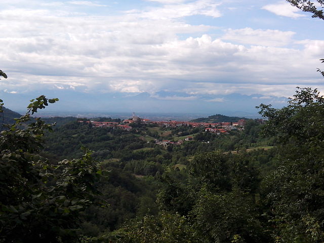
Verolengo (Verolengo)

- Italian comune
 Hiking in Verolengo
Verolengo is a delightful destination for hiking enthusiasts, located in the Piedmont region of northern Italy. Nestled along the banks of the River Po, this charming town offers scenic landscapes, historical sites, and a taste of rural Italian culture.
Hiking Trails
-
River Po Trails: There are several walking paths along the banks of the River Po. These trails often offer flat, leisurely walks where you can enjoy views of the river, local wildlife, and the surrounding countryside.
-
Surrounding Hills: The area around Verolengo features rolling hills that provide more challenging hikes. Trails in these areas can lead you through vineyards, orchards, and natural reserves, presenting opportunities for both exploration and photography.
-
Nature Reserves: Nearby nature reserves, such as the Parco del Po, offer a network of trails that let you experience the local flora and fauna. It's a great spot for birdwatching and appreciating the biodiversity of the region.
Tips for Hiking in Verolengo
- Seasonal Considerations: Spring and autumn are ideal seasons for hiking, as the weather is mild and pleasant.
- Local Guidance: Consider reaching out to local hiking groups or tourism offices for guided hikes or maps of the trails.
- Preparation: Always wear appropriate footwear and clothing, bring plenty of water, and carry a map or GPS device, especially if you venture into less marked areas.
- Respect Nature: As with any outdoor activity, be respectful of wildlife and follow Leave No Trace principles.
Cultural Highlights
While hiking, take the time to explore Verolengo itself. The town has beautiful architecture and quaint streets. You may encounter historical sites like local churches or fountains that add to the charm of the area.
Conclusion
Verolengo offers a unique blend of scenic hikes and cultural experiences. Whether you’re an experienced hiker or just looking for a leisurely stroll, this area of Piedmont has something to offer every nature lover. Enjoy your hike!
- Country:

- Postal Code: 10038
- Local Dialing Code: 011
- Licence Plate Code: TO
- Coordinates: 45° 11' 0" N, 7° 58' 0" E


- GPS tracks (wikiloc): [Link]
- AboveSeaLevel: 169 м m
- Area: 29.49 sq km
- Population: 4854
- Web site: http://www.comuneverolengo.it/
- Wikipedia en: wiki(en)
- Wikipedia: wiki(it)
- Wikidata storage: Wikidata: Q10343
- Wikipedia Commons Category: [Link]
Shares border with regions:
Rondissone
- Italian comune
Hiking in Rondissone
Rondissone is a small town located in the Piedmont region of Italy, near Turin. While it may not be as well-known for hiking as some larger mountain regions in Italy, there are opportunities for outdoor activities in the surrounding countryside....
- Country:
- Postal Code: 10030
- Local Dialing Code: 011
- Licence Plate Code: TO
- Coordinates: 45° 15' 0" N, 7° 58' 0" E
- GPS tracks (wikiloc): [Link]
- AboveSeaLevel: 211 м m
- Area: 10.69 sq km
- Population: 1881
- Web site: [Link]


San Sebastiano da Po
- Italian comune
Hiking in San Sebastiano da Po
San Sebastiano da Po is a charming town located in the Piemonte region of Italy, close to Turin. It is surrounded by beautiful landscapes that are ideal for hiking enthusiasts. Here are some key points to consider if you’re planning a hiking trip in this area:...
- Country:
- Postal Code: 10020
- Local Dialing Code: 011
- Licence Plate Code: TO
- Coordinates: 45° 11' 0" N, 7° 58' 0" E
- GPS tracks (wikiloc): [Link]
- AboveSeaLevel: 175 м m
- Area: 16.58 sq km
- Population: 1945
- Web site: [Link]


Torrazza Piemonte
- Italian comune
Hiking in Torrazza Piemonte
Torrazza Piemonte is a small town located in the province of Turin in the Piedmont region of Italy. While it may not be as widely known for hiking as some of the larger national parks or mountainous areas in Italy, there are still opportunities for outdoor enthusiasts to explore the picturesque landscapes of the surrounding area....
- Country:
- Postal Code: 10037
- Local Dialing Code: 011
- Licence Plate Code: TO
- Coordinates: 45° 13' 0" N, 7° 58' 0" E
- GPS tracks (wikiloc): [Link]
- AboveSeaLevel: 197 м m
- Area: 9.82 sq km
- Population: 2906
- Web site: [Link]

Crescentino
- Italian comune
Hiking in Crescentino
Crescentino, located in the Piedmont region of Italy, is not primarily known as a hiking destination, but that does not mean there aren't opportunities for outdoor activities in the surrounding areas. Here are some key points to consider for hiking in and around Crescentino:...
- Country:
- Postal Code: 13044
- Local Dialing Code: 0161
- Licence Plate Code: VC
- Coordinates: 45° 11' 0" N, 8° 6' 0" E
- GPS tracks (wikiloc): [Link]
- AboveSeaLevel: 154 м m
- Area: 48.22 sq km
- Population: 7814
- Web site: [Link]

Saluggia
- Italian comune
Hiking in Saluggia
Saluggia is a small town located in the Piedmont region of northern Italy, near the banks of the Po River. While it may not be as widely recognized as a hiking destination compared to other parts of Italy, it does offer access to beautiful landscapes and trails, particularly in the surrounding areas....
- Country:
- Postal Code: 13040
- Local Dialing Code: 0161
- Licence Plate Code: VC
- Coordinates: 45° 14' 0" N, 8° 1' 0" E
- GPS tracks (wikiloc): [Link]
- AboveSeaLevel: 194 м m
- Area: 31.6 sq km
- Population: 4030
- Web site: [Link]


Brusasco
- Italian comune
Hiking in Brusasco
Brusasco is a charming town located in the Piedmont region of Italy, known for its rich history and beautiful natural surroundings. While it might not be as famous as other trekking destinations, it offers several opportunities for hiking enthusiasts to explore its scenic landscapes and cultural heritage....
- Country:
- Postal Code: 10020
- Local Dialing Code: 011
- Licence Plate Code: TO
- Coordinates: 45° 9' 0" N, 8° 4' 0" E
- GPS tracks (wikiloc): [Link]
- AboveSeaLevel: 170 м m
- Area: 14.36 sq km
- Population: 1554
- Web site: [Link]


Chivasso
- Italian comune
Hiking in Chivasso
Chivasso, a town located in the Piedmont region of Italy, offers some beautiful landscapes and opportunities for outdoor activities, including hiking. While Chivasso itself is more urban, it serves as a good starting point for exploring the surrounding natural areas, particularly the Po River Park and nearby hills....
- Country:
- Postal Code: 10034
- Local Dialing Code: 011
- Licence Plate Code: TO
- Coordinates: 45° 11' 0" N, 7° 53' 0" E
- GPS tracks (wikiloc): [Link]
- AboveSeaLevel: 183 м m
- Area: 51.24 sq km
- Population: 26976
- Web site: [Link]

Lauriano
- Italian comune
Hiking in Lauriano
Lauriano is a charming municipality located in the Piedmont region of Italy, known for its beautiful landscapes and outdoor opportunities. While it's a smaller town, it offers access to a range of hiking trails that allow you to explore the surrounding countryside, including vineyards, rolling hills, and scenic views of the nearby Alps....
- Country:
- Postal Code: 10020
- Local Dialing Code: 011
- Licence Plate Code: TO
- Coordinates: 45° 10' 0" N, 8° 0' 0" E
- GPS tracks (wikiloc): [Link]
- AboveSeaLevel: 175 м m
- Area: 14.29 sq km
- Population: 1452
- Web site: [Link]

Monteu da Po
- Italian comune
Hiking in Monteu da Po
Monteu da Po, located in the Piedmont region of Italy, is a charming destination for hikers and outdoor enthusiasts. This small municipality is nestled in the foothills of the Alps and offers various hiking trails that showcase its stunning natural beauty and diverse landscapes....
- Country:
- Postal Code: 10020
- Local Dialing Code: 011
- Licence Plate Code: TO
- Coordinates: 45° 11' 0" N, 7° 58' 0" E
- GPS tracks (wikiloc): [Link]
- AboveSeaLevel: 177 м m
- Area: 7.39 sq km
- Population: 905
- Web site: [Link]