Montjay (Montjay)

- commune in Saône-et-Loire, France
- Country:

- Postal Code: 71310
- Coordinates: 46° 48' 25" N, 5° 18' 36" E


- GPS tracks (wikiloc): [Link]
- Area: 11.03 sq km
- Population: 199
- Wikipedia en: wiki(en)
- Wikipedia: wiki(fr)
- Wikidata storage: Wikidata: Q842818
- Wikipedia Commons Category: [Link]
- Wikipedia Commons Maps Category: [Link]
- Freebase ID: [/m/03qh0vr]
- Freebase ID: [/m/03qh0vr]
- GeoNames ID: Alt: [6442334]
- GeoNames ID: Alt: [6442334]
- SIREN number: [217103142]
- SIREN number: [217103142]
- BnF ID: [152732854]
- BnF ID: [152732854]
- INSEE municipality code: 71314
- INSEE municipality code: 71314
Shares border with regions:


Chapelle-Voland
- commune in Jura, France
- Country:
- Postal Code: 39140
- Coordinates: 46° 48' 11" N, 5° 22' 41" E
- GPS tracks (wikiloc): [Link]
- Area: 30.5 sq km
- Population: 615

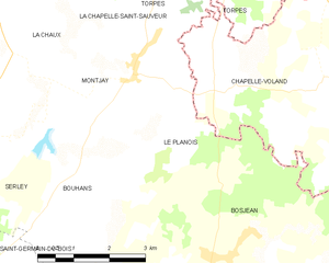
Le Planois
- commune in Saône-et-Loire, France
- Country:
- Postal Code: 71330
- Coordinates: 46° 47' 15" N, 5° 19' 38" E
- GPS tracks (wikiloc): [Link]
- Area: 5.17 sq km
- Population: 100


Bouhans
- commune in Saône-et-Loire, France
- Country:
- Postal Code: 71330
- Coordinates: 46° 46' 23" N, 5° 17' 43" E
- GPS tracks (wikiloc): [Link]
- Area: 10.21 sq km
- Population: 165


La Chaux
- commune in Saône-et-Loire, France
- Country:
- Postal Code: 71310
- Coordinates: 46° 49' 41" N, 5° 15' 36" E
- GPS tracks (wikiloc): [Link]
- Area: 11 sq km
- Population: 307


La Chapelle-Saint-Sauveur
- commune in Saône-et-Loire, France
- Country:
- Postal Code: 71310
- Coordinates: 46° 50' 37" N, 5° 16' 7" E
- GPS tracks (wikiloc): [Link]
- Area: 27.36 sq km
- Population: 676

Torpes
- commune in Saône-et-Loire, France
- Country:
- Postal Code: 71270
- Coordinates: 46° 50' 30" N, 5° 20' 18" E
- GPS tracks (wikiloc): [Link]
- Area: 15.7 sq km
- Population: 383