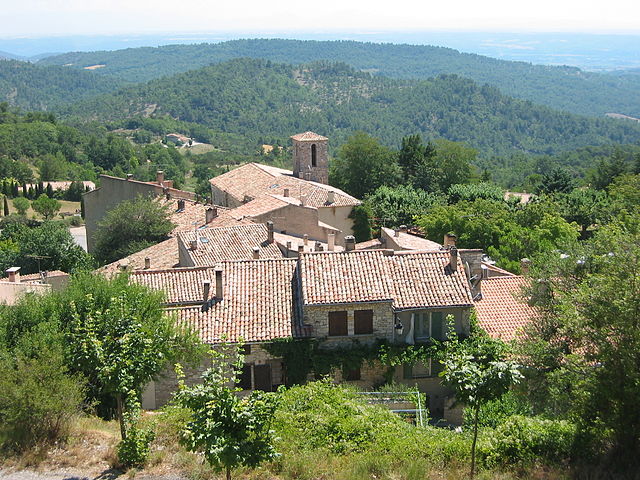
Montjustin (Montjustin)
- commune in Alpes-de-Haute-Provence, France
 Hiking in Montjustin
Montjustin is a charming village in the Provence-Alpes-Côte d'Azur region of France, nestled in the picturesque landscapes of the Luberon area. The region is known for its stunning natural beauty, quaint villages, and rich history, making it a wonderful destination for hiking enthusiasts.
Hiking Opportunities
-
Scenic Trails: The trails around Montjustin offer a variety of scenic routes, ranging from easy walks to more challenging hikes. Many paths take you through lush fields, forests, and vineyards, providing stunning views of the surrounding hills and valleys.
-
Luberon Regional Nature Park: Montjustin is located near the Luberon Regional Nature Park, which features numerous trails that cater to hikers of all levels. You can explore the park’s stunning landscapes, unique rock formations, and diverse flora and fauna.
-
Historical and Cultural Sites: As you hike, you may come across historical landmarks, including old stone houses, ruins, and churches that showcase the region's rich heritage. The quaint architecture and the charm of villages add an extra layer to the hiking experience.
-
Flora and Fauna: The region is home to a variety of plants and animals, making it a great spot for nature lovers. Keep an eye out for local wildlife and the stunning wildflowers that bloom in the spring.
Tips for Hiking in Montjustin
- Footwear: Wear sturdy hiking boots or shoes with good traction, as some trails may be rocky or uneven.
- Hydration: Always carry enough water, especially during the warmer months when temperatures can rise.
- Weather: Check the weather forecast before setting out as conditions can change quickly, particularly in mountainous areas.
- Maps and Signage: Having a good map or a GPS app can be helpful, as while many paths are marked, some may not be well signposted.
- Respect Nature: Follow Leave No Trace principles by sticking to trails, packing out what you bring in, and being mindful of wildlife.
Local Attractions
- Nearby Villages: Consider exploring nearby villages like Simiane-la-Rotonde and Roussillon, known for their beautiful landscapes and vibrant local culture.
- Dining: After a day of hiking, enjoy local cuisine in Montjustin or nearby areas, where you can taste traditional Provençal dishes.
Overall, hiking in Montjustin offers a wonderful blend of adventure, natural beauty, and cultural experiences, making it an ideal spot for both casual walkers and experienced hikers.
- Country:

- Postal Code: 04110
- Coordinates: 43° 50' 57" N, 5° 38' 5" E


- GPS tracks (wikiloc): [Link]
- Area: 10.15 sq km
- Population: 56
- Wikipedia en: wiki(en)
- Wikipedia: wiki(fr)
- Wikidata storage: Wikidata: Q1093072
- Wikipedia Commons Category: [Link]
- Freebase ID: [/m/03m7wz1]
- Freebase ID: [/m/03m7wz1]
- GeoNames ID: Alt: [2992337]
- GeoNames ID: Alt: [2992337]
- SIREN number: [210401295]
- SIREN number: [210401295]
- PACTOLS thesaurus ID: [pcrtgP8ljeqzFO]
- PACTOLS thesaurus ID: [pcrtgP8ljeqzFO]
- INSEE municipality code: 04129
- INSEE municipality code: 04129
Shares border with regions:

Reillanne
- commune in Alpes-de-Haute-Provence, France
Hiking in Reillanne
Reillanne, a charming village in the Luberon region of Provence, France, offers a delightful hiking experience set against a backdrop of stunning landscapes, vineyards, and olive groves. Here are some highlights and tips for hiking in and around Reillanne:...
- Country:
- Postal Code: 04110
- Coordinates: 43° 52' 45" N, 5° 39' 33" E
- GPS tracks (wikiloc): [Link]
- Area: 38.55 sq km
- Population: 1621

Villemus
- commune in Alpes-de-Haute-Provence, France
Hiking in Villemus
Villemus, a small commune in the Provence-Alpes-Côte d'Azur region of France, is known for its stunning landscapes and beautiful natural surroundings, making it a great destination for hiking enthusiasts. Here are some aspects to consider for hiking in and around Villemus:...
- Country:
- Postal Code: 04110
- Coordinates: 43° 51' 33" N, 5° 42' 3" E
- GPS tracks (wikiloc): [Link]
- AboveSeaLevel: 436 м m
- Area: 9.59 sq km
- Population: 181
Montfuron
- commune in Alpes-de-Haute-Provence, France
Hiking in Montfuron
Montfuron is a charming village located in the Vaucluse department of southeastern France, nestled in the heart of the Provence region. The area around Montfuron offers beautiful landscapes, making it an attractive destination for hikers and nature enthusiasts....
- Country:
- Postal Code: 04110
- Coordinates: 43° 50' 9" N, 5° 41' 38" E
- GPS tracks (wikiloc): [Link]
- Area: 18.88 sq km
- Population: 214


La Bastide-des-Jourdans
- commune in Vaucluse, France
Hiking in La Bastide-des-Jourdans
La Bastide-des-Jourdans is a charming village located in the Provence-Alpes-Côte d'Azur region of southern France, known for its beautiful landscapes, vineyards, and rich history. Hiking in this area offers a great opportunity to explore the stunning natural surroundings and enjoy the peaceful rural ambiance....
- Country:
- Postal Code: 84240
- Coordinates: 43° 47' 7" N, 5° 38' 4" E
- GPS tracks (wikiloc): [Link]
- Area: 27.74 sq km
- Population: 1448

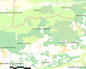
Vitrolles-en-Luberon
- commune in Vaucluse, France
Hiking in Vitrolles-en-Luberon
Vitrolles-en-Luberon is a charming village located in the heart of the Luberon Regional Nature Park in Provence, France. The region is known for its stunning landscapes, rich biodiversity, and picturesque trails that cater to hikers of varying skill levels....
- Country:
- Postal Code: 84240
- Coordinates: 43° 48' 40" N, 5° 35' 43" E
- GPS tracks (wikiloc): [Link]
- Area: 16.15 sq km
- Population: 200

Céreste
- commune in Alpes-de-Haute-Provence, France
Hiking in Céreste
Céreste is a charming village located in the Provence region of southeastern France, nestled in the Luberon mountains. It offers a variety of hiking opportunities that showcase the stunning natural beauty and rich cultural heritage of the area....
- Country:
- Postal Code: 04280
- Coordinates: 43° 51' 21" N, 5° 35' 14" E
- GPS tracks (wikiloc): [Link]
- Area: 32.54 sq km
- Population: 1194