Montfuron (Montfuron)
- commune in Alpes-de-Haute-Provence, France
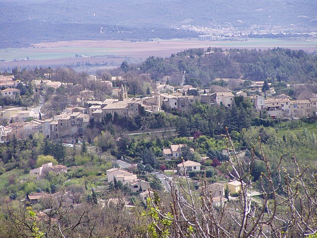
Montfuron is a charming village located in the Vaucluse department of southeastern France, nestled in the heart of the Provence region. The area around Montfuron offers beautiful landscapes, making it an attractive destination for hikers and nature enthusiasts.
Hiking Trails and Features:
-
Scenic Views: The hikes around Montfuron provide stunning panoramic views of the Luberon mountains, vineyards, and picturesque countryside. The landscape is characterized by rolling hills, olive groves, and lavender fields, especially vibrant in late spring and summer.
-
Varied Difficulty: There are various trails suitable for all skill levels, from easy walks for families to more challenging hikes for experienced trekkers. You can find well-marked paths ideal for leisurely strolls or longer treks.
-
Natural Environment: The area is rich in biodiversity. While hiking, keep an eye out for local wildlife, including birds, rabbits, and a variety of native plants. The surrounding forests and hills provide a habitat for many species and add to the tranquility of your hike.
-
Cultural Trails: Some trails may lead you through historical sites and landmarks, giving you a taste of the local culture and history. You might pass through ancient stone villages and ruins that tell the story of the region.
-
Seasonal Hiking: The best times for hiking in Montfuron typically range from spring (April to June) to early fall (September to October) when the weather is mild. Summer can be hot, so it's advisable to start early in the day or choose shaded paths if you hike during this time.
Preparation Tips:
- Gear: Wear sturdy, comfortable hiking shoes and bring plenty of water, snacks, and sun protection (hat, sunscreen).
- Navigation: While many trails are well-marked, it's a good idea to have a map of the area or a GPS device. Some trails might not be as well-maintained, so being prepared is important.
- Respect Nature: Follow Leave No Trace principles to preserve the natural beauty of the area. Stay on marked trails to protect local flora and fauna.
Getting There:
Montfuron is accessible by car, and parking can often be found near trailheads. Public transportation options may be limited, so driving is usually the most convenient way to reach the area.
Enjoy your hiking adventure in Montfuron, and immerse yourself in the natural beauty and cultural richness of Provence!
- Country:

- Postal Code: 04110
- Coordinates: 43° 50' 9" N, 5° 41' 38" E


- GPS tracks (wikiloc): [Link]
- Area: 18.88 sq km
- Population: 214
- Wikipedia en: wiki(en)
- Wikipedia: wiki(fr)
- Wikidata storage: Wikidata: Q1018635
- Wikipedia Commons Category: [Link]
- Freebase ID: [/m/03m7wyq]
- Freebase ID: [/m/03m7wyq]
- GeoNames ID: Alt: [2992574]
- GeoNames ID: Alt: [2992574]
- SIREN number: [210401287]
- SIREN number: [210401287]
- Trismegistos Geo ID: [21642]
- Trismegistos Geo ID: [21642]
- INSEE municipality code: 04128
- INSEE municipality code: 04128
Shares border with regions:

Villemus
- commune in Alpes-de-Haute-Provence, France
Villemus, a small commune in the Provence-Alpes-Côte d'Azur region of France, is known for its stunning landscapes and beautiful natural surroundings, making it a great destination for hiking enthusiasts. Here are some aspects to consider for hiking in and around Villemus:...
- Country:

- Postal Code: 04110
- Coordinates: 43° 51' 33" N, 5° 42' 3" E


- GPS tracks (wikiloc): [Link]
- AboveSeaLevel: 436 м m
- Area: 9.59 sq km
- Population: 181

Pierrevert
- commune in Alpes-de-Haute-Provence, France
Pierrevert, located in the picturesque region of Provence-Alpes-Côte d'Azur in France, offers a variety of hiking opportunities set against the backdrop of beautiful landscapes, rolling hills, and Mediterranean vegetation. Here are some key highlights for hiking in Pierrevert:...
- Country:

- Postal Code: 04860
- Coordinates: 43° 48' 41" N, 5° 44' 58" E


- GPS tracks (wikiloc): [Link]
- Area: 27.9 sq km
- Population: 3672
- Web site: [Link]

Montjustin
- commune in Alpes-de-Haute-Provence, France
Montjustin is a charming village in the Provence-Alpes-Côte d'Azur region of France, nestled in the picturesque landscapes of the Luberon area. The region is known for its stunning natural beauty, quaint villages, and rich history, making it a wonderful destination for hiking enthusiasts....
- Country:

- Postal Code: 04110
- Coordinates: 43° 50' 57" N, 5° 38' 5" E


- GPS tracks (wikiloc): [Link]
- Area: 10.15 sq km
- Population: 56

Manosque
- commune in Alpes-de-Haute-Provence, France
Manosque, located in the Provence-Alpes-Côte d'Azur region of southeastern France, is surrounded by stunning natural landscapes, making it a fantastic destination for hiking enthusiasts. The area is characterized by its rolling hills, forests, and picturesque villages, offering a variety of trails suitable for different skill levels. Here’s what you need to know about hiking in and around Manosque:...
- Country:

- Postal Code: 04100
- Coordinates: 43° 50' 0" N, 5° 46' 59" E


- GPS tracks (wikiloc): [Link]
- Area: 56.73 sq km
- Population: 21754
- Web site: [Link]


La Bastide-des-Jourdans
- commune in Vaucluse, France
 Hiking in La Bastide-des-Jourdans
La Bastide-des-Jourdans is a charming village located in the Provence-Alpes-Côte d'Azur region of southern France, known for its beautiful landscapes, vineyards, and rich history. Hiking in this area offers a great opportunity to explore the stunning natural surroundings and enjoy the peaceful rural ambiance....
- Country:

- Postal Code: 84240
- Coordinates: 43° 47' 7" N, 5° 38' 4" E


- GPS tracks (wikiloc): [Link]
- Area: 27.74 sq km
- Population: 1448