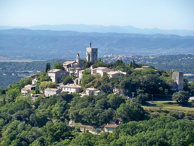
Montségur-sur-Lauzon (Montségur-sur-Lauzon)
- commune in Drôme, France
 Hiking in Montségur-sur-Lauzon
Montségur-sur-Lauzon is a charming village located in the Drôme department of the Auvergne-Rhône-Alpes region in southeastern France. It offers a variety of hiking opportunities amidst stunning natural scenery, including vineyards, aromatic fields, and the picturesque landscapes of the surrounding hills.
Key Hiking Highlights in Montségur-sur-Lauzon:
-
Scenic Trails: The area is characterized by a network of well-marked hiking paths that cater to various skill levels, from easy strolls to more challenging hikes. The trails often provide breathtaking views of the Rhône Valley and the surrounding mountains.
-
Vineyard Paths: One popular hiking route takes you through the local vineyards, where you can enjoy the lush landscapes and perhaps even stop for some wine tasting at nearby producers.
-
Nature and Wildlife: The region is rich in biodiversity, so keep an eye out for local flora and fauna. The diverse ecosystems include dry scrublands, rich woodlands, and cultivated land.
-
Historical Sites: While hiking, you may come across remnants of historical sites, including churches, old farmhouses, and other quaint architecture that tells the story of the region's past.
-
Family-Friendly Routes: There are trails suitable for families and beginners, making it an ideal location for those hiking with children or looking for a leisurely outdoor experience.
-
Seasonal Considerations: Spring and fall are particularly beautiful times to hike in Montségur-sur-Lauzon, as the weather is mild, and the scenery is vibrant with blooming flowers or fall foliage.
-
Local Guides: If you're new to the area, consider hiring a local guide who can provide insights into the region's ecology, history, and culture, enhancing your hiking experience.
Tips for Hiking in Montségur-sur-Lauzon:
- Safety: Always check trail conditions, especially after rain, and consider the level of difficulty suitable for your group.
- Stay Hydrated: Bring enough water, as some trails may not have facilities.
- Dress Appropriately: Wear comfortable hiking shoes and dress layers, as temperatures can change quickly.
- Respect Nature: Follow Leave No Trace principles to preserve the beauty of the area.
Montségur-sur-Lauzon is a beautiful destination for hiking, blending stunning scenery with a peaceful, rural atmosphere that allows for an enjoyable outdoor experience.
- Country:

- Postal Code: 26130
- Coordinates: 44° 21' 38" N, 4° 51' 34" E


- GPS tracks (wikiloc): [Link]
- Area: 18.24 sq km
- Population: 1268
- Wikipedia en: wiki(en)
- Wikipedia: wiki(fr)
- Wikidata storage: Wikidata: Q468233
- Wikipedia Commons Category: [Link]
- Freebase ID: [/m/03mgjtd]
- Freebase ID: [/m/03mgjtd]
- GeoNames ID: Alt: [2991970]
- GeoNames ID: Alt: [2991970]
- SIREN number: [212602114]
- SIREN number: [212602114]
- BnF ID: [15253072t]
- BnF ID: [15253072t]
- WOEID: [613126]
- WOEID: [613126]
- INSEE municipality code: 26211
- INSEE municipality code: 26211
Shares border with regions:


Richerenches
- commune in Vaucluse, France
Richerenches is a small commune located in the Vaucluse department in the Provence-Alpes-Côte d'Azur region of southeastern France. Known for its picturesque landscapes, charming historic buildings, and proximity to natural areas, it's a great place for hiking enthusiasts....
- Country:

- Postal Code: 84600
- Coordinates: 44° 21' 34" N, 4° 54' 45" E


- GPS tracks (wikiloc): [Link]
- Area: 10.96 sq km
- Population: 672
- Web site: [Link]


Solérieux
- commune in Drôme, France
- Country:

- Postal Code: 26130
- Coordinates: 44° 20' 54" N, 4° 49' 55" E


- GPS tracks (wikiloc): [Link]
- Area: 8.55 sq km
- Population: 334


Clansayes
- commune in Drôme, France
- Country:

- Postal Code: 26130
- Coordinates: 44° 22' 16" N, 4° 48' 27" E


- GPS tracks (wikiloc): [Link]
- Area: 14.47 sq km
- Population: 516


Chamaret
- commune in Drôme, France
Chamaret is a charming village located in the Drôme department of southeastern France, known for its picturesque landscapes and proximity to vineyards and the stunning countryside of the Rhône-Alpes region. Hiking in and around Chamaret offers a unique experience, showcasing both natural beauty and local culture....
- Country:

- Postal Code: 26230
- Coordinates: 44° 23' 47" N, 4° 52' 58" E


- GPS tracks (wikiloc): [Link]
- Area: 7.79 sq km
- Population: 576


La Baume-de-Transit
- commune in Drôme, France
La Baume-de-Transit is a charming village located in the Drôme department of southeastern France. It's surrounded by beautiful landscapes, making it an excellent destination for hiking enthusiasts. The area boasts a mix of gentle hills, vineyards, and is near the picturesque Rhône Valley, providing various trails suitable for different skill levels....
- Country:

- Postal Code: 26790
- Coordinates: 44° 20' 18" N, 4° 51' 56" E


- GPS tracks (wikiloc): [Link]
- Area: 12.05 sq km
- Population: 855


Colonzelle
- commune in Drôme, France
Colonzelle is a small commune located in the Drôme department in the Auvergne-Rhône-Alpes region of southeastern France. It is surrounded by beautiful natural landscapes, making it a great place for hiking enthusiasts. Here are some highlights about hiking in and around Colonzelle:...
- Country:

- Postal Code: 26230
- Coordinates: 44° 23' 35" N, 4° 54' 2" E


- GPS tracks (wikiloc): [Link]
- Area: 6.06 sq km
- Population: 529


Chantemerle-lès-Grignan
- commune in Drôme, France
 Hiking in Chantemerle-lès-Grignan
Chantemerle-lès-Grignan is a picturesque village located in the Drôme department of the Auvergne-Rhône-Alpes region of southeastern France. Its proximity to the stunning landscapes of the Provence region makes it an enticing destination for hikers. Here’s what you should know about hiking in this area:...
- Country:

- Postal Code: 26230
- Coordinates: 44° 24' 11" N, 4° 50' 8" E


- GPS tracks (wikiloc): [Link]
- Area: 9.82 sq km
- Population: 271
