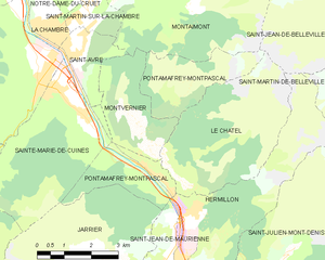
Montvernier (Montvernier)

- commune in Savoie, France
 Hiking in Montvernier
Montvernier, located in the Savoie region of the French Alps, is a hidden gem for hikers. The area is renowned for its stunning landscapes, featuring charming alpine villages, lush valleys, and breathtaking mountain views. Here are some key points to consider if you’re planning a hiking trip in Montvernier:
Trails
- Diverse Options: Montvernier offers a variety of trails suitable for different skill levels, from leisurely walks to more challenging mountain paths.
- Breathtaking Views: Many trails provide panoramic views of the surrounding peaks and valleys, particularly the Alps and the neighboring town of Saint-Jean-de-Maurienne.
Highlights
- Alpine Flora and Fauna: The region is rich in biodiversity, so keep an eye out for local wildlife and unique alpine plants along your hike.
- Cultural Stops: You can explore the quaint villages along the trails, where you may encounter traditional Savoyard architecture and local gastronomy.
Practical Information
- Best Time to Visit: The hiking season typically runs from late spring to early fall. Summer is ideal for wildflower viewing, while autumn offers vibrant fall colors.
- Weather: Always check weather conditions before heading out, as weather in the mountains can change rapidly.
Safety Tips
- Prepare Adequately: Bring enough water, snacks, and proper gear, such as sturdy hiking boots and weather-appropriate clothing.
- Map and Compass: Although many trails are marked, having a map and knowledge of how to read it is beneficial, especially on less-traveled paths.
Getting There
- Access: Montvernier is accessible by road, and the nearest major cities with transportation links are Lyon and Chambéry. It's advisable to have a car for convenience in reaching trailheads.
Conclusion
Montvernier offers a unique hiking experience with its combination of natural beauty and cultural heritage. Whether you're an experienced hiker or just looking for a lovely day out in the mountains, Montvernier is sure to impress. Remember to leave no trace and respect the natural environment as you enjoy your hike!
- Country:

- Postal Code: 73300
- Coordinates: 45° 19' 17" N, 6° 20' 36" E


- GPS tracks (wikiloc): [Link]
- Area: 6.68 sq km
- Population: 223
- Wikipedia en: wiki(en)
- Wikipedia: wiki(fr)
- Wikidata storage: Wikidata: Q570737
- Wikipedia Commons Category: [Link]
- Freebase ID: [/m/03npf61]
- GeoNames ID: Alt: [6442835]
- SIREN number: [217301779]
- BnF ID: [152741090]
- INSEE municipality code: 73177
Shares border with regions:

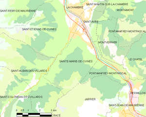
Pontamafrey-Montpascal
- commune in Savoie, France
Hiking in Pontamafrey-Montpascal
Pontamafrey-Montpascal is a scenic area in the Savoie region of France, known for its beautiful landscapes, diverse trails, and rich natural flora and fauna. While specific trails can vary, here are some general guidelines and tips for hiking in this region:...
- Country:
- Postal Code: 73300
- Coordinates: 45° 18' 45" N, 6° 20' 29" E
- GPS tracks (wikiloc): [Link]
- Area: 11.59 sq km
- Population: 312
- Web site: [Link]


Montaimont
- former commune in Savoie, France
Hiking in Montaimont
Montaimont is a charming commune in the Savoie department of the Auvergne-Rhône-Alpes region in southeastern France. Nestled in the Alps, it offers stunning natural landscapes and a variety of hiking opportunities, making it an excellent destination for outdoor enthusiasts....
- Country:
- Postal Code: 73130
- Coordinates: 45° 22' 17" N, 6° 20' 49" E
- GPS tracks (wikiloc): [Link]
- Area: 28.35 sq km
- Population: 157
- Web site: [Link]
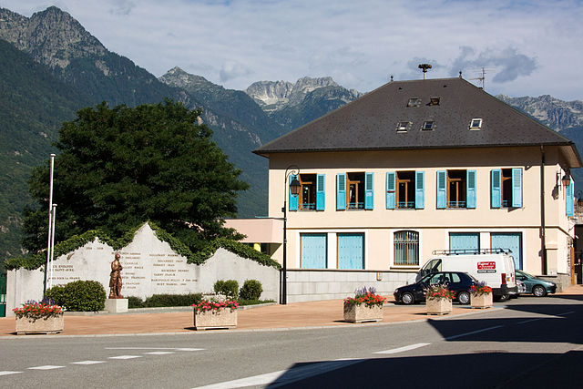

Saint-Avre
- commune in Savoie, France
Hiking in Saint-Avre
Saint-Avre is a charming commune located in the Savoie region of the French Alps. Nestled in a picturesque valley, it offers a variety of hiking opportunities that cater to different skill levels and preferences. Here are some key points to consider for hiking in and around Saint-Avre:...
- Country:
- Postal Code: 73130
- Coordinates: 45° 21' 9" N, 6° 18' 36" E
- GPS tracks (wikiloc): [Link]
- Area: 3.64 sq km
- Population: 868


Le Châtel
- commune in Savoie, France
Hiking in Le Châtel
Le Châtel, a picturesque area located in the French Alps, offers a variety of hiking opportunities suited for different skill levels. It's a less crowded destination compared to some of the more famous Alpine regions, making it a great choice for those seeking tranquility and natural beauty....
- Country:
- Postal Code: 73300
- Coordinates: 45° 18' 25" N, 6° 21' 32" E
- GPS tracks (wikiloc): [Link]
- Area: 15.31 sq km
- Population: 195
- Web site: [Link]

Sainte-Marie-de-Cuines
- commune in Savoie, France
Hiking in Sainte-Marie-de-Cuines
Sainte-Marie-de-Cuines is a beautiful destination for hiking enthusiasts, nestled in the Auvergne-Rhône-Alpes region of France, specifically in Savoie. The area offers breathtaking landscapes, from rolling hills to the majestic alpine terrain, making it ideal for various hiking levels. Here are some highlights and tips for hiking in this region:...
- Country:
- Postal Code: 73130
- Coordinates: 45° 20' 24" N, 6° 18' 6" E
- GPS tracks (wikiloc): [Link]
- Area: 14.95 sq km
- Population: 812
- Web site: [Link]