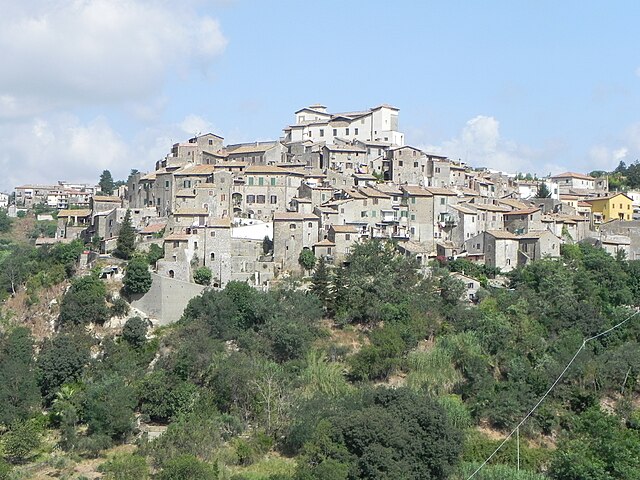
Morlupo (Morlupo)
.svg)
- Italian comune
 Hiking in Morlupo
Morlupo is a picturesque town located in the Lazio region of Italy, near Rome. It is surrounded by beautiful natural landscapes, making it a great spot for hiking enthusiasts. Here are some key points to consider when hiking in and around Morlupo:
Scenic Trails
- Natural Beauty: The area around Morlupo features hills, valleys, and a mix of wooded areas and open fields, offering diverse scenery.
- Historical Paths: Many trails may lead to ancient ruins, historical sites, or charming villages nearby, enriching your hiking experience with cultural exploration.
- Wildlife: The region is home to various species of flora and fauna, giving you a chance to observe local wildlife, especially in protected areas.
Popular Hiking Routes
- Monte Soratte: A short drive from Morlupo, this mountain offers several trails with varying difficulty levels. The trails lead to the summit, where you can enjoy panoramic views of the surrounding countryside.
- Parco Regionale di Veio: This regional park is situated near Morlupo and has numerous well-marked hiking paths that reflect the natural beauty of the area.
Hiking Tips
- Best Time to Go: Spring and fall are ideal for hiking with mild weather and beautiful scenery. Summer can be hot, while winter may bring snow to higher elevations.
- Gear: Wear sturdy hiking boots, and bring plenty of water, snacks, and a first-aid kit. Depending on the trails, trekking poles might also be helpful.
- Local Maps: It’s advisable to have a good map or a hiking app on your phone as trail signage may be limited in some areas.
- Respect Nature: Follow Leave No Trace principles — take your trash with you, stay on marked trails, and respect wildlife.
Safety Considerations
- Always inform someone of your hiking plans and expected return time.
- Be aware of local weather conditions and prepare accordingly.
- If you plan to hike in more remote areas, consider going with a group or hiring a local guide.
Hiking around Morlupo can provide a fantastic mix of nature, history, and adventure, making it a worthwhile experience for outdoor enthusiasts!
- Country:

- Postal Code: 00067
- Local Dialing Code: 06
- Licence Plate Code: RM
- Coordinates: 42° 8' 36" N, 12° 30' 17" E


- GPS tracks (wikiloc): [Link]
- AboveSeaLevel: 207 м m
- Area: 24.08 sq km
- Population: 8689
- Web site: http://www.comune.morlupo.roma.it
- Wikipedia en: wiki(en)
- Wikipedia: wiki(it)
- Wikidata storage: Wikidata: Q243022
- Wikipedia Commons Gallery: [Link]
- Wikipedia Commons Category: [Link]
- Freebase ID: [/m/0gm7sq]
- GeoNames ID: Alt: [6540523]
- OSM relation ID: [41810]
- Digital Atlas of the Roman Empire ID: [17248]
- Pleiades ID: [412998]
- ISTAT ID: 058068
- Italian cadastre code: F734
Shares border with regions:


Capena
- Italian comune
Hiking in Capena
Capena is a charming town located in the Lazio region of Italy, close to Rome, and offers several hiking opportunities for both beginners and experienced hikers. The surrounding area features a mix of natural beauty and historical significance, making it an attractive destination for outdoor enthusiasts....
- Country:
- Postal Code: 00060
- Local Dialing Code: 06
- Licence Plate Code: ROMA
- Coordinates: 42° 8' 25" N, 12° 32' 25" E
- GPS tracks (wikiloc): [Link]
- AboveSeaLevel: 160 м m
- Area: 29.51 sq km
- Population: 10799
- Web site: [Link]

Castelnuovo di Porto
- Italian comune
Hiking in Castelnuovo di Porto
Castelnuovo di Porto, located in the Lazio region of Italy, offers a variety of beautiful hiking opportunities that showcase the region's natural beauty and history. Nestled between the Tiber River and the hills of the Sabina region, the area is characterized by its picturesque landscapes, rolling hills, and charming medieval architecture....
- Country:
- Postal Code: 00060
- Local Dialing Code: 06
- Licence Plate Code: ROMA
- Coordinates: 42° 7' 40" N, 12° 30' 0" E
- GPS tracks (wikiloc): [Link]
- AboveSeaLevel: 250 м m
- Area: 30.57 sq km
- Population: 8564
- Web site: [Link]
Magliano Romano
- Italian comune
Hiking in Magliano Romano
Magliano Romano, located in the Lazio region of Italy, is a charming medieval town that offers some wonderful hiking opportunities. Nestled in the Sabine Hills, it is surrounded by natural beauty, including rolling hills, forests, and picturesque landscapes. Here’s what you might consider when planning a hiking trip in the area:...
- Country:
- Postal Code: 00060
- Local Dialing Code: 06
- Licence Plate Code: RM
- Coordinates: 42° 9' 36" N, 12° 26' 9" E
- GPS tracks (wikiloc): [Link]
- AboveSeaLevel: 270 м m
- Area: 20.52 sq km
- Population: 1397
- Web site: [Link]


Rignano Flaminio
- Italian comune
Hiking in Rignano Flaminio
Rignano Flaminio is a charming town located in the Lazio region of Italy, just north of Rome. This area is known for its beautiful landscapes, rich history, and proximity to the Tiber River, making it a great destination for hiking enthusiasts....
- Country:
- Postal Code: 00068
- Local Dialing Code: 0761
- Licence Plate Code: ROMA
- Coordinates: 42° 12' 0" N, 12° 29' 0" E
- GPS tracks (wikiloc): [Link]
- AboveSeaLevel: 250 м m
- Area: 38.56 sq km
- Population: 10328
- Web site: [Link]