Mosnang (Mosnang)
- municipality in Switzerland
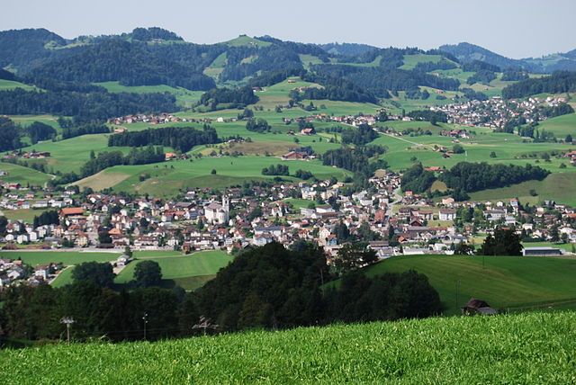
Mosnang is a municipality located in the canton of St. Gallen in Switzerland, known for its beautiful landscapes and outdoor recreational opportunities, including hiking. Here are some key points for those interested in hiking in the Mosnang area:
Scenic Trails
-
Variety of Trails: Mosnang offers a variety of hiking trails ranging from easy walks suitable for families to more challenging hikes for experienced trekkers. The trails often lead through picturesque landscapes, including lush forests, rolling hills, and panoramic views of the Toggenburg region.
-
Marked Paths: The trails are well-marked with signposts, and many feature information boards that describe the local flora and fauna, as well as historical context. This makes it easy to navigate and enhances the hiking experience.
-
Nature Experience: Hiking in Mosnang allows visitors to immerse themselves in nature. You might encounter diverse wildlife, beautiful meadows, and serene streams, making it a great destination for nature lovers and photographers.
Accessibility
- Public Transport: The area is generally accessible via public transport, making it easy to start your hike without needing to drive. Look for local train or bus schedules for convenient access.
Seasonal Considerations
-
Best Time to Visit: The best time for hiking in Mosnang is typically during the spring and summer months when the trails are clear of snow, and the weather is pleasant. Autumn can also offer beautiful scenery as the leaves change color.
-
Winter Hiking: In the winter, some trails may be suitable for snowshoeing or winter hiking with the appropriate gear.
Local Amenities
-
Accommodations: Mosnang may offer local accommodations, including guesthouses and hotels for those who wish to stay overnight and explore the area more thoroughly.
-
Food and Drink: Some trails might lead to traditional Swiss restaurants or mountain huts where you can rest and enjoy local cuisine.
Safety Tips
-
Preparation: Always check the weather conditions before heading out and dress in layers. Bring sufficient water, snacks, and a map or GPS device for navigation.
-
Group Hiking: If you are unfamiliar with the area, consider hiking with a group or a guide for safety.
Hiking in Mosnang can be a rewarding experience, allowing you to enjoy Switzerland's stunning natural beauty while getting some physical activity. Enjoy your adventure!
- Country:

- Postal Code: 9607
- Local Dialing Code: 071
- Licence Plate Code: SG
- Coordinates: 47° 21' 0" N, 9° 1' 59" E


- GPS tracks (wikiloc): [Link]
- AboveSeaLevel: 735 м m
- Area: 50.46 sq km
- Population: 2884
- Web site: http://www.mosnang.ch
- Wikipedia en: wiki(en)
- Wikipedia: wiki(de)
- Wikidata storage: Wikidata: Q65775
- Wikipedia Commons Category: [Link]
- Freebase ID: [/m/0gprkn]
- GeoNames ID: Alt: [7286562]
- VIAF ID: Alt: [145646996]
- OSM relation ID: [1683907]
- archINFORM location ID: [12760]
- Library of Congress authority ID: Alt: [n2008049696]
- HDS ID: [1391]
- Swiss municipality code: [3394]
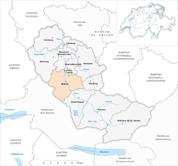
Shares border with regions:


Kirchberg
- municipality in the canton of St. Gallen, Switzerland
Kirchberg, located in the Canton of St. Gallen, Switzerland, is a beautiful area known for its scenic landscapes and outdoor recreational opportunities. While the region is less known than some of the more touristic spots in Switzerland, it offers several delightful hiking trails that cater to different skill levels....
- Country:

- Postal Code: 9533
- Local Dialing Code: 071
- Licence Plate Code: SG
- Coordinates: 47° 24' 30" N, 9° 1' 34" E


- GPS tracks (wikiloc): [Link]
- AboveSeaLevel: 723 м m
- Area: 42.59 sq km
- Population: 9016
- Web site: [Link]


Fischingen
- municipality in the canton of Thurgau, Switzerland
Fischingen is a picturesque village located in the canton of Thurgau in Switzerland, surrounded by beautiful landscapes that are perfect for hiking enthusiasts. The area is characterized by rolling hills, lush forests, and serene lakes, making it a fantastic destination for both casual walkers and serious hikers....
- Country:

- Postal Code: 8376
- Local Dialing Code: 071
- Licence Plate Code: TG
- Coordinates: 47° 24' 59" N, 8° 58' 0" E


- GPS tracks (wikiloc): [Link]
- AboveSeaLevel: 625 м m
- Area: 30.7 sq km
- Population: 2695
- Web site: [Link]


Bütschwil
- former municipality of Switzerland in St. Gallen
Bütschwil is a picturesque village located in the Canton of St. Gallen, Switzerland. It offers a range of hiking opportunities amidst stunning landscapes, rolling hills, and lush greenery. Here are some highlights for hiking in Bütschwil:...
- Country:

- Postal Code: 9606
- Local Dialing Code: 071
- Licence Plate Code: SG
- Coordinates: 47° 20' 59" N, 9° 4' 0" E


- GPS tracks (wikiloc): [Link]
- AboveSeaLevel: 610 м m
- Area: 13.79 sq km
- Web site: [Link]


Wattwil
- municipality in the canton of St. Gallen, Switzerland
Wattwil, located in the Canton of St. Gallen in Switzerland, is a charming town surrounded by stunning landscapes, making it an excellent base for hiking enthusiasts. The region offers a variety of trails that cater to different skill levels, from easy walks to more challenging hikes....
- Country:

- Postal Code: 9630
- Local Dialing Code: 071
- Licence Plate Code: SG
- Coordinates: 47° 17' 58" N, 9° 5' 8" E


- GPS tracks (wikiloc): [Link]
- AboveSeaLevel: 610 м m
- Area: 51.25 sq km
- Population: 8713
- Web site: [Link]


Sternenberg
- former municipality of Switzerland
Sternenberg is an attractive destination for hiking enthusiasts, located in the beautiful region of Switzerland. Here are some key points to consider if you're exploring the area:...
- Country:

- Postal Code: 8499
- Local Dialing Code: 052
- Licence Plate Code: ZH
- Coordinates: 47° 23' 0" N, 8° 55' 0" E


- GPS tracks (wikiloc): [Link]
- AboveSeaLevel: 869 м m
- Area: 8.75 sq km
- Web site: [Link]


Eschenbach
- municipality in the canton of St. Gallen, Switzerland
Eschenbach, located in the canton of St. Gallen in Switzerland, is a charming village surrounded by beautiful landscapes, making it a fantastic destination for hiking enthusiasts. Here are some aspects to consider if you're planning a hike in this region:...
- Country:

- Postal Code: 8733
- Local Dialing Code: 055
- Licence Plate Code: SG
- Coordinates: 47° 16' 15" N, 8° 58' 12" E


- GPS tracks (wikiloc): [Link]
- AboveSeaLevel: 763 м m
- Area: 54.82 sq km
- Population: 9477
- Web site: [Link]


Lütisburg
- municipality in Switzerland
Lütisburg is a charming area located in the canton of St. Gallen, Switzerland, known for its beautiful landscapes, rolling hills, and scenic trails. Hiking in Lütisburg offers a unique experience with a mix of nature, tranquility, and stunning views of the surrounding countryside and the Alps....
- Country:

- Postal Code: 9604
- Local Dialing Code: 071
- Licence Plate Code: SG
- Coordinates: 47° 23' 41" N, 9° 4' 52" E


- GPS tracks (wikiloc): [Link]
- AboveSeaLevel: 580 м m
- Area: 14.09 sq km
- Population: 1565
- Web site: [Link]

