Mouthier-Haute-Pierre (Mouthier-Haute-Pierre)

- commune in Doubs, France
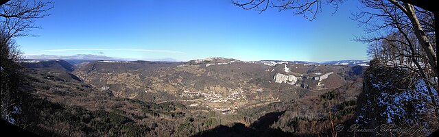
 Hiking in Mouthier-Haute-Pierre
Mouthier-Haute-Pierre is a picturesque village nestled in the Jura Mountains of eastern France. It's known for its beautiful natural landscapes, making it a fantastic destination for hiking enthusiasts. Here are some highlights and tips for hiking in the area:
Trails and Nature
-
Variety of Trails: The region around Mouthier-Haute-Pierre features a range of hiking trails suitable for various fitness levels, from easy walks to challenging hikes. The trails often provide stunning views of the surrounding mountains, forests, and rivers.
-
Le Doubs River: One of the notable landmarks is the Doubs River, which carves its way through the valley, offering scenic views and opportunities for hikes that follow the riverbank or explore nearby gorges.
-
Flora and Fauna: The Jura Mountains are rich in biodiversity. You may encounter diverse flora, including beech and fir forests, as well as a variety of wildlife, such as deer and numerous bird species.
Recommendations
- Maps and Guides: Before setting out, it's a good idea to obtain a map of the local hiking trails or use a reliable hiking app to navigate the area.
- Stay Hydrated and Pack Snacks: Bring enough water and energy snacks, especially for longer hikes, as facilities may be limited on the trails.
- Weather Preparedness: The weather can change quickly in the mountains, so dress in layers and be prepared for rain or cooler temperatures, even during the summer months.
Local Attractions
- Cascades de la Douvè: This waterfall is a nice addition to your hike, and nearby trails lead to beautiful spots for picnicking and relaxing by the water.
- Château de Mouthier: This historic site may be of interest to those looking to combine a bit of culture with their adventure.
Hiking Season
- Best Time to Visit: The best time for hiking in this area generally falls between spring and fall (April to October), when the weather is milder, and the trails are more accessible. However, winter hiking can also be rewarding if you're well-prepared for snow and colder conditions.
By embracing the natural beauty of Mouthier-Haute-Pierre and preparing adequately, your hiking experience can be both exhilarating and memorable. Enjoy your outdoor adventure!
- Country:

- Postal Code: 25920
- Coordinates: 47° 2' 20" N, 6° 16' 33" E


- GPS tracks (wikiloc): [Link]
- Area: 12.13 sq km
- Population: 320
- Web site: http://mouthier-haute-pierre.fr
- Wikipedia en: wiki(en)
- Wikipedia: wiki(fr)
- Wikidata storage: Wikidata: Q906701
- Wikipedia Commons Category: [Link]
- Freebase ID: [/m/03mgxvx]
- Freebase ID: [/m/03mgxvx]
- GeoNames ID: Alt: [2991331]
- GeoNames ID: Alt: [2991331]
- SIREN number: [212504153]
- SIREN number: [212504153]
- BnF ID: [15252641z]
- BnF ID: [15252641z]
- INSEE municipality code: 25415
- INSEE municipality code: 25415
Shares border with regions:


Évillers
- commune in Doubs, France
Hiking in Évillers
Évillers is a charming commune located in the Doubs department of the Bourgogne-Franche-Comté region in eastern France. It is surrounded by beautiful natural landscapes, making it an ideal destination for hiking enthusiasts....
- Country:
- Postal Code: 25520
- Coordinates: 47° 0' 0" N, 6° 13' 33" E
- GPS tracks (wikiloc): [Link]
- Area: 13.02 sq km
- Population: 346


Athose
- former commune in Doubs, France
Hiking in Athose
Hiking in Athos, a peninsula in northern Greece, is a unique experience shaped by its rich history, stunning landscapes, and spiritual significance. Mount Athos is home to a number of Eastern Orthodox monasteries and is known as a monastic community, meaning that only men are permitted to visit. Here are some key points to consider when hiking in this area:...
- Country:
- Postal Code: 25580
- Coordinates: 47° 4' 39" N, 6° 18' 34" E
- GPS tracks (wikiloc): [Link]
- Area: 7.63 sq km
- Population: 188

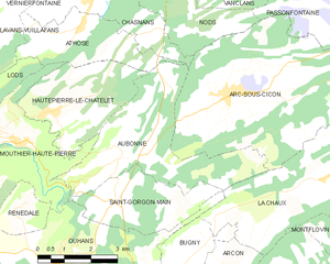
Aubonne
- commune in Doubs, France
Hiking in Aubonne
Aubonne, located in the Doubs department of France, offers a serene environment perfect for hiking enthusiasts. The region is characterized by its stunning landscapes, including hilly terrains, dense forests, and picturesque views of the surrounding countryside....
- Country:
- Postal Code: 25520
- Coordinates: 47° 2' 10" N, 6° 19' 43" E
- GPS tracks (wikiloc): [Link]
- Area: 15.17 sq km
- Population: 239


Ouhans
- commune in Doubs, France
Hiking in Ouhans
Ouhans is a charming village located in the Franche-Comté region of France, surrounded by the stunning landscapes of the Jura Mountains. This area offers a variety of hiking opportunities suitable for different skill levels, making it a great destination for hikers....
- Country:
- Postal Code: 25520
- Coordinates: 46° 59' 54" N, 6° 17' 37" E
- GPS tracks (wikiloc): [Link]
- Area: 15.85 sq km
- Population: 373


Hautepierre-le-Châtelet
- former commune in Doubs, France
Hiking in Hautepierre-le-Châtelet
Hautepierre-le-Châtelet is a small commune located in the Vosges region of northeastern France. This area is known for its scenic landscapes, rich flora and fauna, and a variety of hiking opportunities. Here are some points to consider if you're planning to hike in Hautepierre-le-Châtelet:...
- Country:
- Postal Code: 25580
- Coordinates: 47° 2' 54" N, 6° 17' 18" E
- GPS tracks (wikiloc): [Link]
- AboveSeaLevel: 790 м m
- Area: 9.61 sq km
- Population: 111
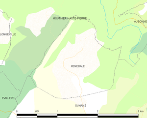
Renédale
- commune in Doubs, France
Hiking in Renédale
Renédale is not a well-known hiking destination, and I don't have specific information about it as of my last update in October 2023. However, if there's a location called Renédale that has emerged or gained popularity recently, you might want to check local hiking guides, websites, or social media for the latest information and trail reviews....
- Country:
- Postal Code: 25520
- Coordinates: 47° 1' 4" N, 6° 16' 39" E
- GPS tracks (wikiloc): [Link]
- Area: 2.88 sq km
- Population: 41


Lods
- commune in Doubs, France
Hiking in Lods
Lodz, Poland, is not traditionally renowned for hiking in the way some mountainous regions are, but it does offer unique opportunities for outdoor activities and exploring nature. The area surrounding Lodz features a mix of urban parks, forests, and trails that can cater to walkers and casual hikers. Here are some options for enjoying the outdoors around Lodz:...
- Country:
- Postal Code: 25930
- Coordinates: 47° 2' 42" N, 6° 14' 53" E
- GPS tracks (wikiloc): [Link]
- Area: 6.25 sq km
- Population: 224
- Web site: [Link]


Longeville
- commune in Doubs, France
Hiking in Longeville
Longeville is a charming commune in the Vosges department of the Grand Est region of France, known for its natural beauty and hiking opportunities. Here are some key points to consider when planning a hiking trip in and around Longeville:...
- Country:
- Postal Code: 25330
- Coordinates: 47° 1' 52" N, 6° 13' 40" E
- GPS tracks (wikiloc): [Link]
- Area: 9.46 sq km
- Population: 168