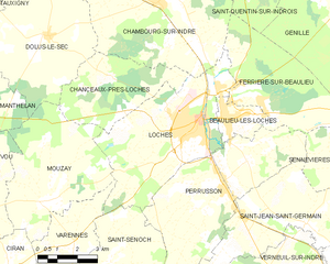
Mouzay (Mouzay)

- commune in Indre-et-Loire, France
- Country:

- Postal Code: 37600
- Coordinates: 47° 5' 22" N, 0° 53' 33" E


- GPS tracks (wikiloc): [Link]
- Area: 23.71 sq km
- Population: 479
- Wikipedia en: wiki(en)
- Wikipedia: wiki(fr)
- Wikidata storage: Wikidata: Q1172023
- Wikipedia Commons Category: [Link]
- Freebase ID: [/m/03nvfwy]
- GeoNames ID: Alt: [6433064]
- SIREN number: [213701626]
- BnF ID: [152577136]
- VIAF ID: Alt: [200046439]
- SUDOC authorities ID: [115969160]
- INSEE municipality code: 37162
Shares border with regions:


Dolus-le-Sec
- commune in Indre-et-Loire, France
- Country:
- Postal Code: 37310
- Coordinates: 47° 9' 53" N, 0° 53' 34" E
- GPS tracks (wikiloc): [Link]
- Area: 27.27 sq km
- Population: 668


Ciran
- commune in Indre-et-Loire, France
- Country:
- Postal Code: 37240
- Coordinates: 47° 3' 35" N, 0° 52' 21" E
- GPS tracks (wikiloc): [Link]
- Area: 13.86 sq km
- Population: 425
Chanceaux-près-Loches
- commune in Indre-et-Loire, France
- Country:
- Postal Code: 37600
- Coordinates: 47° 8' 49" N, 0° 56' 17" E
- GPS tracks (wikiloc): [Link]
- Area: 14.58 sq km
- Population: 136


Varennes
- commune in Indre-et-Loire, France
- Country:
- Postal Code: 37600
- Coordinates: 47° 4' 10" N, 0° 54' 57" E
- GPS tracks (wikiloc): [Link]
- Area: 11.07 sq km
- Population: 247

Loches
- commune in Indre-et-Loire, France
- Country:
- Postal Code: 37600
- Coordinates: 47° 7' 43" N, 0° 59' 43" E
- GPS tracks (wikiloc): [Link]
- AboveSeaLevel: 64 м m
- Area: 27.06 sq km
- Population: 6299
- Web site: [Link]

Vou
- commune in Indre-et-Loire, France
- Country:
- Postal Code: 37240
- Coordinates: 47° 5' 7" N, 0° 51' 33" E
- GPS tracks (wikiloc): [Link]
- Area: 21.95 sq km
- Population: 203


Manthelan
- commune in Indre-et-Loire, France
- Country:
- Postal Code: 37240
- Coordinates: 47° 8' 8" N, 0° 47' 35" E
- GPS tracks (wikiloc): [Link]
- Area: 39.58 sq km
- Population: 1385
- Web site: [Link]