Murols (Murols)

- commune in Aveyron, France
- Country:

- Postal Code: 12600
- Coordinates: 44° 45' 17" N, 2° 34' 35" E


- GPS tracks (wikiloc): [Link]
- Area: 13.9 sq km
- Population: 110
- Wikipedia en: wiki(en)
- Wikipedia: wiki(fr)
- Wikidata storage: Wikidata: Q592136
- Wikipedia Commons Category: [Link]
- Freebase ID: [/m/03m94r_]
- GeoNames ID: Alt: [6426978]
- SIREN number: [211201660]
- BnF ID: [15247142x]
- INSEE municipality code: 12166
Shares border with regions:


Taussac
- commune in Aveyron, France
- Country:
- Postal Code: 12600
- Coordinates: 44° 49' 44" N, 2° 38' 31" E
- GPS tracks (wikiloc): [Link]
- Area: 39.3 sq km
- Population: 488
- Web site: [Link]
Vezels-Roussy
- commune in Cantal, France
- Country:
- Postal Code: 15130
- Coordinates: 44° 48' 32" N, 2° 35' 7" E
- GPS tracks (wikiloc): [Link]
- Area: 12.87 sq km
- Population: 138

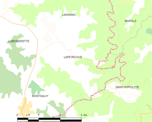
Lapeyrugue
- commune in Cantal, France
- Country:
- Postal Code: 15120
- Coordinates: 44° 43' 43" N, 2° 32' 35" E
- GPS tracks (wikiloc): [Link]
- Area: 8.47 sq km
- Population: 110

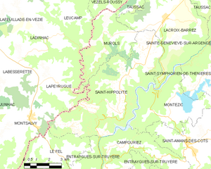
Saint-Hippolyte
- commune in Aveyron, France
- Country:
- Postal Code: 12140
- Coordinates: 44° 42' 40" N, 2° 35' 30" E
- GPS tracks (wikiloc): [Link]
- Area: 36.87 sq km
- Population: 451
- Web site: [Link]

Lacroix-Barrez
- commune in Aveyron, France
- Country:
- Postal Code: 12600
- Coordinates: 44° 46' 37" N, 2° 38' 10" E
- GPS tracks (wikiloc): [Link]
- Area: 28.01 sq km
- Population: 489
- Web site: [Link]
Leucamp
- commune in Cantal, France
- Country:
- Postal Code: 15120
- Coordinates: 44° 46' 43" N, 2° 31' 56" E
- GPS tracks (wikiloc): [Link]
- Area: 13.5 sq km
- Population: 235


Ladinhac
- commune in Cantal, France
- Country:
- Postal Code: 15120
- Coordinates: 44° 45' 18" N, 2° 30' 30" E
- GPS tracks (wikiloc): [Link]
- Area: 26.72 sq km
- Population: 481
- Web site: [Link]