Nerola (Nerola)
.svg)
- Italian comune
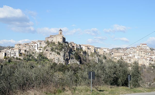
 Hiking in Nerola
Nerola is a charming town located in the Lazio region of Italy, known for its picturesque landscapes and historical significance. While it may not be as famous as some other hiking destinations in Italy, it offers several opportunities for outdoor enthusiasts to explore nature and enjoy scenic views.
Hiking Trails
-
Nature Trails: The area around Nerola features various natural trails that wind through woodlands and along picturesque hills. These trails can vary in difficulty, making them suitable for both beginners and experienced hikers.
-
Historical Routes: You can also find paths that take you to historical sites, including old churches and ruins. This type of hike allows you to enjoy both nature and the rich history of the region.
-
Regional Parks: Nearby parks, such as the Monti Lucretili Regional Park, provide a broader selection of hiking routes. This park is known for its diverse flora and fauna, along with panoramic views from higher elevations.
Prepare for Your Hike
- Weather: Check the weather conditions before you go. The best times to hike in this region are typically in the spring and autumn, when the temperatures are moderate.
- Gear: Wear appropriate hiking boots and clothing. Bring plenty of water, snacks, and a first-aid kit.
- Maps: It's helpful to have a map or a GPS app if you’re exploring off the beaten path. Local tourist information centers can often provide trail maps and insights.
Safety Tips
- Inform someone about your hike, especially if you’re going on a longer trail.
- Stay on marked trails to protect the environment and ensure your safety.
- Be aware of wildlife and know what to do if you encounter animals.
Conclusion
Nerola offers a beautiful setting for hiking amidst nature and history. Whether you're looking for a leisurely stroll or a more vigorous hike, there are opportunities to explore the natural beauty of this area. Enjoy your hiking adventure in Nerola!
- Country:

- Postal Code: 00017
- Local Dialing Code: 0774
- Licence Plate Code: RM
- Coordinates: 42° 10' 0" N, 12° 47' 0" E


- GPS tracks (wikiloc): [Link]
- AboveSeaLevel: 453 м m
- Area: 17.1 sq km
- Population: 1969
- Web site: http://www.comunenerola.it/
- Wikipedia en: wiki(en)
- Wikipedia: wiki(it)
- Wikidata storage: Wikidata: Q243109
- Wikipedia Commons Gallery: [Link]
- Wikipedia Commons Category: [Link]
- Freebase ID: [/m/0btfym]
- GeoNames ID: Alt: [6538684]
- VIAF ID: Alt: [242699119]
- OSM relation ID: [41819]
- ISTAT ID: 058071
- Italian cadastre code: F871
Shares border with regions:


Fara in Sabina
- Italian comune
Hiking in Fara in Sabina
Fara in Sabina, located in the picturesque region of Lazio, Italy, offers a wonderful mix of natural beauty, historical sites, and various trails for hiking enthusiasts. The area is characterized by its rolling hills, olive groves, and stunning views of the Sabine landscape. Here are some key highlights of hiking in Fara in Sabina:...
- Country:
- Postal Code: 02032
- Local Dialing Code: 0765
- Licence Plate Code: RI
- Coordinates: 42° 13' 0" N, 12° 44' 0" E
- GPS tracks (wikiloc): [Link]
- AboveSeaLevel: 482 м m
- Area: 54.96 sq km
- Population: 13904
- Web site: [Link]
Poggio Nativo
- Italian comune
Hiking in Poggio Nativo
Poggio Nativo is a beautiful destination for hiking enthusiasts located in the Lazio region of Italy, surrounded by the scenic landscapes of the Sabina area. Here are some highlights and tips for hiking in Poggio Nativo:...
- Country:
- Postal Code: 02030
- Local Dialing Code: 0765
- Licence Plate Code: RI
- Coordinates: 42° 13' 0" N, 12° 48' 0" E
- GPS tracks (wikiloc): [Link]
- AboveSeaLevel: 415 м m
- Area: 16.5 sq km
- Population: 2558
- Web site: [Link]
Scandriglia
- Italian comune
Hiking in Scandriglia
Scandriglia is a picturesque area located in the Sabina region of Italy, known for its rich natural beauty, historical sites, and charming landscapes. Hiking in Scandriglia offers an opportunity to explore serene countryside, ancient ruins, and stunning views of the surrounding hills and valleys....
- Country:
- Postal Code: 02038
- Local Dialing Code: 0765
- Licence Plate Code: RI
- Coordinates: 42° 10' 0" N, 12° 51' 0" E
- GPS tracks (wikiloc): [Link]
- AboveSeaLevel: 535 м m
- Area: 63.35 sq km
- Population: 3139
- Web site: [Link]

Toffia
- Italian comune
Hiking in Toffia
Toffia is a charming village located in the Lazio region of Italy, known for its rich history and stunning natural landscapes. Hiking in and around Toffia can be a delightful experience, offering various trails that showcase the area's scenic beauty and cultural significance....
- Country:
- Postal Code: 02039
- Local Dialing Code: 0765
- Licence Plate Code: RI
- Coordinates: 42° 13' 0" N, 12° 45' 0" E
- GPS tracks (wikiloc): [Link]
- AboveSeaLevel: 262 м m
- Area: 11.33 sq km
- Population: 1053
- Web site: [Link]


Montelibretti
- Italian comune
Hiking in Montelibretti
Montelibretti is a charming area located in the province of Rome, Italy. Known for its scenic landscapes and historical sites, it offers a unique hiking experience for nature enthusiasts and history buffs alike. Here are some key points about hiking in Montelibretti:...
- Country:
- Postal Code: 00010
- Local Dialing Code: 0774
- Licence Plate Code: ROMA
- Coordinates: 42° 8' 0" N, 12° 44' 0" E
- GPS tracks (wikiloc): [Link]
- AboveSeaLevel: 232 м m
- Area: 45.43 sq km
- Population: 5326
- Web site: [Link]
Montorio Romano
- Italian comune
Hiking in Montorio Romano
Montorio Romano is a charming village located in the Lazio region of Italy, surrounded by the stunning natural landscapes of the Sabine Hills and the nearby Simbruini Mountains. Hiking in Montorio Romano offers a variety of trails that cater to different skill levels and preferences, making it an excellent destination for outdoor enthusiasts....
- Country:
- Postal Code: 00010
- Local Dialing Code: 0774
- Licence Plate Code: ROMA
- Coordinates: 42° 8' 16" N, 12° 48' 28" E
- GPS tracks (wikiloc): [Link]
- AboveSeaLevel: 575 м m
- Area: 23.39 sq km
- Population: 1913
- Web site: [Link]