
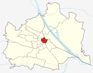
Neubau (Neubau)
.svg)
- 7. district of Vienna
 Hiking in Neubau
Neubau, a vibrant district in Vienna, Austria, is not traditionally known for its hiking trails like the surrounding nature areas. However, it offers access to some scenic routes and nearby parks that can provide a pleasant experience for those looking to enjoy a nature walk or light hiking within the urban environment.
Nearby Hiking Areas and Options:
-
Wienerwald (Vienna Woods):
- Just a short trip from Neubau, the Wienerwald offers a plethora of hiking trails through beautiful forests, hills, and meadows. Popular starting points are easily accessible via public transport.
-
Lainzer Tiergarten:
- Located in the outskirts of Vienna, this wildlife preserve features various hiking trails, historic sites, and beautiful viewpoints. It's great for a half-day trip and offers well-marked paths suitable for all skill levels.
-
Kahlenberg:
- Accessible by tram and bus from Neubau, this famous hill provides stunning vistas of the Danube and the city of Vienna. The hiking routes vary in difficulty and length, making it a popular spot for both locals and tourists.
-
Setagaya Park:
- While more of a walking area than a hiking trail, this park in Neubau offers a peaceful atmosphere and beautifully landscaped gardens, perfect for a leisurely stroll.
Tips for Hiking in Neubau:
- Public Transport: Utilize Vienna’s efficient U-Bahn and tram systems to reach nearby hiking areas easily.
- Gear: While Neubau itself is urban, it’s a good idea to wear comfortable hiking shoes and pack water, snacks, and weather-appropriate clothing when venturing into the nearby Wienerwald or Lainzer Tiergarten.
- Trail Maps: Review trail maps beforehand for accessibility and to ensure you choose the right path for your experience level.
Conclusion:
While Neubau may not have extensive hiking trails within its boundaries, it offers quick access to some beautiful nature areas in and around Vienna. Enjoying a hike in the Wienerwald or Lainzer Tiergarten is a fantastic way to experience the natural beauty surrounding the city, all while being able to easily return to the urban vibe of Neubau.
- Country:

- Postal Code: 1070
- Licence Plate Code: W
- Coordinates: 48° 12' 9" N, 16° 20' 53" E


- GPS tracks (wikiloc): [Link]
- AboveSeaLevel: 214 м m
- Area: 1.61 sq km
- Web site: http://www.wien.gv.at/bezirke/neubau/
- Wikipedia en: wiki(en)
- Wikipedia: wiki(de)
- Wikidata storage: Wikidata: Q664835
- Wikipedia Commons Gallery: [Link]
- Wikipedia Commons Category: [Link]
- Freebase ID: [/m/034bwx]
- GeoNames ID: Alt: [2770853]
- VIAF ID: Alt: [148041844]
- GND ID: Alt: [4079296-1]
- archINFORM location ID: [3687]
- Library of Congress authority ID: Alt: [no94037559]
- MusicBrainz area ID: [9cfef528-fd3f-432e-920d-6d896343587f]
- Austrian municipality key: [90701]
Shares border with regions:
Josefstadt
- 8. district of Vienna
Hiking in Josefstadt
Josefstadt is a district in Vienna, Austria, known more for its urban characteristics rather than hiking trails. However, its proximity to the Vienna Woods (Wienerwald) offers great opportunities for hiking enthusiasts. While the district itself may not have dedicated hiking trails, you can easily access various trails in the nearby areas....
- Country:
- Postal Code: 1080
- Licence Plate Code: W
- Coordinates: 48° 12' 39" N, 16° 20' 53" E
- GPS tracks (wikiloc): [Link]
- AboveSeaLevel: 209 м m
- Area: 1.08 sq km
- Web site: [Link]
Ottakring
- 16. district of Vienna
Hiking in Ottakring
Ottakring is a vibrant district in Vienna, Austria, known for its mix of urban culture and access to nature. While Ottakring is primarily an urban area, it serves as a gateway to various hiking opportunities in the surrounding regions. Here are some highlights and tips for hiking near Ottakring:...
- Country:
- Postal Code: 1160
- Licence Plate Code: W
- Coordinates: 48° 12' 45" N, 16° 18' 38" E
- GPS tracks (wikiloc): [Link]
- AboveSeaLevel: 247 м m
- Area: 8.65 sq km
- Web site: [Link]

Innere Stadt
- first district of Vienna
Hiking in Innere Stadt
Innere Stadt, the historic city center of Vienna, Austria, is not typically known for hiking in the traditional sense; however, it offers plenty of opportunities for urban exploration and walking that can be quite enjoyable and fulfilling. The area is rich in history, culture, and stunning architecture, making it an ideal destination for long strolls and leisurely walks....
- Country:
- Postal Code: 1010
- Licence Plate Code: W
- Coordinates: 48° 12' 35" N, 16° 22' 12" E
- GPS tracks (wikiloc): [Link]
- AboveSeaLevel: 192 м m
- Area: 3.01 sq km
- Web site: [Link]
Rudolfsheim-Fünfhaus
- 15. district of Vienna
Hiking in Rudolfsheim-Fünfhaus
Rudolfsheim-Fünfhaus is a district in Vienna, Austria, primarily known for its urban atmosphere rather than extensive hiking trails. However, outdoor enthusiasts can still enjoy various activities in and around the district. Here are some suggestions:...
- Country:
- Postal Code: 1150
- Licence Plate Code: W
- Coordinates: 48° 12' 3" N, 16° 19' 12" E
- GPS tracks (wikiloc): [Link]
- AboveSeaLevel: 221 м m
- Area: 3.86 sq km
- Web site: [Link]
Mariahilf
- 6. district of Vienna
Hiking in Mariahilf
Mariahilf, a vibrant district in Vienna, Austria, is better known for its urban landscape, cultural offerings, and shopping rather than hiking. However, if you’re looking for hiking opportunities near Mariahilf, you can explore nearby natural areas and trails within the larger Vienna region....
- Country:
- Postal Code: 1060
- Licence Plate Code: W
- Coordinates: 48° 11' 43" N, 16° 20' 59" E
- GPS tracks (wikiloc): [Link]
- AboveSeaLevel: 198 м m
- Area: 1.48 sq km
- Web site: [Link]