Neuillé (Neuillé)

- commune in Maine-et-Loire, France
- Country:

- Postal Code: 49680
- Coordinates: 47° 20' 28" N, 0° 2' 6" E


- GPS tracks (wikiloc): [Link]
- Area: 13.56 sq km
- Population: 995
- Web site: http://neuille.fr
- Wikipedia en: wiki(en)
- Wikipedia: wiki(fr)
- Wikidata storage: Wikidata: Q1384861
- Wikipedia Commons Category: [Link]
- Freebase ID: [/m/03x_sz4]
- GeoNames ID: Alt: [6435255]
- SIREN number: [214902249]
- Twitter username: Alt: [Neuille_49]
- INSEE municipality code: 49224
Shares border with regions:

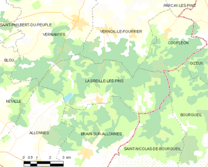
La Breille-les-Pins
- commune in Maine-et-Loire, France
- Country:
- Postal Code: 49390
- Coordinates: 47° 20' 26" N, 0° 4' 40" E
- GPS tracks (wikiloc): [Link]
- Area: 27.57 sq km
- Population: 595
- Web site: [Link]


Allonnes
- commune in Maine-et-Loire, France
- Country:
- Postal Code: 49650
- Coordinates: 47° 17' 35" N, 0° 1' 24" E
- GPS tracks (wikiloc): [Link]
- AboveSeaLevel: 27 м m
- Area: 36.33 sq km
- Population: 3037
- Web site: [Link]


Blou
- commune in Maine-et-Loire, France
- Country:
- Postal Code: 49160
- Coordinates: 47° 21' 44" N, 0° 2' 14" E
- GPS tracks (wikiloc): [Link]
- Area: 21.46 sq km
- Population: 1007


Vivy
- commune in Maine-et-Loire, France
- Country:
- Postal Code: 49680
- Coordinates: 47° 19' 35" N, 0° 3' 16" E
- GPS tracks (wikiloc): [Link]
- Area: 23.17 sq km
- Population: 2574

Vernantes
- commune in Maine-et-Loire, France
- Country:
- Postal Code: 49390
- Coordinates: 47° 23' 35" N, 0° 3' 7" E
- GPS tracks (wikiloc): [Link]
- Area: 40.77 sq km
- Population: 1988