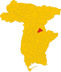
Nimis (Nimis)
- Italian comune
Nimis is an intriguing area located in the Hälsingland region of Sweden, known for its striking natural beauty and unique landscapes. The area is primarily known for the Nimis structure, an art installation made from driftwood, which attracts visitors and hikers alike. While Nimis is not a traditional hiking destination, it provides opportunities for outdoor enthusiasts to explore the surrounding areas.
Hiking in Nimis:
-
Scenic Trails: The area around Nimis offers a variety of scenic trails that take you through forests, along the coastline, and near the Baltic Sea. The diverse landscapes provide a wonderful backdrop for hiking.
-
Nature Experience: Hiking here allows you to experience the rich flora and fauna of the region. You might spot various wildlife, including birds and small mammals, as well as various plant species.
-
Access and Directions: To reach Nimis, you may need to start from a nearby town or village. It's advisable to have a map or a GPS device to navigate the less-marked paths, as trails can vary in difficulty and conditions.
-
Be Prepared: Ensure you wear proper hiking footwear, carry sufficient water, snacks, and a first-aid kit. Depending on the season, weather conditions can change rapidly, so layers and waterproof gear are recommended.
-
Respect the Environment: As with any hiking experience, be mindful of the environment by sticking to marked trails, not disturbing wildlife, and following Leave No Trace principles.
-
Cultural Significance: While hiking, take time to appreciate the cultural significance of the area and the art installation itself, as it reflects the relationship between human creativity and nature.
Remember that the Nimis area is rugged and remote, so always prioritize safety when hiking in less-traveled areas. Enjoy your hike and the stunning natural beauty of Nimis!
- Country:

- Postal Code: 33045
- Local Dialing Code: 0432
- Licence Plate Code: UD
- Coordinates: 46° 12' 0" N, 13° 16' 0" E


- GPS tracks (wikiloc): [Link]
- AboveSeaLevel: 207 м m
- Area: 33.9 sq km
- Population: 2711
- Web site: http://www.comune.nimis.ud.it
- Wikipedia en: wiki(en)
- Wikipedia: wiki(it)
- Wikidata storage: Wikidata: Q53296
- Wikipedia Commons Category: [Link]
- Freebase ID: [/m/0gh7j9]
- GeoNames ID: Alt: [6540404]
- VIAF ID: Alt: [236547069]
- OSM relation ID: [79195]
- WOEID: [719334]
- Quora topic ID: [Nimis]
- UN/LOCODE: [ITMNI]
- Digital Atlas of the Roman Empire ID: [16543]
- ISTAT ID: 030065
- Italian cadastre code: F898
Shares border with regions:


Attimis
- Italian comune
Attimis is a charming village located in the Friuli Venezia Giulia region of northeastern Italy. It is known for its beautiful natural landscapes, lush hills, and vineyards, which provide a stunning backdrop for hiking enthusiasts. Here are some points to consider if you are planning a hiking trip in and around Attimis:...
- Country:

- Postal Code: 33040
- Local Dialing Code: 0432
- Licence Plate Code: UD
- Coordinates: 46° 11' 0" N, 13° 18' 0" E


- GPS tracks (wikiloc): [Link]
- AboveSeaLevel: 133 м m
- Area: 33.24 sq km
- Population: 1744
- Web site: [Link]
Lusevera
- Italian comune
Lusevera is a picturesque village located in the Friuli-Venezia Giulia region of northeastern Italy. Known for its stunning natural landscapes, Lusevera offers a fantastic hiking experience for outdoor enthusiasts....
- Country:

- Postal Code: 33010
- Local Dialing Code: 0432
- Licence Plate Code: UD
- Coordinates: 46° 16' 0" N, 13° 16' 0" E


- GPS tracks (wikiloc): [Link]
- AboveSeaLevel: 325 м m
- Area: 53.05 sq km
- Population: 625
- Web site: [Link]


Povoletto
- Italian comune
Povoletto is a picturesque municipality located in the Friuli Venezia Giulia region of northeastern Italy. The area offers a variety of hiking opportunities, showcasing its beautiful landscapes, rich natural diversity, and cultural heritage. Here are some highlights for hiking in Povoletto:...
- Country:

- Postal Code: 33040
- Local Dialing Code: 0432
- Licence Plate Code: UD
- Coordinates: 46° 7' 0" N, 13° 17' 0" E


- GPS tracks (wikiloc): [Link]
- AboveSeaLevel: 116 м m
- Area: 38.41 sq km
- Population: 5425
- Web site: [Link]


Reana del Rojale
- Italian comune
Reana del Rojale is a charming village located in the Friuli Venezia Giulia region of northern Italy. It offers a beautiful natural landscape and is an excellent destination for hiking enthusiasts. Here are some key points about hiking in Reana del Rojale:...
- Country:

- Postal Code: 33010
- Local Dialing Code: 0432
- Licence Plate Code: UD
- Coordinates: 46° 9' 0" N, 13° 14' 0" E


- GPS tracks (wikiloc): [Link]
- AboveSeaLevel: 168 м m
- Area: 20.33 sq km
- Population: 4905
- Web site: [Link]


Taipana
- Italian comune
Taipana is a lesser-known gem in Italy, located in the region of Friuli Venezia Giulia. While it may not be a prominent hiking destination compared to more famous areas, it offers beautiful landscapes and a tranquil environment for hiking enthusiasts looking to explore more off-the-beaten-path locations....
- Country:

- Postal Code: 33040
- Local Dialing Code: 0432
- Licence Plate Code: UD
- Coordinates: 46° 15' 0" N, 13° 20' 0" E


- GPS tracks (wikiloc): [Link]
- AboveSeaLevel: 478 м m
- Area: 65.44 sq km
- Population: 596
- Web site: [Link]


Tarcento
- Italian comune
Tarcento, located in the Friuli Venezia Giulia region of Italy, offers beautiful hiking opportunities for outdoor enthusiasts. Nestled in a picturesque valley surrounded by the stunning Julian Alps and the nearby rivers, Tarcento is a great base for exploring the natural features of the area....
- Country:

- Postal Code: 33017
- Local Dialing Code: 0432
- Licence Plate Code: UD
- Coordinates: 46° 13' 0" N, 13° 13' 0" E


- GPS tracks (wikiloc): [Link]
- AboveSeaLevel: 230 м m
- Area: 35.42 sq km
- Population: 8964
- Web site: [Link]

