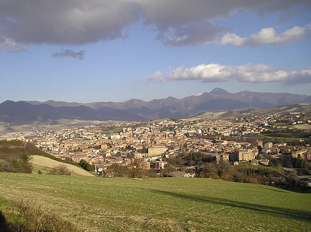
Nocera Umbra (Nocera Umbra)
.svg)
- Italian comune
 Hiking in Nocera Umbra
Nocera Umbra is a charming town in the Umbria region of Italy, known for its beautiful landscapes and rich history. It is surrounded by the stunning hills of the Apennines, making it a fantastic destination for hiking enthusiasts. Here are some key points to consider if you're planning a hiking trip to Nocera Umbra:
Trails and Routes
-
Natural Park of Monte Cucco: This nearby park offers numerous trails for all skill levels, featuring breathtaking views, limestone formations, and diverse flora and fauna. Trails often lead to panoramic viewpoints, and you might even encounter caves to explore.
-
Sentiero della Salute (Health Trail): A scenic route that is well-marked and suitable for various skill levels, providing a mix of natural scenery and wellness experiences, including stops at historic sites.
-
Via di Francesco: Part of a longer pilgrimage route that follows the footsteps of Saint Francis of Assisi, it offers a spiritually enriching hiking experience through the serene countryside and quaint villages.
-
Local Trails: There are many less-traveled paths that meander through forests and agricultural land, allowing for a more secluded and personal connection with nature.
What to Prepare
- Footwear: Sturdy hiking boots are recommended due to the varied terrain.
- Clothing: Dress in layers to accommodate changing weather conditions, and wear moisture-wicking fabrics.
- Navigation Tools: Maps or GPS devices are helpful since signage may vary.
- Water and Snacks: Carry enough water and energy-boosting snacks for your hikes.
Seasonal Considerations
- Spring and Fall: Ideal for hiking, with mild temperatures and beautiful blooming flora or autumn colors.
- Summer: Can be hot; start early to avoid the midday sun.
- Winter: Snow can make trails challenging; check conditions and be prepared for cold weather.
Local Attractions
Nocera Umbra is not only about hiking; the town itself has historical sites, thermal springs, and local cuisine to explore. Be sure to take some time to enjoy the culture and beautiful architecture!
Safety Tips
- Always inform someone of your hiking plans.
- Hike with a companion if possible.
- Pay attention to trail markers and maps.
- Be cautious of wildlife and adhere to local wildlife guidelines.
Hiking in and around Nocera Umbra offers a wonderful mix of outdoor adventure and cultural discovery, making it a perfect spot for both seasoned hikers and those looking to enjoy nature!
- Country:

- Postal Code: 06025
- Local Dialing Code: 0742
- Licence Plate Code: PG
- Coordinates: 43° 7' 0" N, 12° 47' 0" E


- GPS tracks (wikiloc): [Link]
- AboveSeaLevel: 520 м m
- Area: 157.17 sq km
- Population: 5711
- Web site: http://www.comune.noceraumbra.pg.it
- Wikipedia en: wiki(en)
- Wikipedia: wiki(it)
- Wikidata storage: Wikidata: Q20491
- Wikipedia Commons Category: [Link]
- Freebase ID: [/m/074_l9]
- GeoNames ID: Alt: [6542042]
- BnF ID: [11963994g]
- VIAF ID: Alt: [155927860]
- OSM relation ID: [42309]
- GND ID: Alt: [4392894-8]
- WOEID: [719354]
- UN/LOCODE: [ITNBA]
- Digital Atlas of the Roman Empire ID: [17233]
- ISTAT ID: 054034
- Italian cadastre code: F911
Shares border with regions:
Fabriano
- Italian comune
Hiking in Fabriano
Fabriano is a charming town located in the Marche region of Italy, nestled in the Apennine Mountains. The area is rich in natural beauty, making it an excellent destination for hiking enthusiasts. Here are some highlights of hiking in and around Fabriano:...
- Country:
- Postal Code: 60044
- Local Dialing Code: 0732
- Licence Plate Code: AN
- Coordinates: 43° 20' 19" N, 12° 54' 31" E
- GPS tracks (wikiloc): [Link]
- AboveSeaLevel: 325 м m
- Area: 272.08 sq km
- Population: 30809
- Web site: [Link]


Assisi
- city in Italy
Hiking in Assisi
Hiking in Assisi, a picturesque town in Umbria, Italy, offers a blend of natural beauty, historical significance, and spiritual experience. The region is adorned with rolling hills, olive groves, and vineyards, making it a fantastic destination for both novice and experienced hikers. Here are some highlights:...
- Country:
- Postal Code: 06081
- Local Dialing Code: 075
- Licence Plate Code: PG
- Coordinates: 43° 4' 12" N, 12° 37' 3" E
- GPS tracks (wikiloc): [Link]
- AboveSeaLevel: 424 м m
- Area: 187.19 sq km
- Population: 28290
- Web site: [Link]

Foligno
- Italian comune
Hiking in Foligno
Foligno, located in the heart of Italy's Umbria region, offers a beautiful landscape perfect for hiking enthusiasts. The area is characterized by rolling hills, picturesque valleys, and a rich tapestry of nature that includes forests, fields, and scenic views....
- Country:
- Postal Code: 06034
- Local Dialing Code: 0742
- Licence Plate Code: PG
- Coordinates: 42° 57' 22" N, 12° 42' 12" E
- GPS tracks (wikiloc): [Link]
- AboveSeaLevel: 234 м m
- Area: 264.67 sq km
- Population: 57059
- Web site: [Link]


Gualdo Tadino
- Italian comune
Hiking in Gualdo Tadino
Gualdo Tadino, located in the Umbria region of Italy, offers a fantastic selection of hiking trails that showcase the area's natural beauty, rich history, and stunning landscapes. Here are some highlights about hiking in and around Gualdo Tadino:...
- Country:
- Postal Code: 06023
- Local Dialing Code: 075
- Licence Plate Code: PG
- Coordinates: 43° 14' 0" N, 12° 47' 0" E
- GPS tracks (wikiloc): [Link]
- AboveSeaLevel: 536 м m
- Area: 124.29 sq km
- Population: 15018
- Web site: [Link]


Valfabbrica
- Italian comune
Hiking in Valfabbrica
Valfabbrica is a charming town located in the Umbria region of Italy, surrounded by beautiful landscapes, rolling hills, and lush greenery. It's an excellent destination for hiking enthusiasts looking for a mix of nature, history, and culture....
- Country:
- Postal Code: 06029
- Local Dialing Code: 075
- Licence Plate Code: PG
- Coordinates: 43° 10' 0" N, 12° 36' 0" E
- GPS tracks (wikiloc): [Link]
- AboveSeaLevel: 289 м m
- Area: 92.3 sq km
- Population: 3402
- Web site: [Link]


Valtopina
- Italian comune
Hiking in Valtopina
Valtopina is a picturesque area located in the region of Umbria, Italy. Nestled in a valley surrounded by lush hills, it offers a variety of hiking opportunities for both beginners and experienced hikers. Here are some highlights to consider if you’re planning to hike in Valtopina:...
- Country:
- Postal Code: 06030
- Local Dialing Code: 0742
- Licence Plate Code: PG
- Coordinates: 43° 4' 0" N, 12° 45' 0" E
- GPS tracks (wikiloc): [Link]
- AboveSeaLevel: 366 м m
- Area: 40.57 sq km
- Population: 1380
- Web site: [Link]
Fiuminata
- Italian comune
Hiking in Fiuminata
Fiuminata, located in the Marche region of Italy, offers a stunning backdrop for hiking enthusiasts. Nestled in the Apennine Mountains, it is surrounded by diverse landscapes, including lush forests, rocky ridges, and beautiful valleys. Here are some key points to consider when hiking in and around Fiuminata:...
- Country:
- Postal Code: 62025
- Local Dialing Code: 0737
- Licence Plate Code: MC
- Coordinates: 43° 11' 19" N, 12° 55' 54" E
- GPS tracks (wikiloc): [Link]
- AboveSeaLevel: 479 м m
- Area: 76.22 sq km
- Population: 1332
- Web site: [Link]
Serravalle di Chienti
- Italian comune
Hiking in Serravalle di Chienti
Serravalle di Chienti is a picturesque town located in the Marche region of Italy, surrounded by stunning landscapes that are perfect for hiking enthusiasts. The area is known for its diverse terrain, featuring hills, valleys, and forests, making it an ideal destination for both beginner and experienced hikers....
- Country:
- Postal Code: 62038
- Local Dialing Code: 0737
- Licence Plate Code: MC
- Coordinates: 43° 4' 20" N, 12° 57' 7" E
- GPS tracks (wikiloc): [Link]
- AboveSeaLevel: 667 м m
- Area: 95.99 sq km
- Population: 1056
- Web site: [Link]