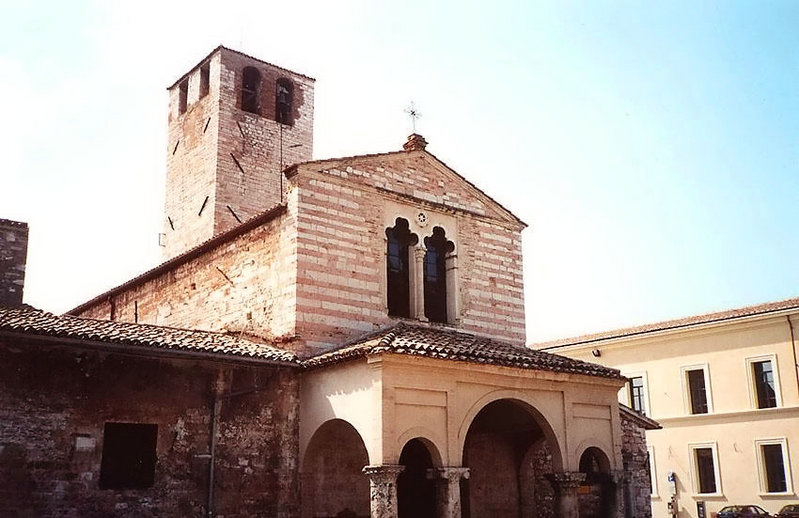
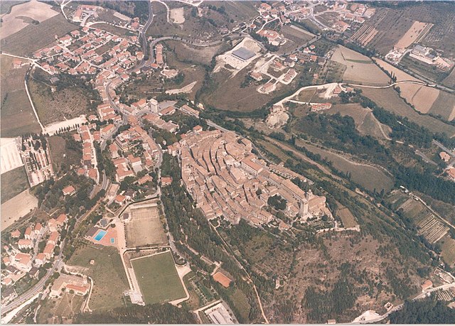
Serravalle di Chienti (Serravalle di Chienti)
.svg)
- Italian comune
 Hiking in Serravalle di Chienti
Serravalle di Chienti is a picturesque town located in the Marche region of Italy, surrounded by stunning landscapes that are perfect for hiking enthusiasts. The area is known for its diverse terrain, featuring hills, valleys, and forests, making it an ideal destination for both beginner and experienced hikers.
Trails and Routes
-
Sentiero della Valle del Chienti: This trail follows the Chienti River and offers beautiful views of the surrounding landscape. It's suitable for various levels and is a great way to experience the natural beauty of the area.
-
Monte San Vicino: To the east of Serravalle di Chienti, Monte San Vicino offers more challenging trails. The ascent provides breathtaking panoramic views and is a popular spot for those looking for a rewarding hiking experience.
-
Foresta di Civitella: This area features numerous trails weaving through dense woods, providing a serene environment for hikers. The forest is home to diverse flora and fauna, making it perfect for nature lovers.
Seasonal Considerations
-
Spring and Fall: These seasons are typically the best for hiking, with mild temperatures and beautiful scenery. Wildflowers bloom in spring, and autumn foliage enhances the trails' natural beauty.
-
Summer: While summer can be warm, early morning or late afternoon hikes are ideal for avoiding the heat.
-
Winter: Trails may be less accessible due to snow, but winter hiking can offer a unique experience if you are prepared for colder weather and understand the risks involved.
Safety Tips
- Appropriate Gear: Always wear good hiking boots, and carry plenty of water, snacks, a map or GPS device, and other essential gear.
- Weather Awareness: Check the weather forecast before heading out, as conditions can change quickly in mountainous areas.
- Trail Etiquette: Stay on marked paths to preserve the natural environment and be courteous to other hikers and wildlife.
Local Culture
In addition to hiking, you can immerse yourself in the local culture by exploring nearby villages, tasting regional cuisine, and visiting historical sites. The Marche region is known for its delicious food, so don’t miss the opportunity to enjoy local specialties after a day of hiking.
Conclusion
Serravalle di Chienti offers a fantastic blend of outdoor adventure and cultural experiences. Whether you prefer leisurely walks along the river or more challenging hikes up the mountains, you'll find plenty of options to enjoy the natural beauty of this region. Make sure to plan your hike according to your experience level and enjoy the adventure!
- Country:

- Postal Code: 62038
- Local Dialing Code: 0737
- Licence Plate Code: MC
- Coordinates: 43° 4' 20" N, 12° 57' 7" E


- GPS tracks (wikiloc): [Link]
- AboveSeaLevel: 667 м m
- Area: 95.99 sq km
- Population: 1056
- Web site: http://www.serravalle.sinp.net/
- Wikipedia en: wiki(en)
- Wikipedia: wiki(it)
- Wikidata storage: Wikidata: Q94976
- Wikipedia Commons Category: [Link]
- Freebase ID: [/m/0gl7c7]
- GeoNames ID: Alt: [6536794]
- VIAF ID: Alt: [125284552]
- OSM relation ID: [42249]
- TGN ID: [5002654]
- ISTAT ID: 043052
- Italian cadastre code: I661
Shares border with regions:

Foligno
- Italian comune
Hiking in Foligno
Foligno, located in the heart of Italy's Umbria region, offers a beautiful landscape perfect for hiking enthusiasts. The area is characterized by rolling hills, picturesque valleys, and a rich tapestry of nature that includes forests, fields, and scenic views....
- Country:
- Postal Code: 06034
- Local Dialing Code: 0742
- Licence Plate Code: PG
- Coordinates: 42° 57' 22" N, 12° 42' 12" E
- GPS tracks (wikiloc): [Link]
- AboveSeaLevel: 234 м m
- Area: 264.67 sq km
- Population: 57059
- Web site: [Link]

Nocera Umbra
- Italian comune
Hiking in Nocera Umbra
Nocera Umbra is a charming town in the Umbria region of Italy, known for its beautiful landscapes and rich history. It is surrounded by the stunning hills of the Apennines, making it a fantastic destination for hiking enthusiasts. Here are some key points to consider if you're planning a hiking trip to Nocera Umbra:...
- Country:
- Postal Code: 06025
- Local Dialing Code: 0742
- Licence Plate Code: PG
- Coordinates: 43° 7' 0" N, 12° 47' 0" E
- GPS tracks (wikiloc): [Link]
- AboveSeaLevel: 520 м m
- Area: 157.17 sq km
- Population: 5711
- Web site: [Link]


Camerino
- Italian comune
Hiking in Camerino
Camerino is a charming town located in the Marche region of Italy, surrounded by beautiful landscapes, hills, and mountains that offer excellent hiking opportunities. Here are some highlights for hiking in and around Camerino:...
- Country:
- Postal Code: 62032
- Local Dialing Code: 0737
- Licence Plate Code: MC
- Coordinates: 43° 8' 0" N, 13° 4' 0" E
- GPS tracks (wikiloc): [Link]
- AboveSeaLevel: 670 м m
- Area: 129.88 sq km
- Population: 6956
- Web site: [Link]
Fiuminata
- Italian comune
Hiking in Fiuminata
Fiuminata, located in the Marche region of Italy, offers a stunning backdrop for hiking enthusiasts. Nestled in the Apennine Mountains, it is surrounded by diverse landscapes, including lush forests, rocky ridges, and beautiful valleys. Here are some key points to consider when hiking in and around Fiuminata:...
- Country:
- Postal Code: 62025
- Local Dialing Code: 0737
- Licence Plate Code: MC
- Coordinates: 43° 11' 19" N, 12° 55' 54" E
- GPS tracks (wikiloc): [Link]
- AboveSeaLevel: 479 м m
- Area: 76.22 sq km
- Population: 1332
- Web site: [Link]
Monte Cavallo
- Italian comune
Hiking in Monte Cavallo
Monte Cavallo, or "Hochfügen" as it’s sometimes referred to, is a stunning mountain in the Tyrolean Alps, located in northern Italy near the border with Austria. The area is renowned for its breathtaking views, diverse hiking trails, and vibrant alpine flora....
- Country:
- Postal Code: 62030
- Local Dialing Code: 0737
- Licence Plate Code: MC
- Coordinates: 43° 0' 25" N, 13° 0' 19" E
- GPS tracks (wikiloc): [Link]
- AboveSeaLevel: 648 м m
- Area: 38.51 sq km
- Population: 129
- Web site: [Link]


Muccia
- Italian comune
Hiking in Muccia
Muccia is a small town located in the Marche region of Italy, known for its picturesque landscapes and proximity to the Sibillini Mountains. Hiking in and around Muccia offers a unique experience, as the area boasts a variety of trails that cater to different skill levels and interests....
- Country:
- Postal Code: 62034
- Local Dialing Code: 0737
- Licence Plate Code: MC
- Coordinates: 43° 4' 55" N, 13° 2' 39" E
- GPS tracks (wikiloc): [Link]
- AboveSeaLevel: 454 м m
- Area: 25.91 sq km
- Population: 899
- Web site: [Link]
Pieve Torina
- Italian comune
Hiking in Pieve Torina
Pieve Torina is a beautiful village located in the Marche region of Italy, known for its picturesque landscapes and charming medieval architecture. The area offers various hiking opportunities that allow enthusiasts to explore the stunning Apennine Mountains and the surrounding countryside....
- Country:
- Postal Code: 62036
- Local Dialing Code: 0737
- Licence Plate Code: MC
- Coordinates: 43° 2' 40" N, 13° 3' 1" E
- GPS tracks (wikiloc): [Link]
- AboveSeaLevel: 470 м m
- Area: 74.8 sq km
- Population: 1389
- Web site: [Link]
Sefro
- Italian comune
Hiking in Sefro
Sefro, a charming village in the province of Macerata in Italy’s Marche region, offers a unique hiking experience amidst picturesque landscapes. The area is characterized by rolling hills, lush forests, and beautiful valleys, making it an excellent choice for outdoor enthusiasts....
- Country:
- Postal Code: 62030
- Local Dialing Code: 0737
- Licence Plate Code: MC
- Coordinates: 43° 8' 47" N, 12° 56' 57" E
- GPS tracks (wikiloc): [Link]
- AboveSeaLevel: 502 м m
- Area: 42.54 sq km
- Population: 407
- Web site: [Link]


Visso
- Italian comune
Hiking in Visso
Visso, a charming town located in the Marche region of Italy, is a wonderful destination for hiking enthusiasts. Nestled in the Sibillini Mountains National Park, Visso offers stunning landscapes, diverse wildlife, and a variety of well-marked trails that cater to different skill levels....
- Country:
- Postal Code: 62039
- Local Dialing Code: 0737
- Licence Plate Code: MC
- Coordinates: 42° 55' 51" N, 13° 5' 18" E
- GPS tracks (wikiloc): [Link]
- AboveSeaLevel: 607 м m
- Area: 100.4 sq km
- Population: 1076
- Web site: [Link]