Noroy-le-Bourg (Noroy-le-Bourg)

- commune in Haute-Saône, France
- Country:

- Postal Code: 70000
- Coordinates: 47° 36' 53" N, 6° 18' 20" E


- GPS tracks (wikiloc): [Link]
- Area: 31.78 sq km
- Population: 484
- Web site: http://www.noroy-le-bourg.fr/
- Wikipedia en: wiki(en)
- Wikipedia: wiki(fr)
- Wikidata storage: Wikidata: Q901542
- Wikipedia Commons Category: [Link]
- Freebase ID: [/m/03ntgvy]
- GeoNames ID: Alt: [6442045]
- SIREN number: [217003904]
- BnF ID: [152727827]
- VIAF ID: Alt: [298455631]
- INSEE municipality code: 70390
Shares border with regions:

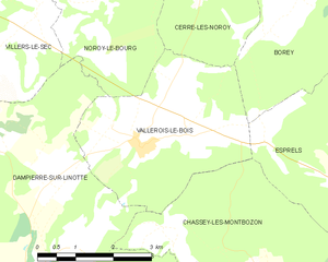
Vallerois-le-Bois
- commune in Haute-Saône, France
- Country:
- Postal Code: 70000
- Coordinates: 47° 32' 55" N, 6° 17' 21" E
- GPS tracks (wikiloc): [Link]
- Area: 12.59 sq km
- Population: 257


Villers-le-Sec, Haute-Saône
- commune in Haute-Saône, France
- Country:
- Postal Code: 70000
- Coordinates: 47° 35' 57" N, 6° 13' 11" E
- GPS tracks (wikiloc): [Link]
- Area: 11.11 sq km
- Population: 527
- Web site: [Link]


Colombe-lès-Vesoul
- commune in Haute-Saône, France
- Country:
- Postal Code: 70000
- Coordinates: 47° 36' 49" N, 6° 12' 45" E
- GPS tracks (wikiloc): [Link]
- AboveSeaLevel: 287 м m
- Area: 7.94 sq km
- Population: 468


Calmoutier
- commune in Haute-Saône, France
- Country:
- Postal Code: 70240
- Coordinates: 47° 38' 44" N, 6° 16' 51" E
- GPS tracks (wikiloc): [Link]
- Area: 14.04 sq km
- Population: 259

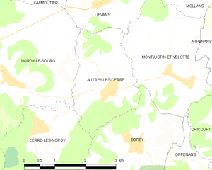
Autrey-lès-Cerre
- commune in Haute-Saône, France
- Country:
- Postal Code: 70110
- Coordinates: 47° 36' 32" N, 6° 20' 53" E
- GPS tracks (wikiloc): [Link]
- Area: 5.48 sq km
- Population: 232

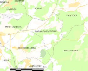
Dampvalley-lès-Colombe
- commune in Haute-Saône, France
- Country:
- Postal Code: 70000
- Coordinates: 47° 37' 42" N, 6° 14' 44" E
- GPS tracks (wikiloc): [Link]
- Area: 6.26 sq km
- Population: 107

Dampierre-sur-Linotte
- commune in Haute-Saône, France
- Country:
- Postal Code: 70230
- Coordinates: 47° 30' 42" N, 6° 13' 56" E
- GPS tracks (wikiloc): [Link]
- Area: 32.48 sq km
- Population: 804


Liévans
- commune in Haute-Saône, France
- Country:
- Postal Code: 70240
- Coordinates: 47° 38' 15" N, 6° 20' 51" E
- GPS tracks (wikiloc): [Link]
- Area: 4.16 sq km
- Population: 139


Cerre-lès-Noroy
- commune in Haute-Saône, France
- Country:
- Postal Code: 70000
- Coordinates: 47° 36' 3" N, 6° 18' 58" E
- GPS tracks (wikiloc): [Link]
- Area: 9.96 sq km
- Population: 229