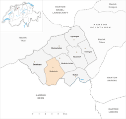
Oberbuchsiten (Oberbuchsiten)
- municipality in Switzerland
Oberbuchsiten is a charming municipality located in the canton of Solothurn, Switzerland. It's a great area for hiking, surrounded by beautiful landscapes, rolling hills, and scenic views of the Swiss countryside. Here are some key points to consider if you're planning a hiking trip in Oberbuchsiten:
Trails and Routes
- Local Trails: There are several well-marked hiking paths around Oberbuchsiten that cater to various skill levels. These trails often connect to other hiking routes in the surrounding regions.
- Nature Trails: Explore nature trails that focus on the local flora and fauna, providing an educational experience while you enjoy the outdoors.
- Scenic Views: Engage in hikes that offer panoramic views of the Jura Mountains and the Aare River, enhancing your hiking experience with stunning backdrops.
Difficulty Levels
- Easy to Moderate: Many of the hiking trails in the region are suitable for families and beginners, with gentle inclines and well-maintained paths.
- Challenging Hikes: For more experienced hikers, there may be routes that venture into steeper terrain and require better fitness levels.
Best Times to Hike
- Spring and Fall: The weather during these seasons is generally mild, making it ideal for hiking. You can enjoy the blooming wildflowers in spring and stunning autumn foliage in fall.
- Summer: While summer can be warm, early morning or late afternoon hikes can still be enjoyable.
Tips for Hiking in Oberbuchsiten
- Stay Hydrated: Carry sufficient water, especially during warmer months.
- Wear Proper Gear: Good hiking shoes and weather-appropriate clothing are crucial for a pleasant experience.
- Follow Markings: Stick to designated trails and follow local hiking maps for safety.
- Wildlife Awareness: Be mindful of local wildlife and practice Leave No Trace principles to preserve the natural environment.
Nearby Attractions
- Historical Sites: Take time to explore the local cultural heritage, including churches and traditional Swiss architecture.
- Exploring the Region: The proximity to larger towns such as Solothurn gives you opportunities to experience additional urban hiking and sightseeing.
By planning ahead and respecting the natural environment, you can enjoy a rewarding hiking experience in Oberbuchsiten. Always check local resources for trail conditions and safety advisories before heading out. Happy hiking!
- Country:

- Postal Code: 4625
- Local Dialing Code: 062
- Licence Plate Code: SO
- Coordinates: 47° 18' 39" N, 7° 46' 0" E


- GPS tracks (wikiloc): [Link]
- AboveSeaLevel: 471 м m
- Area: 9.37 sq km
- Population: 2238
- Web site: http://www.oberbuchsiten.ch
- Wikipedia en: wiki(en)
- Wikipedia: wiki(de)
- Wikidata storage: Wikidata: Q67008
- Wikipedia Commons Category: [Link]
- Freebase ID: [/m/0g4qgp]
- GeoNames ID: Alt: [2659406]
- VIAF ID: Alt: [247407364]
- OSM relation ID: [1683560]
- HDS ID: [1062]
- Swiss municipality code: [2406]
Shares border with regions:


Egerkingen
- municipality of Switzerland
Egerkingen, located in the Canton of Solothurn in Switzerland, is a great destination for hiking enthusiasts. Nestled amidst picturesque countryside and rolling hills, the area offers a variety of trails that cater to different skill levels....
- Country:

- Postal Code: 4622
- Local Dialing Code: 062
- Licence Plate Code: SO
- Coordinates: 47° 19' 34" N, 7° 47' 47" E


- GPS tracks (wikiloc): [Link]
- AboveSeaLevel: 516 м m
- Area: 6.93 sq km
- Population: 3520
- Web site: [Link]


Kestenholz
- municipality of Switzerland
Kestenholz is a picturesque village located in the Aargau canton of Switzerland, surrounded by stunning natural landscapes that offer excellent opportunities for hiking. Here are some highlights and tips for hiking in and around Kestenholz:...
- Country:

- Postal Code: 4703
- Local Dialing Code: 062
- Licence Plate Code: SO
- Coordinates: 47° 17' 0" N, 7° 45' 15" E


- GPS tracks (wikiloc): [Link]
- AboveSeaLevel: 498 м m
- Area: 8.59 sq km
- Population: 1798
- Web site: [Link]

