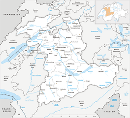
Canton of Solothurn (Kanton Solothurn)
- canton of Switzerland
Hiking in the Canton of Solothurn offers a fantastic blend of natural beauty, historical sites, and picturesque villages. Located in Switzerland, Solothurn is known for its picturesque landscapes, ranging from rolling hills to stunning valleys and the scenic banks of the River Aare.
Key Highlights for Hiking in Solothurn:
-
Diverse Trails: The canton features a variety of trails suitable for different skill levels, from easy walks suitable for families to more challenging hikes for experienced trekkers. Some popular trails include routes around the Weissenstein, which provide breathtaking views over the region.
-
The Weissenstein Mountain: This is one of the most popular hiking destinations in Solothurn, offering numerous trails with varying degrees of difficulty. You can reach the summit by hiking or taking a cable car, and the panoramic views from the top are well worth the effort.
-
Historical Sites: As you hike, you might encounter historical sites, including castles, old churches, and charming villages such as Solothurn itself, which has a rich cultural history and beautiful Baroque architecture.
-
Natural Parks and Reserves: The region is home to several nature parks, which provide a haven for wildlife and a chance to explore serene landscapes filled with diverse flora and fauna.
-
Aare River Trails: The trails along the Aare River are particularly scenic and offer opportunities for combined activities like biking or kayaking, as well as hiking. The calm waters and lush banks create a peaceful setting for a leisurely hike.
-
Seasonal Variations: Each season brings its own charm to the hiking experience in Solothurn. Spring and summer offer lush greenery and blooming wildflowers, while autumn brings stunning foliage colors. Winter hiking is also popular, with opportunities for snowshoeing in certain areas.
-
Culinary Delights: After a day of hiking, you can enjoy some delicious Swiss cuisine in the local restaurants, where you’ll find specialties such as fondue, rösti, and various local wines.
Tips for Hiking in Solothurn:
- Maps and Markings: Ensure you have a good hiking map or use GPS for navigation; trails are usually well-marked but it’s good to be prepared.
- Weather Preparedness: The weather can change quickly in the mountains, so bring layers, rain gear, and enough water and snacks for your hike.
- Local Guides: If you're unfamiliar with the area or want to delve deeper into its history, consider joining guided hikes available from local organizations.
- Wildlife Awareness: Be respectful of local wildlife and follow the guidelines to preserve natural habitats.
Hiking in the Canton of Solothurn is sure to be a rewarding venture, offering not only physical activity but also a chance to soak in the rich culture and stunning landscapes of Switzerland. Enjoy your adventure!
- Country:

- Capital: Solothurn
- Licence Plate Code: SO
- Coordinates: 47° 9' 0" N, 7° 38' 0" E


- GPS tracks (wikiloc): [Link]
- AboveSeaLevel: 432 м m
- Area: 790.45 sq km
- Web site: http://www.so.ch/
- Wikipedia en: wiki(en)
- Wikipedia: wiki(de)
- Wikidata storage: Wikidata: Q11929
- Wikipedia Commons Gallery: [Link]
- Wikipedia Commons Category: [Link]
- Freebase ID: [/m/01qtk5]
- GeoNames ID: Alt: [2658563]
- BnF ID: [11987945n]
- VIAF ID: Alt: [151920205]
- GND ID: Alt: [4055459-4]
- archINFORM location ID: [2920]
- Library of Congress authority ID: Alt: [n80162570]
- MusicBrainz area ID: [420454ef-31b7-464a-b812-2b155cbc8ac0]
- Quora topic ID: [Canton-of-Solothurn]
- Encyclopædia Britannica Online ID: [place/Solothurn-canton-Switzerland]
- Gran Enciclopèdia Catalana ID: [0063513]
- HDS ID: [7386]
- ISNI: Alt: [0000 0001 1017 4328]
- NUTS code: [CH023]
- Klexikon article ID: [Solothurn]
- BabelNet ID: [02290581n]
- STW Thesaurus for Economics ID: [16974-4]
- ISO 3166-2 code: CH-SO
- FIPS 10-4 (countries and regions): SZ18
Includes regions:

Dorneck-Thierstein
- district of the canton of Solothurn, Switzerland
Schwarzbubenland, a picturesque region in Switzerland, is known for its diverse landscapes, charming villages, and rich cultural heritage. The area offers a variety of hiking opportunities suitable for different skill levels, from leisurely walks to challenging treks....
- Country:

- Coordinates: 47° 25' 16" N, 7° 36' 32" E


- GPS tracks (wikiloc): [Link]
- AboveSeaLevel: 646 м m

Olten-Gösgen
- district of the canton of Solothurn, Switzerland
Hiking in the Olten-Gösgen region, located in the Canton of Solothurn in Switzerland, offers beautiful scenery and a variety of trails suitable for different skill levels. Here are some aspects to consider when planning a hike in this area:...
- Country:

- Coordinates: 47° 22' 1" N, 7° 55' 53" E


- GPS tracks (wikiloc): [Link]
- AboveSeaLevel: 415 м m

Solothurn-Lebern
- district of the canton of Solothurn, Switzerland
Hiking in the Solothurn-Lebern region offers a wonderful blend of natural beauty, cultural landmarks, and diverse trails suitable for various skill levels. Here are some highlights and tips for hiking in this area:...
- Country:

- Coordinates: 47° 13' 28" N, 7° 28' 40" E


- GPS tracks (wikiloc): [Link]
- AboveSeaLevel: 558 м m

Thal-Gäu
- district of the canton of Solothurn, Switzerland
Thal-Gäu, located in the Swiss canton of Solothurn, is a picturesque region known for its beautiful landscapes, rolling hills, and lush forests. It offers a range of hiking opportunities suitable for both beginners and experienced hikers. Here are some highlights of hiking in Thal-Gäu:...
- Country:

- Coordinates: 47° 19' 22" N, 7° 39' 33" E


- GPS tracks (wikiloc): [Link]
- AboveSeaLevel: 730 м m

Bucheggberg-Wasseramt
- district of the canton of Solothurn, Switzerland
 Hiking in Bucheggberg-Wasseramt
Bucheggberg-Wasseramt is a picturesque region located in the canton of Bern, Switzerland. It is characterized by its rolling hills, lush landscapes, and a variety of trails suitable for hikers of all levels. Here’s what you might want to know if you’re considering hiking in this area:...
- Country:

- Coordinates: 47° 10' 40" N, 7° 31' 25" E


- GPS tracks (wikiloc): [Link]
- AboveSeaLevel: 569 м m
Shares border with regions:


canton of Bern
- canton of Switzerland
The Canton of Bern, located in Switzerland, offers some of the most stunning landscapes and diverse trails for hiking enthusiasts. This region boasts a mix of alpine scenery, picturesque villages, and lush valleys, making it an excellent destination for all levels of hikers. Here are some highlights you can expect when hiking in the Canton of Bern:...
- Country:

- Capital: Bern
- Licence Plate Code: BE
- Coordinates: 46° 50' 0" N, 7° 37' 0" E


- GPS tracks (wikiloc): [Link]
- AboveSeaLevel: 542 м m
- Area: 5959 sq km
- Population: 1031126
- Web site: [Link]


Aargau
- canton of Switzerland
The Canton of Aargau, located in Switzerland, offers a variety of hiking opportunities that cater to different skill levels and preferences. Here's an overview of what you can expect when hiking in this beautiful region:...
- Country:

- Capital: Aarau
- Licence Plate Code: AG
- Coordinates: 47° 22' 49" N, 8° 0' 51" E


- GPS tracks (wikiloc): [Link]
- AboveSeaLevel: 382 м m
- Area: 1403.77 sq km
- Population: 568671
- Web site: [Link]


Basel-Landschaft
- canton of Switzerland
Hiking in the Canton of Basel-Landschaft, located in Switzerland, offers an excellent opportunity to explore the region's beautiful landscapes, charming villages, and diverse ecosystems. Here are some key points to consider when planning your hike in this area:...
- Country:

- Capital: Liestal
- Licence Plate Code: BL
- Coordinates: 47° 27' 47" N, 7° 45' 21" E


- GPS tracks (wikiloc): [Link]
- AboveSeaLevel: 327 м m
- Area: 517.67 sq km
- Web site: [Link]


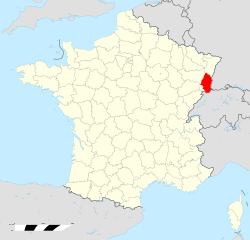
Haut-Rhin
- French department
Haut-Rhin, located in the Alsace region of France, offers some stunning hiking opportunities. The region is characterized by its picturesque landscapes, charming villages, and a rich cultural heritage, making it an excellent destination for hikers of all levels. Here are some highlights and tips for hiking in Haut-Rhin:...
- Country:

- Capital: Colmar
- Coordinates: 47° 57' 51" N, 7° 19' 11" E


- GPS tracks (wikiloc): [Link]
- Area: 3525 sq km
- Population: 762743
- Web site: [Link]


Canton of Jura
- canton of Switzerland
Hiking in the Canton of Jura, Switzerland, is a fantastic experience for outdoor enthusiasts. This region is known for its stunning landscapes, rolling hills, dense forests, and picturesque Jura mountains. Here are some key points to consider if you're planning to hike in the Canton of Jura:...
- Country:

- Capital: Delémont
- Licence Plate Code: JU
- Coordinates: 47° 22' 0" N, 7° 9' 0" E


- GPS tracks (wikiloc): [Link]
- AboveSeaLevel: 435 м m
- Area: 838.51 sq km
- Population: 69100
- Web site: [Link]

