Oberhaslach (Oberhaslach)

- commune in Bas-Rhin, France
- Country:

- Postal Code: 67280
- Coordinates: 48° 33' 2" N, 7° 19' 47" E


- GPS tracks (wikiloc): [Link]
- Area: 25.22 sq km
- Population: 1763
- Wikipedia en: wiki(en)
- Wikipedia: wiki(fr)
- Wikidata storage: Wikidata: Q21591
- Wikipedia Commons Category: [Link]
- Freebase ID: [/m/03m99wj]
- Freebase ID: [/m/03m99wj]
- GeoNames ID: Alt: [6441260]
- GeoNames ID: Alt: [6441260]
- SIREN number: [216703421]
- SIREN number: [216703421]
- BnF ID: [15271484v]
- BnF ID: [15271484v]
- INSEE municipality code: 67342
- INSEE municipality code: 67342
Shares border with regions:

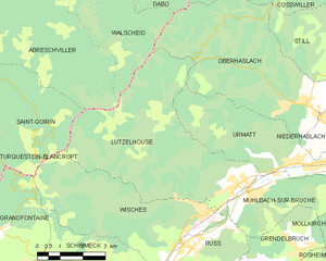
Lutzelhouse
- commune in Bas-Rhin, France
- Country:
- Postal Code: 67130
- Coordinates: 48° 31' 12" N, 7° 17' 18" E
- GPS tracks (wikiloc): [Link]
- Area: 28.58 sq km
- Population: 1886
- Web site: [Link]

Urmatt
- commune in Bas-Rhin, France
- Country:
- Postal Code: 67280
- Coordinates: 48° 31' 37" N, 7° 19' 30" E
- GPS tracks (wikiloc): [Link]
- Area: 13.83 sq km
- Population: 1496
- Web site: [Link]


Dabo
- commune in Moselle, France
- Country:
- Postal Code: 57850
- Coordinates: 48° 39' 14" N, 7° 14' 13" E
- GPS tracks (wikiloc): [Link]
- Area: 48.12 sq km
- Population: 2538

Walscheid
- commune in Moselle, France
- Country:
- Postal Code: 57870
- Coordinates: 48° 39' 14" N, 7° 9' 0" E
- GPS tracks (wikiloc): [Link]
- Area: 38.35 sq km
- Population: 1579
- Web site: [Link]


Wangenbourg-Engenthal
- commune in Bas-Rhin, France
- Country:
- Postal Code: 67710
- Coordinates: 48° 37' 33" N, 7° 18' 15" E
- GPS tracks (wikiloc): [Link]
- AboveSeaLevel: 420 м m
- Area: 31.52 sq km
- Population: 1369


Niederhaslach
- commune in Bas-Rhin, France
- Country:
- Postal Code: 67280
- Coordinates: 48° 32' 34" N, 7° 20' 31" E
- GPS tracks (wikiloc): [Link]
- Area: 6.63 sq km
- Population: 1413


Still
- commune in Bas-Rhin, France
- Country:
- Postal Code: 67190
- Coordinates: 48° 33' 1" N, 7° 24' 12" E
- GPS tracks (wikiloc): [Link]
- Area: 23.2 sq km
- Population: 1800