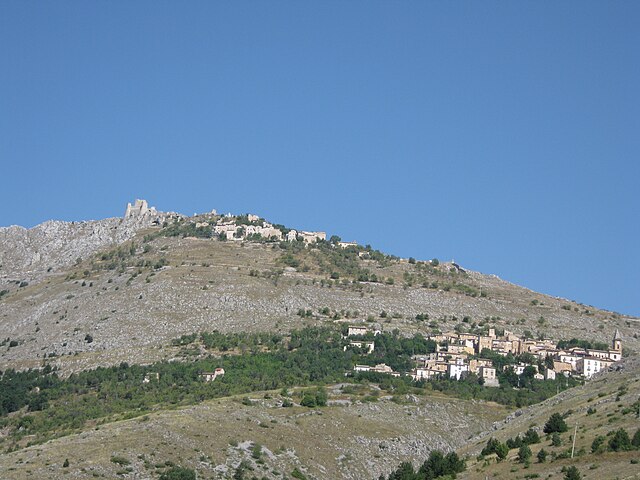
Ofena (Ofena)
.svg)
- Italian comune
 Hiking in Ofena
Ofena is a small village located in the Abruzzo region of Italy, known for its stunning landscapes and proximity to the Gran Sasso e Monti della Laga National Park. Hiking in this area offers a unique combination of picturesque views, diverse flora and fauna, and a rich cultural heritage.
Hiking Trails and Routes
-
Gran Sasso Range: The nearby Gran Sasso, the highest mountain range in the Apennines, provides numerous hiking opportunities. Trails vary from easy walks to challenging ascents. The Campo Imperatore area is a popular starting point for hikes.
-
Cascate delle Marmore: Though a bit of a drive from Ofena, the Marmore Falls is a stunning hike where you can enjoy spectacular waterfalls and breathtaking scenery.
-
Civitella del Tronto Trail: Explore trails that lead to Civitella del Tronto, a historic fortress with panoramic views over the surrounding landscape. The trails here provide both historical context and natural beauty.
-
Local Nature Excursions: There are several paths around Ofena that take you through lush vegetation, offering glimpses of local wildlife, including various bird species and possibly encountering some grazing sheep.
Best Time to Hike
The best seasons for hiking in the Abruzzo region are spring (April to June) and autumn (September to October). During these months, you can enjoy mild weather, blooming wildflowers, and beautiful autumn foliage.
Preparation and Tips
- Maps and Guides: It’s advisable to have a good hiking map or a local guide to navigate trails effectively.
- Gear: Wear sturdy hiking boots and dress in layers, as weather conditions can change rapidly in the mountains.
- Water and Snacks: Carry enough water and light snacks. Some longer trails may not have refill points.
- Respect Nature: Follow the principles of Leave No Trace to protect this beautiful environment.
Accommodation and Local Cuisine
After a day of hiking, you can enjoy local cuisine in Ofena, including traditional Abruzzese dishes. There are accommodations ranging from guesthouses to small hotels where you can relax and recharge for another day of exploration.
Overall, hiking around Ofena presents a wonderful opportunity to immerse yourself in nature, enjoy stunning landscapes, and experience the cultural richness of the Abruzzo region.
- Country:

- Postal Code: 67025
- Local Dialing Code: 0862
- Licence Plate Code: AQ
- Coordinates: 42° 19' 36" N, 13° 45' 35" E


- GPS tracks (wikiloc): [Link]
- AboveSeaLevel: 531 м m
- Area: 36.9 sq km
- Population: 471
- Web site: http://www.comunediocre.it/
- Wikipedia en: wiki(en)
- Wikipedia: wiki(it)
- Wikidata storage: Wikidata: Q50113
- Wikipedia Commons Category: [Link]
- Freebase ID: [/m/0fg4zp]
- GeoNames ID: Alt: [6540711]
- VIAF ID: Alt: [132860804]
- OSM relation ID: [41941]
- GND ID: Alt: [4620762-4]
- Library of Congress authority ID: Alt: [no2002013717]
- MusicBrainz area ID: [ae6ab78c-4627-4068-8399-d1c8779463bd]
- UN/LOCODE: [ITQWE]
- Digital Atlas of the Roman Empire ID: [16782]
- Google Maps Customer ID: [8711731221581205542]
- ISTAT ID: 066060
- Italian cadastre code: G002
Shares border with regions:

Calascio
- Italian comune
Hiking in Calascio
Calascio, located in the Abruzzo region of Italy, is renowned for its stunning landscapes, historical sites, and excellent hiking opportunities. The area is characterized by dramatic mountain ranges, rolling hills, and picturesque medieval villages, making it a popular destination for outdoor enthusiasts....
- Country:
- Postal Code: 67020
- Local Dialing Code: 0862
- Licence Plate Code: AQ
- Coordinates: 42° 19' 39" N, 13° 41' 53" E
- GPS tracks (wikiloc): [Link]
- AboveSeaLevel: 1210 м m
- Area: 39.44 sq km
- Population: 134
- Web site: [Link]


Capestrano
- Italian comune
Hiking in Capestrano
Capestrano, a picturesque village located in the Abruzzo region of Italy, offers hikers a unique blend of natural beauty, historical sites, and cultural experiences. Here are some key points about hiking in Capestrano:...
- Country:
- Postal Code: 67022
- Local Dialing Code: 0862
- Licence Plate Code: AQ
- Coordinates: 42° 16' 10" N, 13° 46' 0" E
- GPS tracks (wikiloc): [Link]
- AboveSeaLevel: 465 м m
- Area: 43.66 sq km
- Population: 897
- Web site: [Link]


Castel del Monte, Abruzzo
- Italian comune
Hiking in Castel del Monte, Abruzzo
Castel del Monte, located in the Abruzzo region of Italy, is a beautiful area known for its stunning landscapes, rich cultural heritage, and diverse hiking opportunities. Here’s a guide to hiking in the region:...
- Country:
- Postal Code: 67023
- Local Dialing Code: 0862
- Licence Plate Code: AQ
- Coordinates: 42° 21' 56" N, 13° 43' 33" E
- GPS tracks (wikiloc): [Link]
- AboveSeaLevel: 1346 м m
- Area: 58.03 sq km
- Population: 437
- Web site: [Link]


Castelvecchio Calvisio
- Italian comune
Hiking in Castelvecchio Calvisio
Castelvecchio Calvisio is a charming medieval village located in the Abruzzo region of Italy, renowned for its stunning landscapes and rich history. Hiking in this area offers a unique blend of natural beauty and cultural exploration....
- Country:
- Postal Code: 67020
- Local Dialing Code: 0862
- Licence Plate Code: AQ
- Coordinates: 42° 18' 44" N, 13° 41' 17" E
- GPS tracks (wikiloc): [Link]
- AboveSeaLevel: 1045 м m
- Area: 15.32 sq km
- Population: 143
- Web site: [Link]


Villa Santa Lucia degli Abruzzi
- Italian comune
Hiking in Villa Santa Lucia degli Abruzzi
Villa Santa Lucia degli Abruzzi is a charming village located in the Abruzzo region of Italy, surrounded by the breathtaking landscapes of the Apennine mountains. It's an excellent base for hiking enthusiasts, offering various trails and routes that cater to different skill levels....
- Country:
- Postal Code: 67020
- Local Dialing Code: 0862
- Licence Plate Code: AQ
- Coordinates: 42° 20' 3" N, 13° 46' 40" E
- GPS tracks (wikiloc): [Link]
- AboveSeaLevel: 900 м m
- Area: 26.99 sq km
- Population: 107
- Web site: [Link]


Carpineto della Nora
- Italian comune
Hiking in Carpineto della Nora
Carpineto della Nora, located in the Abruzzo region of Italy, offers a beautiful and varied terrain for hiking enthusiasts. The area is characterized by its picturesque landscapes, including mountains, forests, and scenic views of the surrounding countryside. Here are some key points about hiking in Carpineto della Nora:...
- Country:
- Postal Code: 65010
- Local Dialing Code: 085
- Licence Plate Code: PE
- Coordinates: 42° 20' 0" N, 13° 52' 0" E
- GPS tracks (wikiloc): [Link]
- AboveSeaLevel: 535 м m
- Area: 24.08 sq km
- Population: 623
- Web site: [Link]


Civitella Casanova
- Italian comune
Hiking in Civitella Casanova
Civitella Casanova is a picturesque village in the Abruzzo region of Italy, known for its natural beauty, historical architecture, and stunning landscapes. Hiking in this area offers an opportunity to explore the scenic countryside, enjoy panoramic views, and experience the rich flora and fauna of the region....
- Country:
- Postal Code: 65010
- Local Dialing Code: 085
- Licence Plate Code: PE
- Coordinates: 42° 22' 0" N, 13° 53' 0" E
- GPS tracks (wikiloc): [Link]
- AboveSeaLevel: 400 м m
- Area: 31.1 sq km
- Population: 1759
- Web site: [Link]


Farindola
- Italian comune
Hiking in Farindola
Farindola is a charming village located in the Gran Sasso e Monti della Laga National Park in Italy, offering a variety of hiking opportunities that cater to different skill levels and preferences. The surrounding landscape is characterized by stunning mountain scenery, rich biodiversity, and numerous trails that explore both natural and cultural sites. Here are some aspects to consider when hiking in and around Farindola:...
- Country:
- Postal Code: 65010
- Local Dialing Code: 085
- Licence Plate Code: PE
- Coordinates: 42° 26' 30" N, 13° 49' 21" E
- GPS tracks (wikiloc): [Link]
- AboveSeaLevel: 530 м m
- Area: 45.47 sq km
- Population: 1456
- Web site: [Link]


Villa Celiera
- Italian comune
Hiking in Villa Celiera
Villa Celiera, a picturesque town nestled in the Abruzzo region of Italy, offers a fantastic hiking experience for nature enthusiasts. The area is characterized by its stunning landscapes, including rolling hills, dense forests, and panoramic views of the Gran Sasso and Maiella mountain ranges. Here are some key aspects of hiking in and around Villa Celiera:...
- Country:
- Postal Code: 65010
- Local Dialing Code: 085
- Licence Plate Code: PE
- Coordinates: 42° 22' 49" N, 13° 51' 33" E
- GPS tracks (wikiloc): [Link]
- AboveSeaLevel: 714 м m
- Area: 13.18 sq km
- Population: 652
- Web site: [Link]