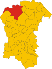
Civitella Casanova (Civitella Casanova)
.svg)
- Italian comune
 Hiking in Civitella Casanova
Civitella Casanova is a picturesque village in the Abruzzo region of Italy, known for its natural beauty, historical architecture, and stunning landscapes. Hiking in this area offers an opportunity to explore the scenic countryside, enjoy panoramic views, and experience the rich flora and fauna of the region.
Hiking Trails
-
Local Trail Networks: There are several well-marked trails around Civitella Casanova that cater to different skill levels. The trails often connect with nearby towns and natural sites, allowing hikers to immerse themselves in both nature and local culture.
-
Gran Sasso and Monti della Laga National Park: The nearby national park features more challenging hikes and stunning mountain scenery. From Civitella Casanova, you can access trails that lead into the park, where you can see vast alpine meadows, rocky peaks, and perhaps even some native wildlife.
-
Historical Routes: Some trails weave through historical sites, including ancient ruins and medieval towns, providing a cultural component to your hiking experience.
Recommendations for Hikers
-
Best Time to Hike: Late spring (May to June) and early autumn (September to October) are ideal for hiking. The weather is generally mild, and the landscapes are vibrant with wildflowers or autumn foliage.
-
Gear: Make sure to wear sturdy hiking boots, bring plenty of water, and dress in layers. Weather can change quickly in the mountains.
-
Navigation: While many trails are marked, it’s helpful to carry a map or use a hiking app for navigation.
-
Local Tips: Consider checking in with local hiking clubs or visitor centers for advice on current trail conditions and guided hikes for a more in-depth experience.
Safety Considerations
- Always inform someone about your planned route and expected return time.
- Be aware of the difficulty level of each trail and choose one that matches your experience and fitness levels.
- Watch for signs of wildlife, especially in more remote areas.
Hiking in Civitella Casanova can be a rewarding experience, blending natural beauty with historical charm. Whether you're looking for a leisurely stroll or a challenging trek, the area has something to offer for every outdoor enthusiast.
- Country:

- Postal Code: 65010
- Local Dialing Code: 085
- Licence Plate Code: PE
- Coordinates: 42° 22' 0" N, 13° 53' 0" E


- GPS tracks (wikiloc): [Link]
- AboveSeaLevel: 400 м m
- Area: 31.1 sq km
- Population: 1759
- Web site: http://www.comune.civitellacasanova.pe.it
- Wikipedia en: wiki(en)
- Wikipedia: wiki(it)
- Wikidata storage: Wikidata: Q51358
- Wikipedia Commons Category: [Link]
- Freebase ID: [/m/0fg8k]
- GeoNames ID: Alt: [6538864]
- OSM relation ID: [41983]
- TGN ID: [4002696]
- ISTAT ID: 068014
- Italian cadastre code: C779
Shares border with regions:


Ofena
- Italian comune
Hiking in Ofena
Ofena is a small village located in the Abruzzo region of Italy, known for its stunning landscapes and proximity to the Gran Sasso e Monti della Laga National Park. Hiking in this area offers a unique combination of picturesque views, diverse flora and fauna, and a rich cultural heritage....
- Country:
- Postal Code: 67025
- Local Dialing Code: 0862
- Licence Plate Code: AQ
- Coordinates: 42° 19' 36" N, 13° 45' 35" E
- GPS tracks (wikiloc): [Link]
- AboveSeaLevel: 531 м m
- Area: 36.9 sq km
- Population: 471
- Web site: [Link]


Carpineto della Nora
- Italian comune
Hiking in Carpineto della Nora
Carpineto della Nora, located in the Abruzzo region of Italy, offers a beautiful and varied terrain for hiking enthusiasts. The area is characterized by its picturesque landscapes, including mountains, forests, and scenic views of the surrounding countryside. Here are some key points about hiking in Carpineto della Nora:...
- Country:
- Postal Code: 65010
- Local Dialing Code: 085
- Licence Plate Code: PE
- Coordinates: 42° 20' 0" N, 13° 52' 0" E
- GPS tracks (wikiloc): [Link]
- AboveSeaLevel: 535 м m
- Area: 24.08 sq km
- Population: 623
- Web site: [Link]
Civitaquana
- Italian comune
Hiking in Civitaquana
Civitaquana, located in the Abruzzo region of Italy, offers an array of hiking opportunities for outdoor enthusiasts. Nestled in the Apennine Mountains, this charming village is surrounded by scenic landscapes, making it a fantastic destination for nature lovers. Here are some aspects to consider when hiking in Civitaquana:...
- Country:
- Postal Code: 65010
- Local Dialing Code: 085
- Licence Plate Code: PE
- Coordinates: 42° 20' 0" N, 13° 54' 0" E
- GPS tracks (wikiloc): [Link]
- AboveSeaLevel: 550 м m
- Area: 21.88 sq km
- Population: 1225
- Web site: [Link]


Loreto Aprutino
- Italian comune
Hiking in Loreto Aprutino
Loreto Aprutino is a charming town located in the Abruzzo region of Italy, known for its stunning landscapes, rolling hills, and proximity to both the mountains and the Adriatic coast. This area offers a variety of hiking opportunities suitable for different skill levels, all set against a backdrop of beautiful natural scenery and historical sites....
- Country:
- Postal Code: 65014
- Local Dialing Code: 085
- Licence Plate Code: PE
- Coordinates: 42° 26' 5" N, 13° 59' 1" E
- GPS tracks (wikiloc): [Link]
- AboveSeaLevel: 307 м m
- Area: 59.5 sq km
- Population: 7369
- Web site: [Link]
Montebello di Bertona
- Italian comune
Hiking in Montebello di Bertona
Montebello di Bertona is a beautiful destination for hikers, located in the Abruzzo region of Italy. Nestled in the Gran Sasso e Monti della Laga National Park, it offers a range of trails that showcase stunning landscapes, diverse flora and fauna, and breathtaking views of the surrounding mountains and valleys....
- Country:
- Postal Code: 65010
- Local Dialing Code: 085
- Licence Plate Code: PE
- Coordinates: 42° 25' 0" N, 13° 52' 0" E
- GPS tracks (wikiloc): [Link]
- AboveSeaLevel: 615 м m
- Area: 21.5 sq km
- Population: 945
- Web site: [Link]

Penne, Abruzzo
- Italian comune
Hiking in Penne, Abruzzo
Hiking in Penne, a charming town in the Abruzzo region of Italy, offers you a rich blend of natural beauty, historical significance, and cultural experiences. Here are some highlights and tips for hiking in this picturesque area:...
- Country:
- Postal Code: 65017
- Local Dialing Code: 085
- Licence Plate Code: PE
- Coordinates: 42° 27' 0" N, 13° 55' 0" E
- GPS tracks (wikiloc): [Link]
- AboveSeaLevel: 438 м m
- Area: 91.2 sq km
- Population: 12113
- Web site: [Link]
Vicoli
- Italian comune
Hiking in Vicoli
Vicoli is a small village located in the Abruzzo region of Italy, known for its beautiful landscapes, historical architecture, and proximity to the Apennine mountains. Hiking in this area can be a delightful experience for nature enthusiasts and adventurers....
- Country:
- Postal Code: 65010
- Local Dialing Code: 085
- Licence Plate Code: PE
- Coordinates: 42° 20' 0" N, 13° 54' 0" E
- GPS tracks (wikiloc): [Link]
- AboveSeaLevel: 445 м m
- Area: 9.33 sq km
- Population: 378
- Web site: [Link]


Villa Celiera
- Italian comune
Hiking in Villa Celiera
Villa Celiera, a picturesque town nestled in the Abruzzo region of Italy, offers a fantastic hiking experience for nature enthusiasts. The area is characterized by its stunning landscapes, including rolling hills, dense forests, and panoramic views of the Gran Sasso and Maiella mountain ranges. Here are some key aspects of hiking in and around Villa Celiera:...
- Country:
- Postal Code: 65010
- Local Dialing Code: 085
- Licence Plate Code: PE
- Coordinates: 42° 22' 49" N, 13° 51' 33" E
- GPS tracks (wikiloc): [Link]
- AboveSeaLevel: 714 м m
- Area: 13.18 sq km
- Population: 652
- Web site: [Link]