Oliveto Lario (Oliveto Lario)
.svg)
- Italian comune
 Hiking in Oliveto Lario
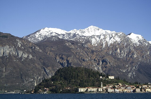
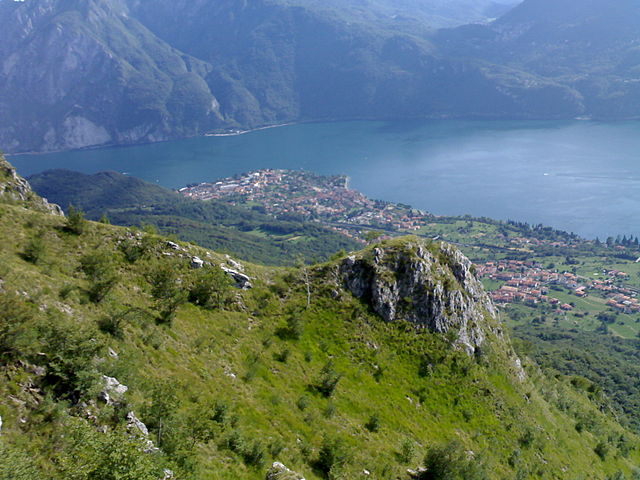
Oliveto Lario, located on the eastern shore of Lake Como in Italy, offers stunning landscapes and a rich assortment of hiking trails. The area is characterized by its picturesque views of the lake, charming villages, lush vegetation, and the surrounding mountains. Here are some highlights and tips for hiking in Oliveto Lario:
Hiking Trails
-
Sentiero del Viandante: This is a well-known hiking route that runs from Abbadia Lariana to Colico. It passes through Oliveto Lario and offers beautiful views of Lake Como. The trail is moderately challenging and can be divided into sections for easier exploration.
-
Monte Barro: For more experienced hikers, the trails leading to Monte Barro offer a steeper ascent and panoramic views of the surrounding areas, including the lake and the distant peaks of the Alps. The area is also home to diverse flora and fauna.
-
Via delle Montagne: This network connects several trails around the area and offers a mix of hiking experiences, from easy walks to more challenging treks. You can explore historical sites and enjoy the serene environment.
Landscape and Flora
Expect to see a mix of Mediterranean and alpine vegetation along the trails, including chestnut and oak forests, wildflowers, and local herbs. The views of Lake Como, surrounded by mountains, make for breathtaking scenery, especially during sunrise and sunset.
Tips for Hiking in Oliveto Lario
- Preparation: Be sure to wear appropriate hiking shoes, and carry enough water and snacks. Since trails can vary in difficulty, assess your fitness level and choose the trail that suits you best.
- Weather: Always check the weather forecast before heading out, as conditions can change rapidly, especially in mountainous areas.
- Map and Navigation: While many trails are well-marked, having a map or using a hiking app can help you stay oriented. It’s also a good idea to have a downloaded trail map in case you lose signal.
- Local Regulations: Respect local wildlife, plants, and regulations. Stick to designated trails and avoid disturbing natural habitats.
What to Bring
- Comfortable hiking shoes
- Weather-appropriate clothing (layering is recommended)
- Water and snacks
- Sunscreen and a hat
- A backpack for personal items and gear
Conclusion
Hiking in Oliveto Lario is a fantastic way to experience the natural beauty of Lake Como and the surrounding mountains. Whether you are an experienced hiker or just looking for a leisurely stroll, you'll find a trail that suits your needs and offers unforgettable views.
- Country:

- Postal Code: 23865
- Local Dialing Code: 031
- Licence Plate Code: LC
- Coordinates: 45° 57' 0" N, 9° 16' 0" E


- GPS tracks (wikiloc): [Link]
- AboveSeaLevel: 208 м m
- Area: 15.7 sq km
- Population: 1227
- Web site: http://www.comune.olivetolario.lc.it/
- Wikipedia en: wiki(en)
- Wikipedia: wiki(it)
- Wikidata storage: Wikidata: Q42221
- Wikipedia Commons Category: [Link]
- Freebase ID: [/m/0gr48r]
- GeoNames ID: Alt: [6536413]
- VIAF ID: Alt: [237974263]
- OSM relation ID: [46451]
- archINFORM location ID: [958]
- ISTAT ID: 097060
- Italian cadastre code: G040
Shares border with regions:
Barni
- Italian comune
Hiking in Barni
Barni is a charming village located in the Lombardy region of Italy, near Lake Como. It is surrounded by beautiful natural landscapes, making it an excellent destination for hiking enthusiasts. Here are some highlights and tips for hiking in and around Barni:...
- Country:
- Postal Code: 22030
- Local Dialing Code: 031
- Licence Plate Code: CO
- Coordinates: 45° 55' 0" N, 9° 16' 0" E
- GPS tracks (wikiloc): [Link]
- AboveSeaLevel: 635 м m
- Area: 5.72 sq km
- Population: 582
- Web site: [Link]

Bellagio
- Italian comune
Hiking in Bellagio
Bellagio, located in Lombardy, Italy, is a picturesque town situated on the shores of Lake Como, famous for its stunning landscapes and charming architecture. Hiking in this area offers a wonderful way to experience the natural beauty and panoramic views of the lake and surrounding mountains. Here are some key points about hiking in Bellagio:...
- Country:
- Postal Code: 22021
- Local Dialing Code: 031
- Licence Plate Code: CO
- Coordinates: 45° 59' 15" N, 9° 15' 43" E
- GPS tracks (wikiloc): [Link]
- AboveSeaLevel: 229 м m
- Area: 29.06 sq km
- Population: 3747
- Web site: [Link]

Abbadia Lariana
- Italian comune in the Province of Lecco
Hiking in Abbadia Lariana
Abbadia Lariana is a charming village located on the eastern shore of Lake Como in Italy, and it offers a variety of hiking opportunities ranging from easy walks to more challenging trails. The region is characterized by its stunning natural scenery, including lush forests, rugged mountains, and beautiful lake views....
- Country:
- Postal Code: 23821
- Local Dialing Code: 0341
- Licence Plate Code: LC
- Coordinates: 45° 54' 0" N, 9° 20' 0" E
- GPS tracks (wikiloc): [Link]
- AboveSeaLevel: 204 м m
- Area: 16.67 sq km
- Population: 3216
- Web site: [Link]

Varenna
- Italian comune
Hiking in Varenna
Varenna, a picturesque village on the eastern shore of Lake Como in Italy, is an excellent destination for hiking enthusiasts. The area offers a beautiful mix of natural beauty, cultural heritage, and well-maintained trails....
- Country:
- Postal Code: 23829
- Local Dialing Code: 0341
- Licence Plate Code: LC
- Coordinates: 46° 0' 39" N, 9° 17' 2" E
- GPS tracks (wikiloc): [Link]
- AboveSeaLevel: 220 м m
- Area: 12.57 sq km
- Population: 739
- Web site: [Link]


Mandello del Lario
- Italian comune
Hiking in Mandello del Lario
Mandello del Lario, located on the eastern shore of Lake Como in Italy, offers stunning landscapes, rich history, and a variety of hiking opportunities that cater to different levels of experience. Here are some highlights of hiking in this beautiful region:...
- Country:
- Postal Code: 23826
- Local Dialing Code: 0341
- Licence Plate Code: LC
- Coordinates: 45° 55' 0" N, 9° 19' 0" E
- GPS tracks (wikiloc): [Link]
- AboveSeaLevel: 200 м m
- Area: 43.33 sq km
- Population: 10313
- Web site: [Link]


Lierna
- Italian comune
Hiking in Lierna
Lierna, a picturesque town on the shores of Lake Como in Italy, offers some beautiful hiking opportunities that showcase stunning landscapes, historical sites, and the scenic beauty of the area. Here are some key aspects to consider when hiking in and around Lierna:...
- Country:
- Postal Code: 23827
- Local Dialing Code: 0341
- Licence Plate Code: LC
- Coordinates: 45° 57' 29" N, 9° 18' 18" E
- GPS tracks (wikiloc): [Link]
- AboveSeaLevel: 202 м m
- Area: 11.24 sq km
- Population: 2122
- Web site: [Link]
Lasnigo
- Italian comune
Hiking in Lasnigo
Lasnigo is a charming town in the Lombardy region of Italy, nestled in the foothills of the Italian Alps. It's a less-known gem for hiking enthusiasts, offering a range of trails that showcase the stunning natural beauty of the area, characterized by lush forests, breathtaking views, and picturesque landscapes....
- Country:
- Postal Code: 22030
- Local Dialing Code: 031
- Licence Plate Code: CO
- Coordinates: 45° 53' 0" N, 9° 16' 0" E
- GPS tracks (wikiloc): [Link]
- AboveSeaLevel: 570 м m
- Area: 5.53 sq km
- Population: 475
- Web site: [Link]

Magreglio
- Italian comune
Hiking in Magreglio
Magreglio, a charming village located in the region of Lombardy in northern Italy, offers a delightful hiking experience for outdoor enthusiasts. Nestled in the hills above Lake Como, Magreglio serves as a gateway to stunning landscapes, lush forests, and breathtaking views of the surrounding mountains and lake....
- Country:
- Postal Code: 22030
- Local Dialing Code: 031
- Licence Plate Code: CO
- Coordinates: 45° 55' 0" N, 9° 16' 0" E
- GPS tracks (wikiloc): [Link]
- AboveSeaLevel: 658 м m
- Area: 3.08 sq km
- Population: 667
- Web site: [Link]
Valbrona
- Italian comune
Hiking in Valbrona
Valbrona, located in the Lombardy region of Italy, is a picturesque area near Lake Como, offering stunning landscapes and a variety of hiking opportunities. Here are some insights into hiking in Valbrona:...
- Country:
- Postal Code: 22039
- Local Dialing Code: 031
- Licence Plate Code: CO
- Coordinates: 45° 52' 0" N, 9° 18' 0" E
- GPS tracks (wikiloc): [Link]
- AboveSeaLevel: 494 м m
- Area: 13.65 sq km
- Population: 2652
- Web site: [Link]