
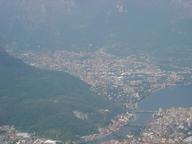
Mandello del Lario (Mandello del Lario)
.svg)
- Italian comune
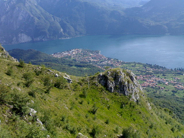
 Hiking in Mandello del Lario
Mandello del Lario, located on the eastern shore of Lake Como in Italy, offers stunning landscapes, rich history, and a variety of hiking opportunities that cater to different levels of experience. Here are some highlights of hiking in this beautiful region:
Trails and Routes
-
Sentiero del Fiume Merone: This scenic trail follows the Merone River and is relatively easy, making it suitable for families and novice hikers. You can enjoy beautiful views of the river and surrounding forests.
-
Sentiero del Viandante: This historic path runs along the eastern shore of Lake Como, connecting various towns and offering breathtaking views of the lake and mountains. Parts of this trail pass through Mandello del Lario, and it's suitable for those with a moderate level of fitness.
-
Monte Resegone: For more experienced hikers, the trek to Monte Resegone provides a rewarding challenge. The views from the summit are spectacular, offering panoramic vistas of the surrounding Alps and Lake Como. There are several routes to the top, ranging from moderate to difficult.
-
Colle di Balisio: From Mandello del Lario, you can hike up to the Balisio Hill for a more leisurely hike that rewards you with beautiful views without being overly strenuous.
Important Considerations
-
Weather: Always check the weather conditions before heading out. The weather can change rapidly in the mountains, so it’s important to be prepared.
-
Gear: Wear appropriate hiking footwear, carry enough water, snacks, and a first aid kit. Depending on the trail and the season, consider bringing trekking poles or additional gear.
-
Local Regulations: Respect the natural environment and local regulations regarding trail use. It's advisable to stick to marked paths and not disturb wildlife.
-
Guided Tours: If you prefer a guided experience, there are local hiking organizations that offer guided tours and insights about the area’s natural and historical significance.
Attractions Nearby
After a day of hiking, you can explore the charming town of Mandello del Lario, known for its historic buildings, including the Basilica of San Lorenzo and the picturesque waterfront along Lake Como. Additionally, consider visiting local eateries to enjoy traditional Italian cuisine.
Mandello del Lario's mix of stunning hikes and beautiful scenery make it a wonderful destination for both seasoned hikers and those looking to enjoy nature at a more relaxed pace.
- Country:

- Postal Code: 23826
- Local Dialing Code: 0341
- Licence Plate Code: LC
- Coordinates: 45° 55' 0" N, 9° 19' 0" E


- GPS tracks (wikiloc): [Link]
- AboveSeaLevel: 200 м m
- Area: 43.33 sq km
- Population: 10313
- Web site: http://www.mandellolario.it
- Wikipedia en: wiki(en)
- Wikipedia: wiki(it)
- Wikidata storage: Wikidata: Q42935
- Wikipedia Commons Gallery: [Link]
- Wikipedia Commons Category: [Link]
- Freebase ID: [/m/0cwzl6]
- GeoNames ID: Alt: [6541782]
- VIAF ID: Alt: [129165357]
- OSM relation ID: [46388]
- Quora topic ID: [Mandello-Del-Lario]
- TGN ID: [1045215]
- UN/LOCODE: [ITMLL]
- Gran Enciclopèdia Catalana ID: [0265866]
- ISTAT ID: 097046
- Italian cadastre code: E879
Shares border with regions:


Pasturo
- Italian comune
Hiking in Pasturo
Pasturo is a charming village located in the Lombardy region of Italy, nestled within the beautiful landscapes of the Valsassina valley. It's a great destination for hiking enthusiasts, offering various trails that showcase the natural beauty of the area, including stunning views of mountains, lush forests, and local wildlife....
- Country:
- Postal Code: 23818
- Local Dialing Code: 0341
- Licence Plate Code: LC
- Coordinates: 45° 57' 0" N, 9° 26' 0" E
- GPS tracks (wikiloc): [Link]
- AboveSeaLevel: 641 м m
- Area: 21.78 sq km
- Population: 1993
- Web site: [Link]
Oliveto Lario
- Italian comune
Hiking in Oliveto Lario
Oliveto Lario, located on the eastern shore of Lake Como in Italy, offers stunning landscapes and a rich assortment of hiking trails. The area is characterized by its picturesque views of the lake, charming villages, lush vegetation, and the surrounding mountains. Here are some highlights and tips for hiking in Oliveto Lario:...
- Country:
- Postal Code: 23865
- Local Dialing Code: 031
- Licence Plate Code: LC
- Coordinates: 45° 57' 0" N, 9° 16' 0" E
- GPS tracks (wikiloc): [Link]
- AboveSeaLevel: 208 м m
- Area: 15.7 sq km
- Population: 1227
- Web site: [Link]

Abbadia Lariana
- Italian comune in the Province of Lecco
Hiking in Abbadia Lariana
Abbadia Lariana is a charming village located on the eastern shore of Lake Como in Italy, and it offers a variety of hiking opportunities ranging from easy walks to more challenging trails. The region is characterized by its stunning natural scenery, including lush forests, rugged mountains, and beautiful lake views....
- Country:
- Postal Code: 23821
- Local Dialing Code: 0341
- Licence Plate Code: LC
- Coordinates: 45° 54' 0" N, 9° 20' 0" E
- GPS tracks (wikiloc): [Link]
- AboveSeaLevel: 204 м m
- Area: 16.67 sq km
- Population: 3216
- Web site: [Link]
Ballabio
- Italian comune
Hiking in Ballabio
Ballabio, located in the Lombardy region of Italy, is a charming mountain village situated near the Lecco area and is an excellent destination for hiking enthusiasts. The surrounding mountains, particularly the Grigna range, offer a variety of trails suited for different skill levels, from easy walks to more challenging ascents....
- Country:
- Postal Code: 23811
- Local Dialing Code: 0341
- Licence Plate Code: LC
- Coordinates: 45° 54' 0" N, 9° 25' 0" E
- GPS tracks (wikiloc): [Link]
- AboveSeaLevel: 661 м m
- Area: 15.04 sq km
- Population: 4052
- Web site: [Link]

Valmadrera
- Italian comune
Hiking in Valmadrera
Valmadrera is a charming town located in the province of Lecco, in the Lombardy region of Italy. It is situated near the eastern shore of Lake Como and is surrounded by beautiful natural landscapes, making it a great destination for hiking enthusiasts. Here are some key highlights about hiking in Valmadrera:...
- Country:
- Postal Code: 23868
- Local Dialing Code: 0341
- Licence Plate Code: LC
- Coordinates: 45° 50' 47" N, 9° 21' 30" E
- GPS tracks (wikiloc): [Link]
- AboveSeaLevel: 234 м m
- Area: 12.6 sq km
- Population: 11601
- Web site: [Link]


Lierna
- Italian comune
Hiking in Lierna
Lierna, a picturesque town on the shores of Lake Como in Italy, offers some beautiful hiking opportunities that showcase stunning landscapes, historical sites, and the scenic beauty of the area. Here are some key aspects to consider when hiking in and around Lierna:...
- Country:
- Postal Code: 23827
- Local Dialing Code: 0341
- Licence Plate Code: LC
- Coordinates: 45° 57' 29" N, 9° 18' 18" E
- GPS tracks (wikiloc): [Link]
- AboveSeaLevel: 202 м m
- Area: 11.24 sq km
- Population: 2122
- Web site: [Link]

Esino Lario
- ancient village of Lake Como
Hiking in Esino Lario
Esino Lario, located in the Lombardy region of Italy, is a beautiful destination for hikers, offering stunning views of the surrounding mountains and Lake Como. The village is situated at an altitude of about 1,000 meters (3,300 feet), making it a fantastic starting point for various hiking trails. Here’s an overview of what to expect when hiking in Esino Lario:...
- Country:
- Postal Code: 23825
- Local Dialing Code: 0341
- Coordinates: 45° 59' 38" N, 9° 19' 59" E
- GPS tracks (wikiloc): [Link]
- AboveSeaLevel: 910 м m
- Area: 18.05 sq km
- Population: 747
- Web site: [Link]
Valbrona
- Italian comune
Hiking in Valbrona
Valbrona, located in the Lombardy region of Italy, is a picturesque area near Lake Como, offering stunning landscapes and a variety of hiking opportunities. Here are some insights into hiking in Valbrona:...
- Country:
- Postal Code: 22039
- Local Dialing Code: 031
- Licence Plate Code: CO
- Coordinates: 45° 52' 0" N, 9° 18' 0" E
- GPS tracks (wikiloc): [Link]
- AboveSeaLevel: 494 м m
- Area: 13.65 sq km
- Population: 2652
- Web site: [Link]


Lecco
- Italian comune
Hiking in Lecco
Lecco, located in the Lombardy region of northern Italy, is a fantastic destination for hiking enthusiasts. Nestled at the southeastern tip of Lake Como, it offers stunning natural landscapes, diverse trails, and breathtaking views of the surrounding mountains, including the Grigna and Resegone ranges....
- Country:
- Postal Code: 23900
- Local Dialing Code: 0341
- Licence Plate Code: LC
- Coordinates: 45° 51' 0" N, 9° 24' 0" E
- GPS tracks (wikiloc): [Link]
- AboveSeaLevel: 214 м m
- Area: 45.14 sq km
- Population: 48177
- Web site: [Link]