Orsennes (Orsennes)

- commune in Indre, France
- Country:

- Postal Code: 36190
- Coordinates: 46° 28' 33" N, 1° 40' 58" E


- GPS tracks (wikiloc): [Link]
- Area: 49.28 sq km
- Population: 772
- Web site: http://orsennes.freeheberg.com
- Wikipedia en: wiki(en)
- Wikipedia: wiki(fr)
- Wikidata storage: Wikidata: Q935517
- Wikipedia Commons Category: [Link]
- Freebase ID: [/m/0c090x]
- GeoNames ID: Alt: [6432936]
- SIREN number: [213601461]
- BnF ID: [15257450k]
- VIAF ID: Alt: [260034360]
- INSEE municipality code: 36146
Shares border with regions:


Saint-Plantaire
- commune in Indre, France
- Country:
- Postal Code: 36190
- Coordinates: 46° 27' 26" N, 1° 40' 13" E
- GPS tracks (wikiloc): [Link]
- Area: 34.07 sq km
- Population: 584
- Web site: [Link]


Maillet
- commune in Indre, France
- Country:
- Postal Code: 36340
- Coordinates: 46° 34' 24" N, 1° 40' 43" E
- GPS tracks (wikiloc): [Link]
- Area: 25.02 sq km
- Population: 266


Pommiers
- commune in Indre, France
- Country:
- Postal Code: 36190
- Coordinates: 46° 31' 23" N, 1° 39' 23" E
- GPS tracks (wikiloc): [Link]
- Area: 12.19 sq km
- Population: 261
Méasnes
- commune in Creuse, France
- Country:
- Postal Code: 23360
- Coordinates: 46° 24' 59" N, 1° 46' 40" E
- GPS tracks (wikiloc): [Link]
- Area: 27.63 sq km
- Population: 552


Gargilesse-Dampierre
- commune in Indre, France
- Country:
- Postal Code: 36190
- Coordinates: 46° 30' 49" N, 1° 35' 49" E
- GPS tracks (wikiloc): [Link]
- Area: 15.72 sq km
- Population: 299
- Web site: [Link]

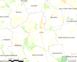
Cluis
- commune in Indre, France
- Country:
- Postal Code: 36340
- Coordinates: 46° 32' 42" N, 1° 44' 55" E
- GPS tracks (wikiloc): [Link]
- Area: 35.32 sq km
- Population: 1000
- Web site: [Link]


Montchevrier
- commune in Indre, France
- Country:
- Postal Code: 36140
- Coordinates: 46° 28' 50" N, 1° 44' 33" E
- GPS tracks (wikiloc): [Link]
- Area: 34.7 sq km
- Population: 459


Malicornay
- commune in Indre, France
- Country:
- Postal Code: 36340
- Coordinates: 46° 34' 32" N, 1° 38' 49" E
- GPS tracks (wikiloc): [Link]
- Area: 16.31 sq km
- Population: 185

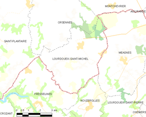
Lourdoueix-Saint-Michel
- commune in Indre, France
- Country:
- Postal Code: 36140
- Coordinates: 46° 25' 36" N, 1° 43' 48" E
- GPS tracks (wikiloc): [Link]
- Area: 19.67 sq km
- Population: 325