Méasnes (Méasnes)

- commune in Creuse, France
- Country:

- Postal Code: 23360
- Coordinates: 46° 24' 59" N, 1° 46' 40" E


- GPS tracks (wikiloc): [Link]
- Area: 27.63 sq km
- Population: 552
- Wikipedia en: wiki(en)
- Wikipedia: wiki(fr)
- Wikidata storage: Wikidata: Q495656
- Wikipedia Commons Category: [Link]
- Freebase ID: [/m/03mfjvl]
- Freebase ID: [/m/03mfjvl]
- GeoNames ID: Alt: [6429225]
- GeoNames ID: Alt: [6429225]
- SIREN number: [212313001]
- SIREN number: [212313001]
- VIAF ID: Alt: [305328496]
- VIAF ID: Alt: [305328496]
- INSEE municipality code: 23130
- INSEE municipality code: 23130
Shares border with regions:
Nouzerolles
- commune in Creuse, France
- Country:
- Postal Code: 23360
- Coordinates: 46° 22' 54" N, 1° 44' 30" E
- GPS tracks (wikiloc): [Link]
- Area: 8.17 sq km
- Population: 103


Lourdoueix-Saint-Pierre
- commune in Creuse, France
- Country:
- Postal Code: 23360
- Coordinates: 46° 24' 35" N, 1° 49' 20" E
- GPS tracks (wikiloc): [Link]
- Area: 44.73 sq km
- Population: 779

Aigurande
- commune in Indre, France
- Country:
- Postal Code: 36140
- Coordinates: 46° 26' 3" N, 1° 49' 44" E
- GPS tracks (wikiloc): [Link]
- Area: 27.77 sq km
- Population: 1458
- Web site: [Link]


Montchevrier
- commune in Indre, France
- Country:
- Postal Code: 36140
- Coordinates: 46° 28' 50" N, 1° 44' 33" E
- GPS tracks (wikiloc): [Link]
- Area: 34.7 sq km
- Population: 459

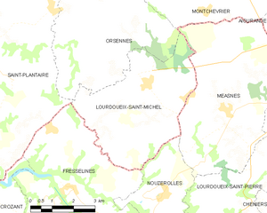
Lourdoueix-Saint-Michel
- commune in Indre, France
- Country:
- Postal Code: 36140
- Coordinates: 46° 25' 36" N, 1° 43' 48" E
- GPS tracks (wikiloc): [Link]
- Area: 19.67 sq km
- Population: 325


Orsennes
- commune in Indre, France
- Country:
- Postal Code: 36190
- Coordinates: 46° 28' 33" N, 1° 40' 58" E
- GPS tracks (wikiloc): [Link]
- Area: 49.28 sq km
- Population: 772
- Web site: [Link]