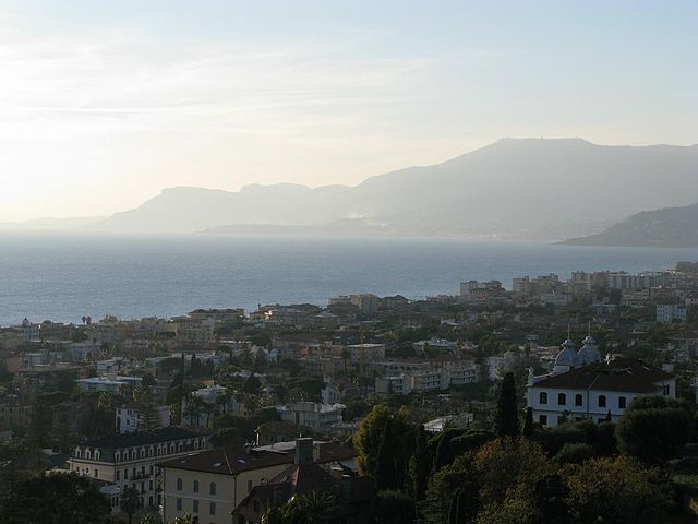
Ospedaletti (Ospedaletti)
.svg)
- Italian comune
 Hiking in Ospedaletti
Ospedaletti, located along the Italian Riviera near the French border in the region of Liguria, offers beautiful coastal landscapes, charming towns, and access to a variety of hiking trails. Here are some highlights about hiking in and around Ospedaletti:
Scenic Trails
-
Coastal Paths: The area features stunning coastal paths with breathtaking views of the Mediterranean Sea. The trail connecting Ospedaletti to Sanremo is popular, offering picturesque panoramas, cliffside scenery, and opportunities for swimming in secluded coves.
-
Hilly Terrain: Ospedaletti is situated at the foot of the hills, providing access to trails that climb into the surrounding hills. These trails offer more challenging hikes with rewarding views over the coastline and the surrounding landscape.
-
Olive Groves and Vineyards: Many trails pass through beautiful olive groves and vineyards, allowing hikers to experience the local agriculture and perhaps stop for tastings at family-run farms along the way.
Popular Routes
- Via Porrine: This is one of the well-known hiking routes that connects Ospedaletti to nearby towns. It is ideal for both casual walkers and more experienced hikers.
- San Romolo Trail: Leading from Ospedaletti upwards to the village of San Romolo, this trail offers a moderate hike with lovely views and opportunities to see local flora and fauna.
Additional Tips
- Best Time to Hike: Spring and fall are the best seasons for hiking in this region, as the weather is mild and the trails are less crowded. Summers can be hot, and winter could bring some rain and cooler temperatures.
- Preparation: As always, make sure to wear suitable hiking shoes, carry plenty of water, and have sun protection. Even on well-marked trails, a map or downloading trail apps can be helpful.
Other Activities
Besides hiking, Ospedaletti offers a lovely beach, quaint cafes, and restaurants where you can sample local cuisine after your hikes. The blend of outdoor adventures and culinary delights makes it a well-rounded destination for both nature lovers and food enthusiasts.
Overall, Ospedaletti can provide a wonderful experience for hikers of all levels, surrounded by the natural beauty of the Italian Riviera.
- Country:

- Postal Code: 18014
- Local Dialing Code: 0184
- Licence Plate Code: IM
- Coordinates: 43° 48' 2" N, 7° 43' 4" E


- GPS tracks (wikiloc): [Link]
- AboveSeaLevel: 5 м m
- Area: 5.45 sq km
- Population: 3292
- Web site: http://www.comune.ospedaletti.im.it/
- Wikipedia en: wiki(en)
- Wikipedia: wiki(it)
- Wikidata storage: Wikidata: Q269458
- Wikipedia Commons Category: [Link]
- Freebase ID: [/m/0gbyw1]
- GeoNames ID: Alt: [6537042]
- VIAF ID: Alt: [139740728]
- OSM relation ID: [42641]
- UN/LOCODE: [ITOPD]
- ISTAT ID: 008039
- Italian cadastre code: G164
Shares border with regions:

Bordighera
- Italian comune
Hiking in Bordighera
Bordighera, located on the Italian Riviera in the Liguria region, offers a variety of scenic hiking opportunities that can cater to different skill levels. Here are some highlights and tips for hiking in and around Bordighera:...
- Country:
- Postal Code: 18012
- Local Dialing Code: 0184
- Licence Plate Code: IM
- Coordinates: 43° 46' 44" N, 7° 40' 20" E
- GPS tracks (wikiloc): [Link]
- AboveSeaLevel: 5 м m
- Area: 10.65 sq km
- Population: 10412
- Web site: [Link]
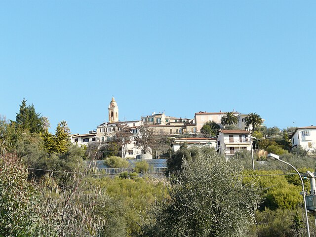

Seborga
- Italian comune
Hiking in Seborga
Seborga is a charming village located in the Italian Riviera, within the province of Imperia in the Liguria region. Known for its picturesque views, historic architecture, and a rich cultural history, Seborga also offers a variety of hiking opportunities for outdoor enthusiasts. Here’s what you need to know about hiking in and around Seborga:...
- Country:
- Postal Code: 18012
- Local Dialing Code: 0184
- Licence Plate Code: IM
- Coordinates: 43° 49' 34" N, 7° 41' 38" E
- GPS tracks (wikiloc): [Link]
- AboveSeaLevel: 500 м m
- Area: 4.87 sq km
- Population: 297
- Web site: [Link]


Vallebona
- Italian comune
Hiking in Vallebona
Vallebona is a picturesque village located in the Italian region of Liguria, near the French border. Nestled in the hills above the coastline, it offers stunning views of the surrounding countryside and the Ligurian Sea. Hiking in the area around Vallebona can be a rewarding experience, as it encompasses a mix of natural beauty, cultural heritage, and diverse trails....
- Country:
- Postal Code: 18012
- Local Dialing Code: 0184
- Licence Plate Code: IM
- Coordinates: 43° 48' 44" N, 7° 39' 55" E
- GPS tracks (wikiloc): [Link]
- AboveSeaLevel: 149 м m
- Area: 5.88 sq km
- Population: 1319
- Web site: [Link]


Sanremo
- Italian comune
Hiking in Sanremo
Sanremo, located on the Italian Riviera in the region of Liguria, is well-known for its beautiful landscapes, mild climate, and stunning coastal views. Hiking in and around Sanremo offers a wonderful opportunity to explore the natural beauty of the area, from the Mediterranean coast to the surrounding hills and mountains. Here are some highlights and tips for hiking in Sanremo:...
- Country:
- Postal Code: 18038
- Local Dialing Code: 0184
- Licence Plate Code: IM
- Coordinates: 43° 49' 17" N, 7° 47' 12" E
- GPS tracks (wikiloc): [Link]
- AboveSeaLevel: 15 м m
- Area: 55.96 sq km
- Population: 54824
- Web site: [Link]