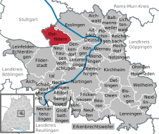
Ostfildern (Ostfildern)
- town in Baden-Württemberg, Germany
Ostfildern, located in the state of Baden-Württemberg, Germany, is a great destination for hiking enthusiasts. While it is primarily a suburban area, it is surrounded by beautiful natural landscapes that offer various hiking opportunities.
Hiking Areas in and around Ostfildern
-
Esslingen Valley (Neckar): Just a short distance from Ostfildern, the Esslingen Valley is a picturesque region with trails that wind along the river, providing scenic views and a peaceful atmosphere. The paths here accommodate different skill levels.
-
Nature Reserves: The nearby nature reserves, such as the "Waldgebiet Schönbuch," offer a variety of hiking trails through forests, meadows, and hills. The Schönbuch Nature Park is particularly known for its diverse flora and fauna.
-
Filder Plateau: This plateau, which encompasses parts of Ostfildern, features several well-marked trails that allow hikers to enjoy panoramic views of the surrounding landscape. It also includes vineyards and agricultural fields.
-
Local Parks and Areas: Ostfildern has several parks and green areas where you can enjoy short hikes or leisurely walks, such as the local parks in the neighborhoods or the Kiener Park.
Hiking Tips
- Trail Maps: Before heading out, it's helpful to consult local resources or maps for the best trails that suit your experience level.
- Weather Preparation: Always check the weather conditions before your hike and dress accordingly, as conditions can change quickly.
- Stay Hydrated: Carry enough water, especially during longer hikes.
- Footwear: Wear proper hiking boots for better traction and support.
Events and Community
Ostfildern may host various local events such as hiking groups or guided tours. Participating in these can enhance your experience and help you discover hidden gems in the area.
Conclusion
Hiking in Ostfildern allows you to explore the beauty of the Baden-Württemberg countryside while enjoying the convenience of being near urban amenities. Whether you're looking for a leisurely stroll or a more challenging hike, you are sure to find suitable paths to take in the natural beauty around Ostfildern.
- Country:

- Postal Code: 73760
- Local Dialing Code: 07158; 0711
- Licence Plate Code: ES
- Coordinates: 48° 43' 22" N, 9° 15' 47" E


- GPS tracks (wikiloc): [Link]
- AboveSeaLevel: 348 м m
- Area: 22.81 sq km
- Population: 37785
- Web site: http://www.ostfildern.de
- Wikipedia en: wiki(en)
- Wikipedia: wiki(de)
- Wikidata storage: Wikidata: Q14916
- Wikipedia Commons Category: [Link]
- Freebase ID: [/m/0djc8z]
- GeoNames ID: Alt: [2856307]
- VIAF ID: Alt: [127962462]
- OSM relation ID: [2793022]
- GND ID: Alt: [4044060-6]
- archINFORM location ID: [5687]
- MusicBrainz area ID: [0f1512fe-6a7e-4665-95e7-7ba486415571]
- WOEID: [683762]
- Quora topic ID: [Ostfildern]
- TGN ID: [4005072]
- German municipality key: 08116080
Includes regions:
Parksiedlung
- quarter of Ostfildern, Baden-Württemberg, Germany
Parksiedlung, while not widely known as a major hiking destination, is situated in Germany and offers various outdoor activities, including hiking, thanks to its proximity to nature reserves and beautiful landscapes. Here are some general tips and information for hiking in the Parksiedlung area:...
- Country:

- Postal Code: 73760
- Local Dialing Code: 0711
- Coordinates: 48° 43' 37" N, 9° 16' 12" E


- GPS tracks (wikiloc): [Link]
- AboveSeaLevel: 395 м m
Scharnhauser Park
- quarter of Ostfildern, Baden-Württemberg, Germany
Scharnhauser Park is a lovely area located in the district of Ostfildern in Germany, near Stuttgart. While it may not be known for extensive or rugged hiking trails like some of Germany's national parks, it does offer a variety of walking paths and recreational opportunities that can be enjoyed by hikers of all levels....
- Country:

- Postal Code: 73760
- Local Dialing Code: 0711
- Coordinates: 48° 43' 19" N, 9° 16' 12" E


- GPS tracks (wikiloc): [Link]
Kemnat
- quarter of Ostfildern, Baden-Württemberg, Germany
Kemnat, a district within Ostfildern in Germany, offers a blend of natural beauty and proximity to urban amenities, making it a great spot for hiking enthusiasts. While Kemnat itself might not be as widely recognized for hiking as some larger natural reserves, there are several trails and scenic areas in and around the district that provide enjoyable hiking experiences....
- Country:

- Postal Code: 73760
- Local Dialing Code: 0711
- Coordinates: 48° 43' 12" N, 9° 13' 48" E


- GPS tracks (wikiloc): [Link]
- AboveSeaLevel: 406 м m
Nellingen auf den Fildern
- quarter of Ostfildern, Baden-Württemberg, Germany
 Hiking in Nellingen auf den Fildern
Nellingen auf den Fildern, located in Baden-Württemberg, Germany, offers a number of hiking opportunities, particularly because it is situated near the scenic Swabian Jura and the Filder Plateau. The region combines natural beauty with cultural heritage, making it ideal for outdoor enthusiasts....
- Country:

- Postal Code: 73760
- Local Dialing Code: 0711
- Coordinates: 48° 42' 54" N, 9° 18' 0" E


- GPS tracks (wikiloc): [Link]
- AboveSeaLevel: 349 м m
Ruit
- quarter of Ostfildern, Baden-Württemberg, Germany
Ruit, a district within Ostfildern, Germany, is surrounded by picturesque landscapes and offers various hiking opportunities, making it an excellent location for outdoor enthusiasts. Here are some details about hiking in Ruit and the surrounding areas:...
- Country:

- Postal Code: 73760
- Local Dialing Code: 0711
- Coordinates: 48° 43' 44" N, 9° 15' 8" E


- GPS tracks (wikiloc): [Link]
- AboveSeaLevel: 411 м m
Scharnhausen
- quarter of Ostfildern, Baden-Württemberg, Germany
Scharnhausen is a district within the city of Esslingen am Neckar in Germany. While it's primarily known for its residential areas and proximity to urban amenities, it is also situated near some beautiful hiking trails that take you through the scenic landscapes of the surrounding Swabian Jura and the Neckar Valley....
- Country:

- Postal Code: 73760
- Local Dialing Code: 07158
- Coordinates: 48° 42' 31" N, 9° 15' 51" E


- GPS tracks (wikiloc): [Link]
- AboveSeaLevel: 305 м m
