
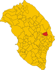
Otranto (Otranto)
- Italian comune
 Hiking in Otranto
Otranto, a stunning coastal town in the Puglia region of Italy, offers a variety of hiking opportunities that showcase its breathtaking landscapes, rich history, and vibrant Mediterranean culture. Here are some key points to consider when planning a hiking adventure in and around Otranto:
Scenic Trails
-
Coastal Path: The coastline near Otranto is dotted with scenic paths that provide breathtaking views of the Adriatic Sea. The trails along the cliffs offer picturesque spots for photography and peaceful moments by the water. The route to places like the Faraglioni di Santa Maria di Leuca is particularly stunning.
-
Natural Parks: Nearby natural parks, such as the Parco Naturale Regionale Costa Otranto - Santa Maria di Leuca, provide a wealth of hiking trails through diverse landscapes, including forests, coastal cliffs, and Mediterranean scrub. These trails cater to various skill levels and lead to beautiful spots for picnicking and enjoying nature.
-
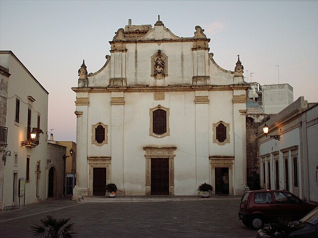
Historic Trails: Hiking in Otranto is unique due to its mix of nature and history. Certain trails lead to ancient sites, including the Otranto Cathedral, with its impressive mosaics, and the Castello Aragonese. Exploring these paths allows hikers to immerse themselves in the region's culture and history.
Tips for Hiking in Otranto
-
Best Time to Hike: The ideal seasons for hiking in Otranto are spring (March to June) and fall (September to November), when the weather is mild and the landscapes are vibrant.
-
Gear and Safety: Wear proper hiking shoes, bring plenty of water, and consider sun protection, especially during the summer months. Some trails may require moderate fitness levels, so choose routes that match your skill set.
-
Local Guidance: If you're unfamiliar with the area, consider joining guided hikes. Local guides can provide insights into the region's flora, fauna, and history, enhancing your experience.
-
Respect Nature: Remember to follow Leave No Trace principles to preserve the natural beauty of the area. Stay on marked trails and respect local wildlife.
Conclusion
Hiking in Otranto is an excellent way to explore the captivating landscapes and rich heritage of Puglia. With its combination of coastal beauty, historical significance, and natural parks, Otranto offers a rewarding experience for hikers of all levels. Whether you prefer leisurely coastal strolls or challenging trails, Otranto has something to offer every nature enthusiast.
- Country:

- Postal Code: 73028
- Local Dialing Code: 0836
- Licence Plate Code: LE
- Coordinates: 40° 9' 0" N, 18° 29' 0" E


- GPS tracks (wikiloc): [Link]
- AboveSeaLevel: 15 м m
- Area: 77.2 sq km
- Population: 5799
- Web site: http://www.comune.otranto.le.it
- Wikipedia en: wiki(en)
- Wikipedia: wiki(it)
- Wikidata storage: Wikidata: Q52174
- Wikipedia Commons Gallery: [Link]
- Wikipedia Commons Category: [Link]
- Wikipedia Commons Maps Category: [Link]
- Freebase ID: [/m/014mjr]
- GeoNames ID: Alt: [6541266]
- VIAF ID: Alt: [157095547]
- OSM relation ID: [40266]
- GND ID: Alt: [4044150-7]
- archINFORM location ID: [1013]
- Library of Congress authority ID: Alt: [n79097444]
- MusicBrainz area ID: [1d0fe47c-49c0-4c08-b49a-cef20ba01160]
- UN/LOCODE: [ITOTO]
- Encyclopædia Britannica Online ID: [place/Otranto]
- Digital Atlas of the Roman Empire ID: [16899]
- NKCR AUT ID: [ge884749]
- DMOZ ID: Alt: [Regional/Europe/Italy/Puglia/Localities/Otranto/]
- ISTAT ID: 075057
- Italian cadastre code: G188
Shares border with regions:

Cannole
- Italian comune
Hiking in Cannole
Cannole is a small, charming town located in the Puglia region of Italy, known for its beautiful landscapes, rolling hills, and proximity to various natural attractions. Hiking in and around Cannole offers a wonderful opportunity to explore the stunning countryside, characterized by olive groves, vineyards, and fragrant Mediterranean vegetation....
- Country:
- Postal Code: 73020
- Local Dialing Code: 0836
- Licence Plate Code: LE
- Coordinates: 40° 9' 58" N, 18° 21' 55" E
- GPS tracks (wikiloc): [Link]
- AboveSeaLevel: 105 м m
- Area: 20.35 sq km
- Population: 1680
- Web site: [Link]


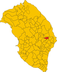
Carpignano Salentino
- Italian comune
Hiking in Carpignano Salentino
Carpignano Salentino is a charming village located in the Apulia region of Italy, known for its scenic beauty and rich cultural heritage. Hiking in this area offers a wonderful opportunity to experience the picturesque landscapes, traditional stone architecture, and the stunning Mediterranean coastline....
- Country:
- Postal Code: 73020
- Local Dialing Code: 0836
- Licence Plate Code: LE
- Coordinates: 40° 11' 49" N, 18° 20' 18" E
- GPS tracks (wikiloc): [Link]
- AboveSeaLevel: 76 м m
- Area: 48.99 sq km
- Population: 3753
- Web site: [Link]


Giurdignano
- Italian comune
Hiking in Giurdignano
Giurdignano, located in the province of Lecce in the Apulia region of Italy, is known for its beautiful landscapes, rich history, and unique geological formations. Here are some key aspects of hiking in this area:...
- Country:
- Postal Code: 73020
- Local Dialing Code: 0836
- Licence Plate Code: LE
- Coordinates: 40° 7' 0" N, 18° 26' 0" E
- GPS tracks (wikiloc): [Link]
- AboveSeaLevel: 78 м m
- Area: 14.04 sq km
- Population: 1943
- Web site: [Link]
Melendugno
- Italian comune
Hiking in Melendugno
Melendugno is a beautiful coastal town located in the Puglia region of Italy, known for its stunning landscapes, crystal-clear waters, and charming historical sites. While it's primarily famous for its beaches, such as those at Torre dell'Orso and San Foca, there are also opportunities for hiking and exploring nature in and around the area. Here are some highlights for hiking in Melendugno and its surroundings:...
- Country:
- Postal Code: 73026
- Local Dialing Code: 0832
- Licence Plate Code: LE
- Coordinates: 40° 16' 0" N, 18° 20' 0" E
- GPS tracks (wikiloc): [Link]
- AboveSeaLevel: 36 м m
- Area: 92.31 sq km
- Population: 9999
- Web site: [Link]

Palmariggi
- Italian comune
Hiking in Palmariggi
Palmariggi is a small village located in the province of Lecce in the Apulia region of Italy. While it may not be as well-known as some larger hiking destinations, it offers beautiful landscapes and opportunities for exploration, particularly for those interested in experiencing the natural beauty and local culture of southern Italy....
- Country:
- Postal Code: 73020
- Local Dialing Code: 0836
- Licence Plate Code: LE
- Coordinates: 40° 8' 0" N, 18° 23' 0" E
- GPS tracks (wikiloc): [Link]
- AboveSeaLevel: 99 м m
- Area: 8.97 sq km
- Population: 1495
- Web site: [Link]
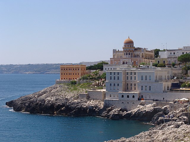

Santa Cesarea Terme
- Italian comune
Hiking in Santa Cesarea Terme
Santa Cesarea Terme, located on the Adriatic coast in the region of Puglia, Italy, is a wonderful destination for hiking enthusiasts. The area is known for its stunning coastal views, rich history, and diverse landscapes. Here’s an overview of what you can expect when hiking in this region:...
- Country:
- Postal Code: 73020
- Local Dialing Code: 0836
- Licence Plate Code: LE
- Coordinates: 40° 2' 10" N, 18° 27' 20" E
- GPS tracks (wikiloc): [Link]
- AboveSeaLevel: 56 м m
- Area: 26.82 sq km
- Population: 3017
- Web site: [Link]


Uggiano la Chiesa
- Italian comune
Hiking in Uggiano la Chiesa
Uggiano la Chiesa is a charming municipality located in the province of Lecce, in the region of Puglia, Italy. This area is rich in natural beauty, historical sites, and picturesque landscapes, making it an appealing destination for hikers....
- Country:
- Postal Code: 73020
- Local Dialing Code: 0836
- Licence Plate Code: LE
- Coordinates: 40° 6' 0" N, 18° 27' 0" E
- GPS tracks (wikiloc): [Link]
- AboveSeaLevel: 77 м m
- Area: 14.46 sq km
- Population: 4385
- Web site: [Link]