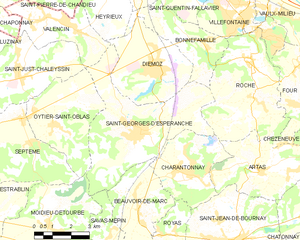
Oytier-Saint-Oblas (Oytier-Saint-Oblas)

- commune in Isère, France
 Hiking in Oytier-Saint-Oblas
Oytier-Saint-Oblas, situated in the Auvergne-Rhône-Alpes region of southeastern France, offers beautiful landscapes and a variety of hiking opportunities. Here are some key points to consider if you're planning to hike in this area:
Trails and Terrain
- Scenic Views: The region is characterized by rolling hills, forests, and agricultural fields, providing picturesque views throughout your hike.
- Trail Variety: There are various trails available for different skill levels. You can find easy, family-friendly paths as well as more challenging hikes that may involve elevation changes.
- Local Routes: Connect with local hiking maps or guides for specific trails. Some trails may lead to local historical sites or viewpoints.
Flora and Fauna
- Biodiversity: The Oytier-Saint-Oblas area is home to diverse plant and animal life. Keep an eye out for local wildlife, including birds and small mammals, as well as unique indigenous plant species.
- Seasons: The changing seasons can greatly affect the landscape, with wildflowers in spring and vibrant foliage in autumn.
Safety Considerations
- Weather Conditions: Always check the weather forecast before heading out, as conditions can change rapidly in mountainous terrain.
- Equipment: Wear appropriate hiking boots and consider bringing trekking poles for stability, especially on uneven terrain.
- Stay Hydrated: Bring enough water and snacks. There may not be many facilities along the trails.
Access and Amenities
- Getting There: Oytier-Saint-Oblas is accessible by car and may have public transportation options depending on your starting point.
- Local Services: Research accommodations or dining options if you plan to stay overnight. It can be a good idea to check for visitor centers where you can gather information or maps.
Cultural Aspects
- Local Heritage: Incorporate visits to historical sites or local communities during your hiking trip to enhance your experience of the region's culture.
Having an adventure in Oytier-Saint-Oblas can be a rewarding experience, blending nature with physical activity. Always remember to practice Leave No Trace principles to maintain the beauty of the area for others to enjoy. Happy hiking!
- Country:

- Postal Code: 38780
- Coordinates: 45° 33' 40" N, 5° 1' 15" E


- GPS tracks (wikiloc): [Link]
- Area: 14.3 sq km
- Population: 1621
- Web site: http://www.oytier.fr
- Wikipedia en: wiki(en)
- Wikipedia: wiki(fr)
- Wikidata storage: Wikidata: Q1068988
- Wikipedia Commons Category: [Link]
- Freebase ID: [/m/03nvgqr]
- GeoNames ID: Alt: [6433274]
- SIREN number: [213802887]
- BnF ID: [15258100f]
- Trismegistos Geo ID: [21680]
- INSEE municipality code: 38288
Shares border with regions:

Saint-Georges-d'Espéranche
- commune in Isère, France
Hiking in Saint-Georges-d'Espéranche
Saint-Georges-d'Espéranche is a charming commune located in the Isère department of the Auvergne-Rhône-Alpes region in southeastern France. While it may not be as widely known as some other hiking destinations in the region, it offers a range of outdoor activities and scenic landscapes that are perfect for hiking enthusiasts....
- Country:
- Postal Code: 38790
- Coordinates: 45° 33' 21" N, 5° 4' 39" E
- GPS tracks (wikiloc): [Link]
- Area: 24.65 sq km
- Population: 3321
- Web site: [Link]


Saint-Just-Chaleyssin
- commune in Isère, France
Hiking in Saint-Just-Chaleyssin
Saint-Just-Chaleyssin is a charming commune located in the Isère department of the Auvergne-Rhône-Alpes region in southeastern France. It offers various opportunities for hiking enthusiasts through scenic landscapes that showcase the beauty of both the natural environment and the local countryside....
- Country:
- Postal Code: 38540
- Coordinates: 45° 35' 6" N, 4° 59' 57" E
- GPS tracks (wikiloc): [Link]
- Area: 13.95 sq km
- Population: 2468
- Web site: [Link]


Moidieu-Détourbe
- commune in Isère, France
Hiking in Moidieu-Détourbe
Moidieu-Détourbe is a scenic municipality located in the Auvergne-Rhône-Alpes region of France, near the Rhône River. While it might not be as widely known as some other hiking destinations, it offers a beautiful landscape perfect for exploration....
- Country:
- Postal Code: 38440
- Coordinates: 45° 30' 43" N, 5° 0' 58" E
- GPS tracks (wikiloc): [Link]
- Area: 18.04 sq km
- Population: 1832
- Web site: [Link]

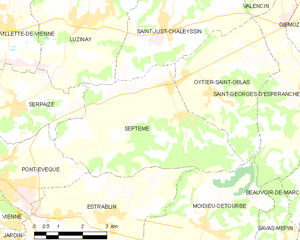
Septème
- commune in Isère, France
Hiking in Septème
Septème is a charming commune located in the Isère department of southeastern France, near the city of Grenoble. The region offers beautiful natural landscapes, which makes it an appealing destination for hiking enthusiasts....
- Country:
- Postal Code: 38780
- Coordinates: 45° 33' 8" N, 5° 0' 15" E
- GPS tracks (wikiloc): [Link]
- Area: 21.55 sq km
- Population: 2004