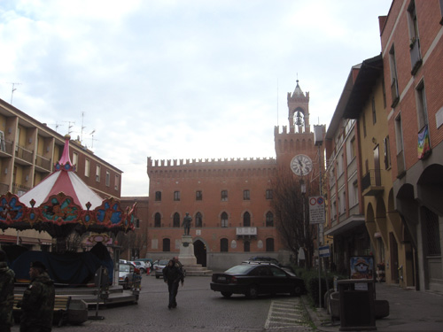
Ozzano dell'Emilia (Ozzano dell'Emilia)
.svg)
- Italian comune
 Hiking in Ozzano dell'Emilia
Ozzano dell'Emilia, located in the Emilia-Romagna region of Italy near Bologna, offers picturesque landscapes and a variety of hiking opportunities. The area is characterized by rolling hills, lush greenery, and a mix of agricultural and natural environments.
Hiking Trails:
-
Sentiero degli Dei:
- This trail offers stunning views of the surrounding countryside. It's relatively easy and suitable for beginners.
-
Gessi Bolognesi Nature Park:
- Just a short drive from Ozzano, this park features several well-marked trails that wind through unique geological formations and offer exploration of the local flora and fauna.
-
Valli di Ozzano:
- This area includes a series of pathways along the valleys, ideal for those looking for scenic walks. The trails are typically easy to moderate.
Preparation:
- Footwear: Wear sturdy hiking shoes or boots to handle the varied terrain.
- Weather: Check the weather forecast, as conditions can change, especially in the hills.
- Water and Snacks: Bring plenty of water and some snacks for energy along the way.
- Map & Compass: While trails are often marked, carrying a map or using a GPS can help ensure you stay on track.
Points of Interest:
- Local Culture: Along the trails, you may encounter local farms and vineyards, offering a chance to sample regional delicacies.
- Historical Sites: Look for ancient churches and historic ruins scattered throughout the landscape, adding a cultural dimension to your hike.
Safety Tips:
- Travel in Groups: Whenever possible, hike with a partner or group, especially in less-trafficked areas.
- Inform Someone: Let someone know your hiking route and expected return time.
- Wildlife: Be aware of local wildlife and respect their habitats.
Ozzano dell'Emilia offers a blend of natural beauty and cultural richness that makes it a fantastic destination for hikers of all levels. Active exploration of this beautiful area can lead to unforgettable experiences and a deeper appreciation for the Italian countryside.
- Country:

- Postal Code: 40064
- Local Dialing Code: 051
- Licence Plate Code: BO
- Coordinates: 44° 27' 0" N, 11° 29' 0" E


- GPS tracks (wikiloc): [Link]
- AboveSeaLevel: 67 м m
- Area: 64.95 sq km
- Population: 13819
- Web site: http://www.comune.ozzano.bo.it/
- Wikipedia en: wiki(en)
- Wikipedia: wiki(it)
- Wikidata storage: Wikidata: Q29080
- Wikipedia Commons Category: [Link]
- Freebase ID: [/m/0905nx]
- GeoNames ID: Alt: [3171759]
- VIAF ID: Alt: [124416259]
- OSM relation ID: [43110]
- Quora topic ID: [Ozzano-Dellemilia]
- UN/LOCODE: [ITOZE]
- ISTAT ID: 037046
- Italian cadastre code: G205
Shares border with regions:

Budrio
- Italian comune
Hiking in Budrio
Budrio, located in the Emilia-Romagna region of Italy, is a charming town known for its rich history and beautiful landscapes. While Budrio itself is not a major hiking destination like the nearby Apennines, there are still several opportunities for walking and exploring the natural scenery in and around the area....
- Country:
- Postal Code: 40054
- Local Dialing Code: 051
- Licence Plate Code: BO
- Coordinates: 44° 32' 15" N, 11° 32' 4" E
- GPS tracks (wikiloc): [Link]
- AboveSeaLevel: 26 м m
- Area: 120.18 sq km
- Population: 18440
- Web site: [Link]


Castel San Pietro Terme
- Italian comune
Hiking in Castel San Pietro Terme
Castel San Pietro Terme, located in the Emilia-Romagna region of Italy, offers a variety of hiking opportunities amidst beautiful landscapes and a rich cultural backdrop. The area is characterized by rolling hills, vineyards, and historical sites, making it an attractive destination for both nature lovers and outdoor enthusiasts....
- Country:
- Postal Code: 40024
- Local Dialing Code: 051
- Licence Plate Code: BO
- Coordinates: 44° 23' 52" N, 11° 35' 22" E
- GPS tracks (wikiloc): [Link]
- AboveSeaLevel: 75 м m
- Area: 148.42 sq km
- Population: 20862
- Web site: [Link]
Castenaso
- Italian comune
Hiking in Castenaso
Castenaso, located in the Emilia-Romagna region of Italy, is a charming town surrounded by scenic landscapes, making it a great area for hiking enthusiasts. While the town itself may not have extensive hiking routes, it serves as a gateway to explore the nearby hills and natural parks....
- Country:
- Postal Code: 40050; 40055
- Local Dialing Code: 051
- Licence Plate Code: BO
- Coordinates: 44° 30' 35" N, 11° 28' 14" E
- GPS tracks (wikiloc): [Link]
- AboveSeaLevel: 42 м m
- Area: 35.73 sq km
- Population: 15363
- Web site: [Link]
Medicina
- Italian comune
Hiking in Medicina
Medicina, located in the Emilia-Romagna region of Italy, is not primarily known as a hiking destination, but it is surrounded by beautiful landscapes that can provide a variety of hiking opportunities. The region's rich history, charming countryside, and proximity to the Apennine Mountains make it an appealing area for outdoor enthusiasts....
- Country:
- Postal Code: 40059
- Local Dialing Code: 051
- Licence Plate Code: BO
- Coordinates: 44° 29' 0" N, 11° 38' 0" E
- GPS tracks (wikiloc): [Link]
- AboveSeaLevel: 25 м m
- Area: 159.11 sq km
- Population: 16768
- Web site: [Link]


Monterenzio
- Italian comune
Hiking in Monterenzio
Monterenzio is a charming municipality located in the Emilia-Romagna region of Italy, surrounded by beautiful hills and natural landscapes, making it a fantastic location for hiking enthusiasts. Here are some highlights and things to consider if you're planning to hike in Monterenzio:...
- Country:
- Postal Code: 40050
- Local Dialing Code: 051
- Licence Plate Code: BO
- Coordinates: 44° 20' 0" N, 11° 24' 0" E
- GPS tracks (wikiloc): [Link]
- AboveSeaLevel: 207 м m
- Area: 105.26 sq km
- Population: 6110
- Web site: [Link]


Pianoro
- Italian comune
Hiking in Pianoro
Pianoro, located in the Emilia-Romagna region of Italy, offers a variety of hiking opportunities, characterized by its beautiful landscapes, rolling hills, and charming countryside. The area is not far from the city of Bologna, making it easily accessible for both locals and visitors....
- Country:
- Postal Code: 40065; 40067; 40060
- Local Dialing Code: 051
- Licence Plate Code: BO
- Coordinates: 44° 23' 0" N, 11° 20' 0" E
- GPS tracks (wikiloc): [Link]
- AboveSeaLevel: 200 м m
- Area: 107.13 sq km
- Population: 17503
- Web site: [Link]


San Lazzaro di Savena
- Italian comune
Hiking in San Lazzaro di Savena
San Lazzaro di Savena is a charming town located near Bologna, Italy, and offers a variety of hiking opportunities in the surrounding areas. The region is characterized by its picturesque hills, lush forests, and scenic landscapes, making it an excellent destination for outdoor enthusiasts....
- Country:
- Postal Code: 40068
- Local Dialing Code: 051
- Licence Plate Code: BO
- Coordinates: 44° 28' 4" N, 11° 24' 50" E
- GPS tracks (wikiloc): [Link]
- AboveSeaLevel: 62 м m
- Area: 44.72 sq km
- Population: 32473
- Web site: [Link]