Pianoro (Pianoro)
.svg)
- Italian comune
 Hiking in Pianoro
Pianoro, located in the Emilia-Romagna region of Italy, offers a variety of hiking opportunities, characterized by its beautiful landscapes, rolling hills, and charming countryside. The area is not far from the city of Bologna, making it easily accessible for both locals and visitors.
Hiking Trails:
-
Sentiero dei Bianchi: This scenic trail provides a wonderful experience for hikers, leading through lush woodlands and offering panoramic views of the surrounding hills. The path is well-marked and varies in difficulty, making it suitable for different skill levels.
-
Monte della Calvana: For those looking for a bit of a challenge, hiking to Monte della Calvana can be rewarding. This hike gives you the chance to explore the natural beauty of the area while enjoying breathtaking views from the summit.
-
Gessi Bolognesi Regional Park: Nearby, this regional park offers several hiking routes. The trails wind through unique rock formations and typical Mediterranean vegetation. It’s an excellent spot for both hiking and birdwatching.
Tips for Hiking in Pianoro:
-
Best Time to Hike: Spring and fall are ideal seasons for hiking, with mild temperatures and beautiful scenery. Summer can be hot, while winter may bring snow in higher elevations.
-
Preparation: Wear sturdy hiking boots, dress in layers, and carry plenty of water and snacks. It’s also wise to carry a map or GPS device, as some trails may not be clearly marked.
-
Respect Nature: Stick to marked trails and be mindful of the local wildlife and plant life. Carry out any trash you bring in and leave the environment as you found it.
-
Local Resources: Check with local tourism offices for updated trail information, maps, and any guided tours that may be available.
Hiking in Pianoro allows you to appreciate the tranquility of nature while exploring the picturesque landscape, making it a great destination for outdoor enthusiasts.
- Country:

- Postal Code: 40065; 40067; 40060
- Local Dialing Code: 051
- Licence Plate Code: BO
- Coordinates: 44° 23' 0" N, 11° 20' 0" E


- GPS tracks (wikiloc): [Link]
- AboveSeaLevel: 200 м m
- Area: 107.13 sq km
- Population: 17503
- Web site: http://www.comune.pianoro.bo.it/
- Wikipedia en: wiki(en)
- Wikipedia: wiki(it)
- Wikidata storage: Wikidata: Q94979
- Wikipedia Commons Gallery: [Link]
- Wikipedia Commons Category: [Link]
- Freebase ID: [/m/06ymdh]
- GeoNames ID: Alt: [6542084]
- VIAF ID: Alt: [235658712]
- OSM relation ID: [43050]
- MusicBrainz area ID: [0527e35b-de71-4c53-bc0b-5f68b33aae39]
- UN/LOCODE: [ITPNR]
- ISTAT ID: 037047
- Italian cadastre code: G570
Shares border with regions:
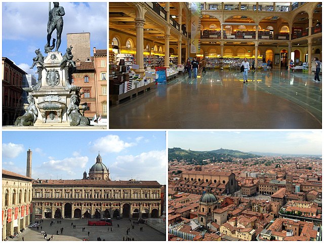
Bologna
- city in Emilia-Romagna, Italy
Hiking in Bologna
Bologna, known for its rich culture, gastronomy, and history, also offers some lovely opportunities for hiking and outdoor activities in its surrounding areas. Here's a guide to hiking in and around Bologna:...
- Country:
- Postal Code: 40121–40141
- Local Dialing Code: 051
- Licence Plate Code: BO
- Coordinates: 44° 29' 38" N, 11° 20' 34" E
- GPS tracks (wikiloc): [Link]
- AboveSeaLevel: 54 м m
- Area: 140.86 sq km
- Population: 388367
- Web site: [Link]
Ozzano dell'Emilia
- Italian comune
Hiking in Ozzano dell'Emilia
Ozzano dell'Emilia, located in the Emilia-Romagna region of Italy near Bologna, offers picturesque landscapes and a variety of hiking opportunities. The area is characterized by rolling hills, lush greenery, and a mix of agricultural and natural environments....
- Country:
- Postal Code: 40064
- Local Dialing Code: 051
- Licence Plate Code: BO
- Coordinates: 44° 27' 0" N, 11° 29' 0" E
- GPS tracks (wikiloc): [Link]
- AboveSeaLevel: 67 м m
- Area: 64.95 sq km
- Population: 13819
- Web site: [Link]


Loiano
- Italian comune
Hiking in Loiano
Loiano is a picturesque town located in the Emilia-Romagna region of Italy, nestled in the Apennine Mountains. It serves as an excellent base for hiking enthusiasts, offering a variety of trails that cater to different skill levels and preferences. Here are some key points to consider when hiking in Loiano:...
- Country:
- Postal Code: 40050
- Local Dialing Code: 051
- Licence Plate Code: BO
- Coordinates: 44° 16' 0" N, 11° 19' 0" E
- GPS tracks (wikiloc): [Link]
- AboveSeaLevel: 714 м m
- Area: 52.41 sq km
- Population: 4288
- Web site: [Link]


Monterenzio
- Italian comune
Hiking in Monterenzio
Monterenzio is a charming municipality located in the Emilia-Romagna region of Italy, surrounded by beautiful hills and natural landscapes, making it a fantastic location for hiking enthusiasts. Here are some highlights and things to consider if you're planning to hike in Monterenzio:...
- Country:
- Postal Code: 40050
- Local Dialing Code: 051
- Licence Plate Code: BO
- Coordinates: 44° 20' 0" N, 11° 24' 0" E
- GPS tracks (wikiloc): [Link]
- AboveSeaLevel: 207 м m
- Area: 105.26 sq km
- Population: 6110
- Web site: [Link]


Monzuno
- Italian comune
Hiking in Monzuno
Monzuno is located in the Emilia-Romagna region of Italy, nestled within the beautiful hills of the Apennine Mountains. It’s a wonderful destination for hikers and nature enthusiasts, offering a variety of trails that cater to different skill levels. Here are some highlights to consider when hiking in Monzuno:...
- Country:
- Postal Code: 40036
- Local Dialing Code: 051
- Licence Plate Code: BO
- Coordinates: 44° 17' 0" N, 11° 16' 0" E
- GPS tracks (wikiloc): [Link]
- AboveSeaLevel: 621 м m
- Area: 65.01 sq km
- Population: 6375
- Web site: [Link]


San Lazzaro di Savena
- Italian comune
Hiking in San Lazzaro di Savena
San Lazzaro di Savena is a charming town located near Bologna, Italy, and offers a variety of hiking opportunities in the surrounding areas. The region is characterized by its picturesque hills, lush forests, and scenic landscapes, making it an excellent destination for outdoor enthusiasts....
- Country:
- Postal Code: 40068
- Local Dialing Code: 051
- Licence Plate Code: BO
- Coordinates: 44° 28' 4" N, 11° 24' 50" E
- GPS tracks (wikiloc): [Link]
- AboveSeaLevel: 62 м m
- Area: 44.72 sq km
- Population: 32473
- Web site: [Link]

Sasso Marconi
- Italian comune
Hiking in Sasso Marconi
Sasso Marconi, located in the Emilia-Romagna region of Italy, is a great area for hiking enthusiasts. Nestled in the Apennine Mountains, it offers a range of trails suited for different skill levels, with beautiful landscapes that include hills, forests, and panoramic views of the surrounding countryside....
- Country:
- Postal Code: 40037
- Local Dialing Code: 051
- Licence Plate Code: BO
- Coordinates: 44° 24' 0" N, 11° 15' 0" E
- GPS tracks (wikiloc): [Link]
- AboveSeaLevel: 128 м m
- Area: 96.45 sq km
- Population: 14903
- Web site: [Link]