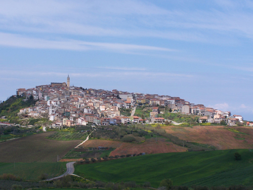
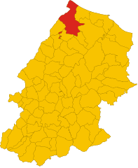
Palata (Palata)
.svg)
- Italian comune
 Hiking in Palata
Palata, a small town in the Molise region of Italy, offers a scenic backdrop for hiking enthusiasts. Nestled in the Apennine Mountains, the area is characterized by rolling hills, lush forests, and captivating views. Here are some key points to consider if you're planning to hike in and around Palata:
Hiking Trails
- Local Trails: There are several hiking trails around Palata that highlight the natural beauty of the region. These trails vary in difficulty, catering to both beginners and experienced hikers.
- Nature Reserves: Explore nearby nature reserves, such as the Parco Nazionale d'Abruzzo, which is not too far from Palata. It boasts diverse flora and fauna, offering ample opportunities for wildlife viewing.
- Historical Trails: Some trails also lead to historical sites, providing a cultural experience along with hiking. Look for paths that take you to ancient churches or remnants of old villages.
Highlights
- Views and Photography: The panoramic views from higher ground offer stunning landscapes, perfect for photography. Early morning or late afternoon light can enhance the scenery.
- Local Flora and Fauna: The region is rich in biodiversity, and hikers may see various plant species and possibly wildlife such as deer, foxes, and numerous bird species.
Practical Tips
- Season: The best times for hiking in Palata are spring and early fall when the weather is mild, and the landscapes are vibrant.
- Gear: Ensure you wear appropriate hiking boots and pack sufficient water, snacks, and a map or GPS device, as some trails may not be well-marked.
- Guided Tours: If you're unfamiliar with the area or prefer a guided experience, consider hiring a local guide who can provide insight into the region's ecology and history.
Local Culture
After a day of hiking, you might find it rewarding to explore the local culture, enjoy traditional Molise cuisine, and interact with the friendly locals. Palata has a charming atmosphere that reflects the rich heritage of the region.
Remember to respect nature, follow trail etiquette, and carry out what you bring in to help preserve the beautiful landscapes for future visitors! Enjoy your hiking adventure in Palata!
- Country:

- Postal Code: 86037
- Local Dialing Code: 0875
- Licence Plate Code: CB
- Coordinates: 41° 53' 16" N, 14° 47' 16" E


- GPS tracks (wikiloc): [Link]
- AboveSeaLevel: 520 м m
- Area: 43.82 sq km
- Population: 1676
- Web site: http://www.comune.palata.cb.it/
- Wikipedia en: wiki(en)
- Wikipedia: wiki(it)
- Wikidata storage: Wikidata: Q277847
- Wikipedia Commons Category: [Link]
- Freebase ID: [/m/0gnphh]
- GeoNames ID: Alt: [6539833]
- VIAF ID: Alt: [122772214]
- OSM relation ID: [41589]
- ISTAT ID: 070050
- Italian cadastre code: G257
Shares border with regions:
Acquaviva Collecroce
- Italian comune
Hiking in Acquaviva Collecroce
Acquaviva Collecroce is a small village located in the Molise region of Italy, known for its stunning landscapes and diverse hiking opportunities. Nestled in the Apennine Mountains, the area offers several trails that showcase the natural beauty and cultural heritage of the region. Here are some highlights of hiking in and around Acquaviva Collecroce:...
- Country:
- Postal Code: 86030
- Local Dialing Code: 0875
- Licence Plate Code: CB
- Coordinates: 41° 52' 0" N, 14° 45' 0" E
- GPS tracks (wikiloc): [Link]
- AboveSeaLevel: 425 м m
- Area: 28.6 sq km
- Population: 644
- Web site: [Link]


Guardialfiera
- Italian comune
Hiking in Guardialfiera
Guardialfiera is a beautiful destination located in the Molise region of Italy, known for its stunning landscapes and outdoor recreational opportunities, especially hiking. Here are some key points about hiking in Guardialfiera:...
- Country:
- Postal Code: 86030
- Local Dialing Code: 0874
- Licence Plate Code: CB
- Coordinates: 41° 48' 13" N, 14° 47' 36" E
- GPS tracks (wikiloc): [Link]
- AboveSeaLevel: 274 м m
- Area: 43.53 sq km
- Population: 1045
- Web site: [Link]


Guglionesi
- Italian comune
Hiking in Guglionesi
Guglionesi is a charming village located in the Molise region of Italy, surrounded by beautiful countryside and rolling hills, making it a great destination for hiking enthusiasts. Here's what you can expect when hiking in and around Guglionesi:...
- Country:
- Postal Code: 86034
- Local Dialing Code: 0875
- Licence Plate Code: CB
- Coordinates: 41° 55' 0" N, 14° 55' 0" E
- GPS tracks (wikiloc): [Link]
- AboveSeaLevel: 369 м m
- Area: 100.95 sq km
- Population: 5246
- Web site: [Link]


Larino
- Italian comune
Hiking in Larino
Larino, located in the Molise region of Italy, is a small town rich in history and natural beauty, making it a charming destination for hiking enthusiasts. The surrounding area offers a variety of hiking trails that cater to different skill levels. Here are some highlights to consider when hiking in Larino:...
- Country:
- Postal Code: 86035
- Local Dialing Code: 0874
- Licence Plate Code: CB
- Coordinates: 41° 48' 0" N, 14° 55' 0" E
- GPS tracks (wikiloc): [Link]
- AboveSeaLevel: 341 м m
- Area: 88.77 sq km
- Population: 6680
- Web site: [Link]
Montecilfone
- Italian comune
Hiking in Montecilfone
Montecilfone is a small village located in the Molise region of Italy, known for its stunning landscapes and natural beauty. Hiking in this area can be a delightful experience due to the picturesque views, varied terrain, and the charm of the local culture....
- Country:
- Postal Code: 86032
- Local Dialing Code: 0875
- Licence Plate Code: CB
- Coordinates: 41° 54' 0" N, 14° 50' 0" E
- GPS tracks (wikiloc): [Link]
- AboveSeaLevel: 405 м m
- Area: 22.92 sq km
- Population: 1355
- Web site: [Link]
Montenero di Bisaccia
- Italian comune
Hiking in Montenero di Bisaccia
Montenero di Bisaccia is a charming town located in the Molise region of Italy, known for its beautiful landscapes and outdoor activities, including hiking. The area offers a unique blend of rolling hills, coastal views, and rustic countryside, making it an attractive spot for hikers seeking both tranquility and scenic beauty....
- Country:
- Postal Code: 86036
- Local Dialing Code: 0875
- Licence Plate Code: CB
- Coordinates: 41° 57' 0" N, 14° 47' 0" E
- GPS tracks (wikiloc): [Link]
- AboveSeaLevel: 273 м m
- Area: 93.32 sq km
- Population: 6612
- Web site: [Link]
Tavenna
- Italian comune
Hiking in Tavenna
Tavenna is a charming town located in the Molise region of Italy, surrounded by stunning natural landscapes that are perfect for hiking. The area offers a range of trails, suitable for various skill levels, allowing hikers to explore the beautiful countryside, hills, and possibly even the nearby mountains....
- Country:
- Postal Code: 86030
- Local Dialing Code: 0875
- Licence Plate Code: CB
- Coordinates: 41° 55' 0" N, 14° 46' 0" E
- GPS tracks (wikiloc): [Link]
- AboveSeaLevel: 550 м m
- Area: 21.97 sq km
- Population: 875
- Web site: [Link]