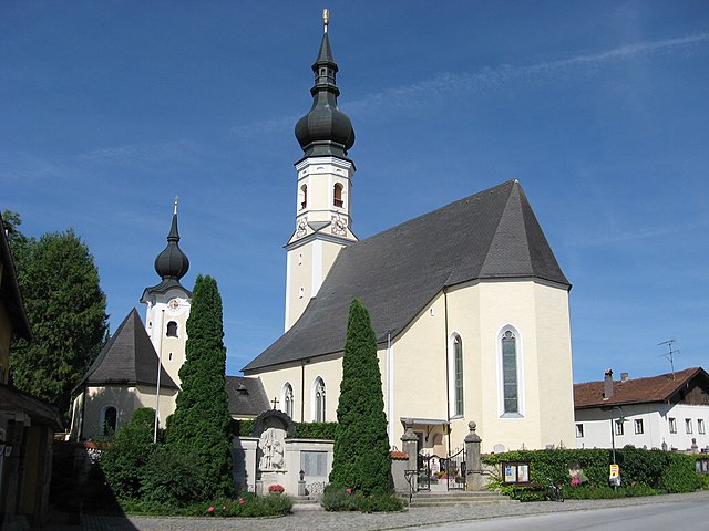
Palting (Palting)
- municipality in Austria
It seems there may be a misunderstanding, as "Palting" is not a widely recognized hiking destination. However, if you meant a specific region, trail, or country with a similar name, please clarify, or if you're looking for general hiking information, I’d be happy to help!
If you’re referring to a hiking area in particular, I can provide information on popular trails, difficulty levels, necessary gear, best times to hike, and safety tips. Just let me know what you need!
- Country:

- Postal Code: 5163
- Local Dialing Code: 06217
- Licence Plate Code: BR
- Coordinates: 48° 1' 0" N, 13° 7' 40" E


- GPS tracks (wikiloc): [Link]
- AboveSeaLevel: 514 м m
- Area: 11.51 sq km
- Population: 938
- Web site: http://www.palting.at/
- Wikipedia en: wiki(en)
- Wikipedia: wiki(de)
- Wikidata storage: Wikidata: Q669124
- Wikipedia Commons Category: [Link]
- Freebase ID: [/m/03gv2jl]
- GeoNames ID: Alt: [7871980]
- VIAF ID: Alt: [307295709]
- Austrian municipality key: [40429]
Includes regions:
Imsee
- human settlement in Austria
Imsee is a lovely area within the Gemeinde Palting in Austria that offers beautiful hiking opportunities. Situated near the borders of Salzburg and Upper Austria, it's known for its stunning landscapes, natural beauty, and relatively peaceful trails....
- Country:

- Coordinates: 48° 1' 13" N, 13° 7' 56" E


- GPS tracks (wikiloc): [Link]
Mundenham
- human settlement in Austria
Mundenham is not widely recognized as a popular hiking destination, which might be why specific details about it are less commonly available. However, if you’re referring to a more localized area or a lesser-known trail named Mundenham, it’s possible there are scenic routes and natural landscapes worth exploring....
- Country:

- Coordinates: 48° 0' 27" N, 13° 7' 44" E


- GPS tracks (wikiloc): [Link]
Shares border with regions:

Berndorf bei Salzburg
- municipality in Austria
 Hiking in Berndorf bei Salzburg
Berndorf bei Salzburg, located near the city of Salzburg in Austria, is a picturesque area that offers a variety of hiking opportunities for different skill levels. The region is characterized by its stunning landscapes, rolling hills, and beautiful views of the surrounding mountains, making it a great destination for outdoor enthusiasts....
- Country:

- Postal Code: 5165
- Local Dialing Code: 06217
- Licence Plate Code: SL
- Coordinates: 47° 58' 0" N, 13° 4' 0" E


- GPS tracks (wikiloc): [Link]
- AboveSeaLevel: 548 м m
- Area: 14.48 sq km
- Population: 1689
- Web site: [Link]
Perwang am Grabensee
- municipality in Austria
 Hiking in Perwang am Grabensee
Perwang am Grabensee is a picturesque village in Austria, located near the shores of Lake Grabensee, which offers a serene environment perfect for hiking enthusiasts. The area boasts stunning natural landscapes, making it a great destination for hikers of all levels....
- Country:

- Postal Code: 5166
- Local Dialing Code: 06217
- Licence Plate Code: BR
- Coordinates: 48° 0' 20" N, 13° 5' 0" E


- GPS tracks (wikiloc): [Link]
- AboveSeaLevel: 531 м m
- Area: 6.83 sq km
- Population: 997
- Web site: [Link]
Kirchberg bei Mattighofen
- municipality in Austria
 Hiking in Kirchberg bei Mattighofen
Kirchberg bei Mattighofen is a charming village located in the Austrian state of Upper Austria, surrounded by beautiful landscapes that are ideal for hiking enthusiasts. The region offers a variety of trails, catering to different skill levels and allowing hikers to explore the picturesque countryside, forests, and hills. Here are some highlights to consider for your hiking experience in this area:...
- Country:

- Postal Code: 5232
- Local Dialing Code: 07747
- Licence Plate Code: BR
- Coordinates: 48° 2' 22" N, 13° 6' 2" E


- GPS tracks (wikiloc): [Link]
- AboveSeaLevel: 560 м m
- Area: 15.74 sq km
- Population: 1175
- Web site: [Link]

Lochen am See
- municipality in Austria
Lochen am See is a beautiful village located near Lake Pichlinger, in the Upper Austria region, and offers a range of hiking opportunities suitable for various skill levels. Here are some highlights and tips for hiking in this area:...
- Country:

- Postal Code: 5221
- Local Dialing Code: 07745
- Licence Plate Code: BR
- Coordinates: 48° 2' 0" N, 13° 11' 0" E


- GPS tracks (wikiloc): [Link]
- AboveSeaLevel: 516 м m
- Area: 33.3 sq km
- Population: 2754
- Web site: [Link]

Mattsee
- municipality in Austria
Mattsee, located in the stunning Salzburg region of Austria, is a fantastic destination for hiking enthusiasts. The area is characterized by picturesque landscapes, rolling hills, and scenic lakes, making it perfect for both casual strolls and more challenging hikes....
- Country:

- Postal Code: 5163
- Local Dialing Code: 06217
- Licence Plate Code: SL
- Coordinates: 47° 58' 0" N, 13° 5' 0" E


- GPS tracks (wikiloc): [Link]
- AboveSeaLevel: 505 м m
- Area: 24.59 sq km
- Population: 3263
- Web site: [Link]