Parmilieu (Parmilieu)
- commune in Isère, France
Parmilieu is a charming commune located in the Isère department of the Auvergne-Rhône-Alpes region in southeastern France. The area is characterized by its beautiful natural scenery, which offers excellent opportunities for hiking and outdoor activities. Here are some highlights and tips for hiking in and around Parmilieu:
Trails and Terrain
- Local Trails: Parmilieu and its surrounding region have several scenic hiking trails that range from easy walks to more challenging hikes. You can explore forests, meadows, and small hills that offer beautiful vistas of the surrounding landscape.
- Breathtaking Views: Many trails provide stunning views of the Chartreuse Mountains and the overall landscape of the Rhône-Alpes region. Look for viewpoints along the way to enjoy the natural beauty.
Accessibility
- Trail Access: Most trails in Parmilieu are accessible and can be enjoyed by hikers of varying skill levels. Whether you’re a beginner or an experienced hiker, you'll find a suitable route.
- Signage: Trails are generally well-marked with signage, making navigation easier for hikers.
Local Flora and Fauna
- The area is rich in biodiversity, offering chances to spot various wildlife and plant species. Look out for local birds, deer, and native plants as you explore the trails.
Recommended Preparations
- Weather Conditions: Before heading out, always check the weather conditions, as they can change quickly in mountainous areas. Dress in layers and be prepared for both sun and rain.
- Footwear: Sturdy hiking boots are recommended, as some trails may be rocky or uneven.
- Hydration and Nutrition: Carry enough water and snacks to keep your energy levels up during your hike.
Local Attractions
- After your hike, consider visiting local attractions such as historical sites or nearby villages to experience the culture and gastronomy of the region.
Safety Tips
- Always inform someone about your hiking plans and expected return time.
- Hike with a buddy if possible, especially on longer trails or if you are unfamiliar with the area.
Enjoy your hiking adventure in and around Parmilieu! The combination of stunning landscapes and rich natural heritage makes it a memorable experience.
- Country:

- Postal Code: 38390
- Coordinates: 45° 50' 25" N, 5° 21' 18" E


- GPS tracks (wikiloc): [Link]
- Area: 12.83 sq km
- Population: 691
- Web site: http://parmilieu.fr
- Wikipedia en: wiki(en)
- Wikipedia: wiki(fr)
- Wikidata storage: Wikidata: Q1068879
- Wikipedia Commons Category: [Link]
- Freebase ID: [/m/03nvgj6]
- GeoNames ID: Alt: [6433280]
- SIREN number: [213802952]
- BnF ID: [15258107v]
- INSEE municipality code: 38295
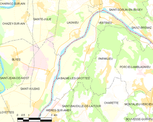
Shares border with regions:


Charette
- commune in Isère, France
Charette is a small commune located in the Isère department of the Auvergne-Rhône-Alpes region in southeastern France. This area is known for its scenic landscapes, diverse terrain, and opportunities for outdoor activities, including hiking....
- Country:

- Postal Code: 38390
- Coordinates: 45° 48' 37" N, 5° 22' 14" E


- GPS tracks (wikiloc): [Link]
- Area: 11.26 sq km
- Population: 464


La Balme-les-Grottes
- commune in Isère, France
 Hiking in La Balme-les-Grottes
La Balme-les-Grottes is a charming village in the Auvergne-Rhône-Alpes region of France, known for its stunning natural surroundings and the remarkable geological formations that attract hikers and outdoor enthusiasts. Here are some highlights regarding hiking in this area:...
- Country:

- Postal Code: 38390
- Coordinates: 45° 51' 9" N, 5° 20' 12" E


- GPS tracks (wikiloc): [Link]
- Area: 14.61 sq km
- Population: 1011
- Web site: [Link]


Vertrieu
- commune in Isère, France
Vertrieu is a great destination for hiking enthusiasts. Located in the Auvergne-Rhône-Alpes region of France, it offers beautiful natural landscapes and a variety of trails suitable for different skill levels. Here are some highlights for hiking in the area:...
- Country:

- Postal Code: 38390
- Coordinates: 45° 52' 24" N, 5° 22' 1" E


- GPS tracks (wikiloc): [Link]
- Area: 4.59 sq km
- Population: 666
- Web site: [Link]


Saint-Baudille-de-la-Tour
- commune in Isère, France
 Hiking in Saint-Baudille-de-la-Tour
Saint-Baudille-de-la-Tour is a charming commune located in the Isère department in the Auvergne-Rhône-Alpes region of southeastern France. It serves as an excellent starting point for outdoor activities, including hiking, thanks to its scenic landscapes and proximity to the Alps....
- Country:

- Postal Code: 38118
- Coordinates: 45° 47' 23" N, 5° 20' 18" E


- GPS tracks (wikiloc): [Link]
- Area: 21.76 sq km
- Population: 797
- Web site: [Link]


Porcieu-Amblagnieu
- commune in Isère, France
Porcieu-Amblagnieu is a charming commune located in the Isère department of the Auvergne-Rhône-Alpes region in France. This area is characterized by its beautiful natural landscapes, rolling hills, and proximity to the Alps, making it a fantastic destination for hiking enthusiasts....
- Country:

- Postal Code: 38390
- Coordinates: 45° 50' 3" N, 5° 24' 4" E


- GPS tracks (wikiloc): [Link]
- Area: 15.8 sq km
- Population: 1759
- Web site: [Link]
