Porcieu-Amblagnieu (Porcieu-Amblagnieu)

- commune in Isère, France
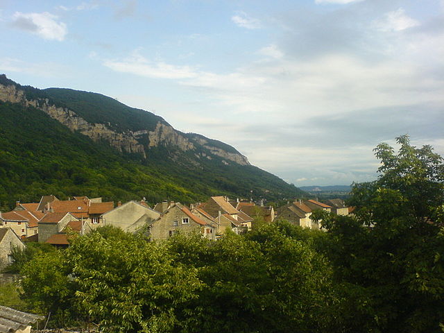
 Hiking in Porcieu-Amblagnieu
Porcieu-Amblagnieu is a charming commune located in the Isère department of the Auvergne-Rhône-Alpes region in France. This area is characterized by its beautiful natural landscapes, rolling hills, and proximity to the Alps, making it a fantastic destination for hiking enthusiasts.
Hiking Opportunities
-
Scenic Trails: There are numerous trails around Porcieu-Amblagnieu that offer stunning views of the surrounding countryside and mountains. The trails vary in difficulty, catering to both beginners and more experienced hikers.
-
Nature Observations: The region is home to diverse flora and fauna. During your hikes, you may encounter a variety of wildlife and enjoy the tranquility of nature.
-
Cultural Experiences: Hiking in this area not only offers natural beauty but also the opportunity to explore local history and culture. You might come across historical sites and charming villages along your routes.
Suggested Trails
While specific trail maps may not be readily available, local tourism websites or visitor information centers can provide detailed maps and recommendations. Look for trails that lead to viewpoints or along rivers for the best experiences.
Practical Tips
- Best Time to Hike: Spring and early fall are ideal for hiking in this region, as the weather is typically mild and the scenery is vibrant.
- Gear: Make sure to wear appropriate hiking shoes and bring essentials like water, snacks, and a map or a GPS device.
- Local Regulations: Always check for any local regulations regarding trail access or wildlife protection to ensure a safe and respectful hiking experience.
Nearby Attractions
While hiking in Porcieu-Amblagnieu, consider visiting nearby attractions like lakes or historical sites that can complement your outdoor adventure.
Overall, Porcieu-Amblagnieu offers a wonderful opportunity for hiking, surrounded by natural beauty and cultural richness. Enjoy your outdoor adventure!
- Country:

- Postal Code: 38390
- Coordinates: 45° 50' 3" N, 5° 24' 4" E


- GPS tracks (wikiloc): [Link]
- Area: 15.8 sq km
- Population: 1759
- Web site: http://www.porcieu-amblagnieu.fr
- Wikipedia en: wiki(en)
- Wikipedia: wiki(fr)
- Wikidata storage: Wikidata: Q602635
- Wikipedia Commons Category: [Link]
- Freebase ID: [/m/03nvhtt]
- GeoNames ID: Alt: [6433294]
- SIREN number: [213803208]
- BnF ID: [152581322]
- INSEE municipality code: 38320
Shares border with regions:


Charette
- commune in Isère, France
Hiking in Charette
Charette is a small commune located in the Isère department of the Auvergne-Rhône-Alpes region in southeastern France. This area is known for its scenic landscapes, diverse terrain, and opportunities for outdoor activities, including hiking....
- Country:
- Postal Code: 38390
- Coordinates: 45° 48' 37" N, 5° 22' 14" E
- GPS tracks (wikiloc): [Link]
- Area: 11.26 sq km
- Population: 464


Vertrieu
- commune in Isère, France
Hiking in Vertrieu
Vertrieu is a great destination for hiking enthusiasts. Located in the Auvergne-Rhône-Alpes region of France, it offers beautiful natural landscapes and a variety of trails suitable for different skill levels. Here are some highlights for hiking in the area:...
- Country:
- Postal Code: 38390
- Coordinates: 45° 52' 24" N, 5° 22' 1" E
- GPS tracks (wikiloc): [Link]
- Area: 4.59 sq km
- Population: 666
- Web site: [Link]


Parmilieu
- commune in Isère, France
Hiking in Parmilieu
Parmilieu is a charming commune located in the Isère department of the Auvergne-Rhône-Alpes region in southeastern France. The area is characterized by its beautiful natural scenery, which offers excellent opportunities for hiking and outdoor activities. Here are some highlights and tips for hiking in and around Parmilieu:...
- Country:
- Postal Code: 38390
- Coordinates: 45° 50' 25" N, 5° 21' 18" E
- GPS tracks (wikiloc): [Link]
- Area: 12.83 sq km
- Population: 691
- Web site: [Link]


Montalieu-Vercieu
- commune in Isère, France
Hiking in Montalieu-Vercieu
Montalieu-Vercieu is a charming commune located in the Ain department of the Auvergne-Rhône-Alpes region in southeastern France. The surrounding area offers various hiking opportunities, making it an attractive destination for outdoor enthusiasts....
- Country:
- Postal Code: 38390
- Coordinates: 45° 48' 51" N, 5° 24' 13" E
- GPS tracks (wikiloc): [Link]
- Area: 8.66 sq km
- Population: 3387
- Web site: [Link]

Sault-Brénaz
- commune in Ain, France
Hiking in Sault-Brénaz
Sault-Brénaz is a charming commune located in the Isère department in the Auvergne-Rhône-Alpes region of southeastern France. While it may not be as widely known as some other hiking destinations, it offers picturesque landscapes and trails suitable for various skill levels. Here are some points to consider when hiking in and around Sault-Brénaz:...
- Country:
- Postal Code: 01150
- Coordinates: 45° 51' 19" N, 5° 24' 36" E
- GPS tracks (wikiloc): [Link]
- Area: 5.61 sq km
- Population: 985
- Web site: [Link]
Villebois
- commune in Ain, France
Hiking in Villebois
Villebois is a charming commune located in the Drome region of southeastern France. It's known for its picturesque landscapes, rolling hills, and historical sites, making it an inviting destination for hikers....
- Country:
- Postal Code: 01150
- Coordinates: 45° 50' 52" N, 5° 26' 6" E
- GPS tracks (wikiloc): [Link]
- Area: 14.46 sq km
- Population: 1167
- Web site: [Link]