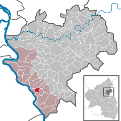
Patersberg (Patersberg)
- municipality of Germany
Patersberg, a picturesque village located in the scenic region of Germany, offers a serene environment ideal for hiking enthusiasts. Nestled in the Rheinland-Palatinate area, it serves as a gateway to various beautiful trails and natural attractions. Here are some highlights about hiking in and around Patersberg:
-
Scenic Trails: The region features a range of hiking trails that cater to different skill levels. You can find flat, easy paths perfect for family strolls, as well as more challenging routes for seasoned hikers.
-
Natural Beauty: The trails around Patersberg take you through lush forests, rolling hills, and alongside rivers, showcasing the beautiful winter and green landscapes characteristic of the area.
-
Historical Sites: While hiking, you might come across old ruins, charming villages, and historical landmarks, providing a unique cultural experience alongside your outdoor adventure.
-
Wildlife Spotting: The area around Patersberg is rich in biodiversity. Keep an eye out for local wildlife, including various bird species, deer, and other forest animals while you hike.
-
Local Amenities: After a day on the trails, you can enjoy local amenities such as cozy guesthouses, cafes, and restaurants that offer regional cuisine, giving you the chance to refuel after your hike.
-
Accessibility: Patersberg is well connected by road and public transport, making it easier to access the starting points of several hiking trails, as well as other nearby attractions.
-
Seasonal Considerations: Be sure to check the weather and trail conditions before your hike, especially in winter when some paths might be more challenging due to snow or ice.
When planning your hike in Patersberg, it's essential to wear appropriate footwear, carry enough water, and pack some snacks to keep your energy up while enjoying the natural beauty of the region. Always remember to follow local guidelines and leave no trace to help preserve the environment!
- Country:

- Postal Code: 56348
- Local Dialing Code: 06771
- Licence Plate Code: EMS
- Coordinates: 50° 9' 28" N, 7° 44' 10" E


- GPS tracks (wikiloc): [Link]
- AboveSeaLevel: 242 м m
- Area: 2.65 sq km
- Population: 380
- Web site: http://www.vgloreley.de
- Wikipedia en: wiki(en)
- Wikipedia: wiki(de)
- Wikidata storage: Wikidata: Q630989
- Wikipedia Commons Category: [Link]
- Freebase ID: [/m/02z3hvb]
- GeoNames ID: Alt: [2855274]
- VIAF ID: Alt: [238799714]
- OSM relation ID: [539910]
- GND ID: Alt: [4836366-2]
- Historical Gazetteer (GOV) ID: [PATERG_W5421]
- German municipality key: 07141109

